Latrobe Valley facts for kids
Quick facts for kids Latrobe ValleyVictoria |
|||||||||||||||
|---|---|---|---|---|---|---|---|---|---|---|---|---|---|---|---|
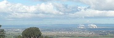
A view of part of the Latrobe Valley, from Tyers lookout, 2013.
|
|||||||||||||||
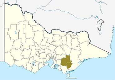
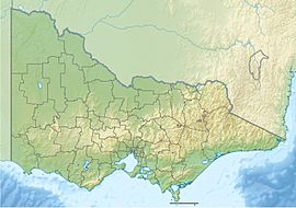
Approximate Latrobe Valley area, comprising the Baw Baw Shire and City of Latrobe local government areas.
|
|||||||||||||||
| Population | 125,000 | ||||||||||||||
| LGA(s) |
|
||||||||||||||
| Region | Gippsland | ||||||||||||||
| State electorate(s) |
|
||||||||||||||
| Federal Division(s) | Gippsland | ||||||||||||||
|
|||||||||||||||
|
|||||||||||||||
| Regions of Gippsland |
|---|
| East West South Central Latrobe Valley |
The Latrobe Valley is a special area in Victoria, Australia. It's part of the Gippsland region. This area is inland, meaning it's not on the coast.
The traditional owners of this land are the Brayakaulung people. They are part of the Gunai nation.
The Latrobe Valley is east of Melbourne. It sits between two mountain ranges. To the south are the Strzelecki Ranges. To the north are the Baw Baw Ranges. These northern ranges are part of the Great Dividing Range.
The highest mountain to the north is Mount St Phillack. It is about 1,567 m (5,141 ft) tall. The highest peak to the south is Mt Tassie. It is about 740 m (2,430 ft) tall.
The Latrobe Valley has three main towns. From west to east, they are Moe, Morwell, and Traralgon. Smaller towns include Churchill, Yinnar, Glengarry, and Tyers. Around 125,000 people live in the Latrobe Valley.
The valley gets its name from the Latrobe River. This river flows through the valley towards the east. In 1841, an early European settler named William Adams Brodribb named the river. He named it after Charles La Trobe, who was the Lieutenant Governor of the Port Phillip District.
Contents
What is the Latrobe Valley like?
The Latrobe Valley is an inland area. It's located between the Strzelecki Ranges and Baw Baw Ranges. The main towns are Moe, Morwell, and Traralgon. These towns are found between the Strzelecki Ranges in the south and the Victorian Alps in the north.
What is the climate like in Latrobe Valley?
The Latrobe Valley has a temperate climate. This means it has mild temperatures. It also gets a lot of rain. Sometimes there are frosts, and snow falls on the nearby hills.
February is the warmest month. Temperatures usually range from 12.5 to 26.4 °C (54.5 to 79.5 °F). July is the coldest month. Temperatures typically range from 3.6 to 13.5 °C (38.5 to 56.3 °F). Most rain falls in late winter and spring. The area gets about 800 millimetres (31 in) of rain each year.
| Climate data for Morwell (Latrobe Valley Airport, 1984–2020); 56 m AMSL; 38.21° S, 146.47° E | |||||||||||||
|---|---|---|---|---|---|---|---|---|---|---|---|---|---|
| Month | Jan | Feb | Mar | Apr | May | Jun | Jul | Aug | Sep | Oct | Nov | Dec | Year |
| Record high °C (°F) | 45.1 (113.2) |
46.3 (115.3) |
40.4 (104.7) |
35.0 (95.0) |
26.7 (80.1) |
23.5 (74.3) |
21.8 (71.2) |
26.8 (80.2) |
31.0 (87.8) |
35.1 (95.2) |
38.6 (101.5) |
42.2 (108.0) |
46.3 (115.3) |
| Mean daily maximum °C (°F) | 26.2 (79.2) |
26.5 (79.7) |
24.4 (75.9) |
20.5 (68.9) |
16.9 (62.4) |
14.2 (57.6) |
13.6 (56.5) |
14.9 (58.8) |
16.9 (62.4) |
19.3 (66.7) |
21.6 (70.9) |
24.0 (75.2) |
19.9 (67.8) |
| Mean daily minimum °C (°F) | 12.5 (54.5) |
12.7 (54.9) |
11.1 (52.0) |
8.5 (47.3) |
6.6 (43.9) |
4.4 (39.9) |
3.7 (38.7) |
4.3 (39.7) |
5.8 (42.4) |
7.4 (45.3) |
9.4 (48.9) |
11.1 (52.0) |
8.1 (46.6) |
| Record low °C (°F) | 1.8 (35.2) |
1.9 (35.4) |
1.9 (35.4) |
−0.5 (31.1) |
−2.6 (27.3) |
−3.6 (25.5) |
−4.8 (23.4) |
−3.4 (25.9) |
−2.1 (28.2) |
−2.3 (27.9) |
0.6 (33.1) |
1.7 (35.1) |
−4.8 (23.4) |
| Average precipitation mm (inches) | 50.1 (1.97) |
39.2 (1.54) |
43.9 (1.73) |
57.1 (2.25) |
51.6 (2.03) |
58.4 (2.30) |
66.4 (2.61) |
62.9 (2.48) |
78.4 (3.09) |
72.8 (2.87) |
75.0 (2.95) |
68.6 (2.70) |
724.4 (28.52) |
| Average precipitation days (≥ 0.2 mm) | 9.5 | 8.7 | 10.9 | 13.1 | 15.7 | 18.3 | 19.1 | 19.0 | 16.9 | 14.8 | 13.3 | 12.1 | 171.4 |
| Average afternoon relative humidity (%) | 46 | 46 | 48 | 55 | 64 | 68 | 67 | 61 | 59 | 56 | 54 | 49 | 56 |
Temperatures on Mount Baw Baw are usually cooler. This mountain is north of Moe. Its daytime temperatures are about 10 to 12 °C (18 to 22 °F) lower than in the main towns.
| Climate data for Mount Baw Baw (1997–2022); 1,561 m AMSL; 37.84° S, 146.27° E | |||||||||||||
|---|---|---|---|---|---|---|---|---|---|---|---|---|---|
| Month | Jan | Feb | Mar | Apr | May | Jun | Jul | Aug | Sep | Oct | Nov | Dec | Year |
| Record high °C (°F) | 30.9 (87.6) |
31.3 (88.3) |
26.2 (79.2) |
20.6 (69.1) |
16.2 (61.2) |
12.6 (54.7) |
10.0 (50.0) |
13.1 (55.6) |
16.6 (61.9) |
21.2 (70.2) |
26.0 (78.8) |
27.7 (81.9) |
31.3 (88.3) |
| Mean daily maximum °C (°F) | 17.6 (63.7) |
16.4 (61.5) |
13.9 (57.0) |
10.0 (50.0) |
6.4 (43.5) |
3.5 (38.3) |
2.2 (36.0) |
2.9 (37.2) |
5.7 (42.3) |
8.9 (48.0) |
12.3 (54.1) |
14.7 (58.5) |
9.5 (49.2) |
| Mean daily minimum °C (°F) | 8.8 (47.8) |
8.1 (46.6) |
6.3 (43.3) |
3.9 (39.0) |
1.5 (34.7) |
−0.6 (30.9) |
−1.6 (29.1) |
−1.5 (29.3) |
−0.2 (31.6) |
1.7 (35.1) |
4.2 (39.6) |
5.9 (42.6) |
3.0 (37.5) |
| Record low °C (°F) | −2.0 (28.4) |
−1.0 (30.2) |
−2.2 (28.0) |
−5.7 (21.7) |
−5.0 (23.0) |
−7.0 (19.4) |
−6.6 (20.1) |
−8.5 (16.7) |
−6.3 (20.7) |
−6.4 (20.5) |
−4.5 (23.9) |
−3.1 (26.4) |
−8.5 (16.7) |
| Average precipitation mm (inches) | 93.9 (3.70) |
94.8 (3.73) |
107.5 (4.23) |
137.8 (5.43) |
122.6 (4.83) |
151.2 (5.95) |
162.7 (6.41) |
181.2 (7.13) |
161.9 (6.37) |
152.4 (6.00) |
164.6 (6.48) |
136.5 (5.37) |
1,797.2 (70.76) |
| Average precipitation days (≥ 0.2 mm) | 12.3 | 11.9 | 13.8 | 14.9 | 15.3 | 15.7 | 19.5 | 19.9 | 16.0 | 17.0 | 15.8 | 14.6 | 186.7 |
| Average afternoon relative humidity (%) | 71 | 73 | 75 | 81 | 83 | 88 | 89 | 87 | 85 | 82 | 77 | 73 | 80 |
| Source: Australian Bureau of Meteorology; Mount Baw Baw | |||||||||||||
Who lives in the Latrobe Valley?
The Latrobe Valley has three main towns. They are all in the City of Latrobe area.
- Moe – This town is in the western part of the Latrobe Valley.
- Morwell – This town is in the central part of the Latrobe Valley.
- Traralgon – This town is in the eastern part of the Latrobe Valley.
The main hospital for the area is Latrobe Regional Hospital. It is located between Morwell and Traralgon.
Smaller towns in the area include Tyers, Newborough, Yinnar, Yallourn North, Churchill, and Boolarra. Churchill is home to a campus of Federation University.
What kind of jobs are there?
The Latrobe Valley has many important industries. These include:
- Healthcare: Hospitals and aged care are big employers.
- Power Generation: The valley makes a lot of electricity.
- Retail: Many people work in shops and supermarkets.
- Manufacturing: This includes paper factories and timber mills.
- Agriculture: Farming and dairy production are important.
- Education: Schools and universities provide many jobs.
The valley produces about 85% of Victoria's electricity. It has many engineers who support the power and paper industries. Hospitals are the largest employer. They make up 5% of all jobs. Power industry jobs are 4.2% of the workforce.
Logging is also important in the nearby hills. There is a large paper mill in Maryvale, near Morwell. The historic gold-mining town of Walhalla is in the north. It is surrounded by mountains and close to Baw Baw National Park. This park has a small winter ski resort.
How electricity is made
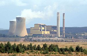
The Latrobe Valley is very important for Victoria's energy industry. It's where brown coal is mined and burned. This process creates electricity. The area makes about 85% of the electricity for Victoria. It also sends some electricity to New South Wales and Tasmania.
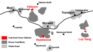
The valley has some of Australia's biggest power stations. These include Loy Yang Power Stations A & B and Yallourn Power Station. There's also the Jeeralang Power Station, which uses gas. Some older power stations, like Hazelwood and Energy Brix, have closed down.
How is the Latrobe Valley governed?
The local government for the Latrobe Valley is split between two councils. They are the Latrobe City Council and the Baw Baw Shire Council.
Latrobe City has about 75,000 people. Its main towns are Moe, Morwell, Churchill, and Traralgon. The main office for Latrobe City is in Morwell.
How do people get around?
The Princes Freeway runs through the Latrobe Valley. It connects the region to Melbourne and East Gippsland. Moe is about 1 hour and 30 minutes drive from Melbourne's city centre.
V/Line runs train services to the Latrobe Valley from Melbourne. Some trains stop at major towns like Warragul, Moe, Morwell, and Traralgon. Other services stop at all stations. The train line also connects to Melbourne's Pakenham line.
Latrobe Valley Bus Lines run bus services between Moe and Traralgon. They also connect to nearby towns like Morwell, Churchill, and Yallourn North. There are also local bus services within each major town.
The Latrobe Valley Airport (LTB) is near Traralgon. It's about two hours east of Melbourne.
Where do kids go to school?
The Gippsland campus of Federation University is in Churchill. It has about 2,000 students who study on campus. Many students from the Latrobe Valley and Gippsland attend this university.
The Gippsland Medical School is also in the area. It opened in 2008. It allows students to learn medicine in a rural setting.
What sports are popular?
Australian Rules Football
Australian Football is very popular here. Many players from the Latrobe Valley and Gippsland play in the Australian Football League. The region has a team called the Gippsland Power. They play in the Victoria State TAC Cup Under 18's competition. The Power won a championship in 2005. Over sixty players from Gippsland Power have gone on to play in the AFL.
Football leagues
The Gippsland Football League is the biggest league in the region. Five of its ten teams are from the Latrobe Valley. The Mid Gippsland Football League is also popular. All 10 of its teams are based in the Latrobe Valley. Most teams in the Gippsland Soccer League are also from the Latrobe Valley.
Racing Industry
The Moe Racing Club holds about fourteen horse races each year. The racecourse is very close to Moe's town centre and train station. The biggest races are the GPG Mobil Moe Cup in October and the Melbourne Cup Day meeting in November.
Glenview Park in Traralgon hosts both horse and greyhound racing. The first greyhound race there was in 1973.
Other sports
There are many golf courses in the Latrobe Valley. These include Moe Golf Club and Churchill & Monash Golf Club.
Many other sports are also popular. These include soccer, basketball, netball, gymnastics, tennis, swimming, baseball, and cricket.
How do people get news and entertainment?
Newspapers
The Latrobe Valley Express is a local newspaper. It is delivered for free to homes in the Latrobe Valley every Wednesday.
Radio
Several radio stations serve the area. These include Triple M Gippsland (94.3 and 97.9 MHz) and 3GG (531 kHz). TRFM (99.5 MHz) and Gold 1242 are based in Traralgon.
You can also hear ABC stations. These include the local ABC Gippsland (100.7 MHz) and national stations like Triple J (96.7 MHz).
Television
The Latrobe Valley was the first area in Australia to have its own regional TV station. This was GLV-10 Gippsland, which started in 1961.
You can watch programs from the main TV networks. These include Seven, Nine, and Ten. Their regional partners, Prime7, WIN, and Southern Cross Austereo, broadcast these shows. All these stations broadcast from Mount Tassie.
Local news is available on these channels. WIN has a half-hour WIN News show. Southern Cross Austereo and Prime7 show short local news updates.
The national public broadcasters, ABC and SBS, also broadcast here.
You can also get many extra digital channels. These are part of a service called Freeview. They include channels like ABC TV Plus, SBS Viceland, 10 Bold, 7two, and 9Gem.
 | Chris Smalls |
 | Fred Hampton |
 | Ralph Abernathy |


