Traralgon facts for kids
Quick facts for kids TraralgonVictoria |
|||||||||||||||
|---|---|---|---|---|---|---|---|---|---|---|---|---|---|---|---|
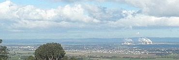
View south over the Traralgon urban area from Tyers lookout
|
|||||||||||||||
| Population | 26,907 (2021 census) | ||||||||||||||
| • Density | 1,125.8/km2 (2,916/sq mi) | ||||||||||||||
| Established | 1840s | ||||||||||||||
| Postcode(s) | 3844 | ||||||||||||||
| Elevation | 60 m (197 ft)(45-75m) | ||||||||||||||
| Area | 23.9 km2 (9.2 sq mi) | ||||||||||||||
| Location |
|
||||||||||||||
| LGA(s) | City of Latrobe | ||||||||||||||
| County | Australia | ||||||||||||||
| State electorate(s) | Morwell | ||||||||||||||
| Federal Division(s) | Gippsland | ||||||||||||||
|
|||||||||||||||
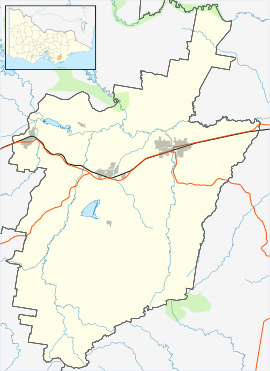
Traralgon is a city in the east of the Latrobe Valley in the Gippsland region of Victoria, Australia. It is the biggest and most populated city in the City of Latrobe area. In 2021, about 26,907 people lived in Traralgon. It is also the fastest-growing city in the wider Latrobe Valley, which has a population of 77,168 people.
Contents
- What's in a Name? The Story of Traralgon
- Traralgon's Past: A Look Back
- Traralgon's Location and Layout
- How Traralgon Makes Money
- Geothermal Energy: Heating with Earth's Warmth
- Learning in Traralgon: Schools and Colleges
- Sports and Fun in Traralgon
- Local News and Media
- Getting Around Traralgon
- Famous People from Traralgon
- See also
What's in a Name? The Story of Traralgon
The name Traralgon comes from an Indigenous name. It was first used for a large farming area in 1844. This area was owned by the Hobson brothers and was near Traralgon Creek.
Some people thought the name meant 'the river of little fish' in the local Indigenous language. However, experts who study the Gunai/Kurnai language say that the words for 'river', 'little', and 'fish' don't quite match up to form 'Traralgon'. So, the exact meaning of the name is still a bit of a mystery!
Traralgon's Past: A Look Back
Traralgon is on the traditional lands of the Indigenous Gunai/Kurnai nation. This includes the Braiakaulung clan, who lived north of the Latrobe River, and the Woollum-Woollum clan, who lived south of the river.
Ancient Tools and Life
The Gunai/Kurnai people made stone tools about 5,000 years ago. They used special rocks from quarries in the Haunted Hills, west of Morwell. You can still find scarred trees and rock sites with grooves where they sharpened their axes. Evidence shows that Indigenous people have lived in the Gippsland region for more than 20,000 years.
Early Explorers and Guides
The first non-Indigenous visitors came to the Traralgon area in April 1840. This group was led by Count Paweł Strzelecki. They were on a journey from the Snowy Mountains. Their Indigenous guide was Charley Tarra, a brave man from New South Wales.
The group crossed the Latrobe River and followed Traralgon Creek. They had to leave their horses and equipment in a very thick forest. A monument was built in 1927 to remember this spot. The team ran out of food, but Charley Tarra hunted animals to feed them. They eventually reached Western Port and then walked to Melbourne.
To honor these explorers, a mountain range was named the Strzelecki Ranges. Part of the forest became Tarra Valley, now part of Tarra-Bulga National Park. The river flowing from the valley was named Tarra River. Strzelecki also named the whole region Gipps' Land, which later became Gippsland, after the Governor of New South Wales, George Gipps.
First Farms and Settlements
European settlers first came to the Traralgon area in the 1840s. The land was very good for farming because it had a lot of rain. Dairy farming quickly became popular. Between 1840 and 1860, the number of settlers grew, while the Gunai population sadly decreased.
The Hobson brothers were the first Europeans to claim land in Traralgon in 1844. They bought a large farming area of 19,000 acres.
Traralgon Becomes a Town
Traralgon officially became a township in the early 1860s. The first Post Office opened on 1 January 1861. In 1877, the Gippsland railway line from Melbourne was finished. This brought a railway station to Traralgon, which helped the town grow a lot.
Traralgon started to change from a farming town in the 1930s. In 1939, a paper mill was built nearby at Maryvale. This created many jobs for local people.
Royal Visit and City Status
Queen Elizabeth II and Prince Philip, Duke of Edinburgh visited Traralgon on 3 March 1954. The Queen was welcomed by the local leader, Cr Clem Little.
In 1961, Traralgon became its own borough, separate from the surrounding rural area. It was then officially declared a city in 1964.
Growth and Changes
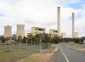
After World War II, the power generation industry grew a lot. This led to big power stations like Yallourn, Hazelwood, and Loy Yang Power Station being built. These projects brought more jobs and development to the area.
In the early 1990s, an information processing center for the Australian Securities & Investments Commission opened. It employed about 400 people.
In 1994, the City of Traralgon joined with the Shire of Latrobe to form the larger City of Latrobe.
When the power stations were finished and the electricity industry changed, it affected the economy of the Latrobe Valley. Traralgon was less affected than nearby towns like Morwell and Moe, because Traralgon had a wider range of businesses.
Traralgon grew quickly in the mid-2000s, becoming the largest and fastest-growing city in the Latrobe Valley.
Historic Places in Traralgon
Traralgon has several places that are protected because of their history:
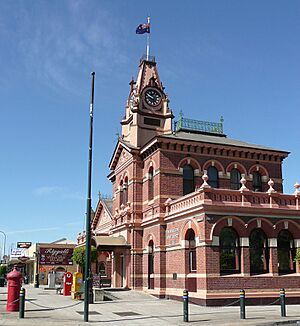
- 161-165 Franklin Street: Traralgon Post Office and Court House
- Queens Parade: Traralgon Engine Shed and Turntable
- Victory Park, Mill Street: Azarole Hawthorn Tree
Traralgon's Location and Layout
Traralgon is on flat land in the Traralgon Creek valley. It's located between the Great Dividing Range to the north and the Strzelecki Ranges to the south. Traralgon Creek flows through the city, creating a green area that separates the eastern and western parts of town.
City Structure
Traralgon is part of the Latrobe Valley's three main cities, which also include Morwell and Moe. Traralgon and Morwell together form an urban area with about 41,984 people (as of June 2018).
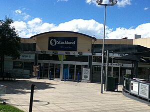
The main shopping and business area of Traralgon is around Seymour and Franklin Streets. The Traralgon Centre Plaza is an indoor shopping mall that opened in 1985. You can also find shops and light industries along the Princes Highway. Important historic buildings include the Post Office and Courthouse (built in 1886) and Ryans Hotel (built in 1914).
Weather in Traralgon
Traralgon has an oceanic climate, which means it has mild temperatures and rain throughout the year. Nights in Traralgon are usually about 2°C colder than in Melbourne.
In June 2021, Traralgon was hit hard by a big storm. This caused widespread flash flooding, and about 200 homes had to be evacuated.
How Traralgon Makes Money
Traralgon's economy relies a lot on its natural resources and industries.
Key Industries
- Energy: A major part of the economy comes from coal mining and making electricity from fossil fuels. This electricity is sent to the National Electricity Market. Traralgon also benefits from oil and natural gas found in the nearby Bass Strait.
- Forestry: There's a big forestry industry here, including logging from tree plantations and natural forests. The largest paper mill in Australia is in Maryvale, close to Traralgon. It employs over 2,000 people.
- Agriculture: Local farms produce wool and dairy products. They also grow vegetables.
Government and Services
Many people also work in the service industry, especially for government offices. These include departments like the Australian Securities & Investments Commission and the Department of Health & Human Services.
Geothermal Energy: Heating with Earth's Warmth
The Gippsland Regional Aquatic Centre in Traralgon uses a special heating system. It's the first public swimming center in Victoria to use deep-bore geothermal heating. This system uses warm water from deep underground, more than 600 meters down. The water there is about 65 degrees Celsius!
Learning in Traralgon: Schools and Colleges
Traralgon has many schools, including primary and secondary schools. There are state schools, Catholic schools, and independent schools.
Primary Schools
Some primary schools include Grey Street Primary School, Kosciuszko Street Primary School, Liddiard Road Primary School, Stockdale Road Primary School, St Michaels Primary School, St Gabriels Primary School, Chairo Christian School, and St Pauls Anglican Grammar School. The Latrobe Special Developmental School helps students aged 4.5 to 18 with intellectual and physical disabilities.
Secondary Schools
The local government secondary school is Traralgon College. It has two campuses: a junior campus for years 7 and 8, and a senior campus for years 9-12. There's also a Catholic secondary school called Lavalla Catholic College, which has two campuses in Traralgon. St Paul's Anglican Grammar School and Chairo Christian School also offer secondary education.
Higher Education
For older students, Federation University Australia's Gippsland Campus is just a 15-minute drive away in Churchill. Traralgon also has a campus for TAFE Gippsland, which offers vocational training.
Sports and Fun in Traralgon
Traralgon is a great place for sports!
Team Sports
- Australian Rules Football: This sport is very popular. There are two senior clubs: the Traralgon Maroons and Traralgon-Tyers United. There's also a junior league for younger players.
- Cricket: There's a local league called the Traralgon and District Cricket Association (TDCA).
- Soccer: Two clubs, Traralgon City and Traralgon Olympians, play in the Latrobe Valley Soccer League.
- Basketball: The Traralgon Basketball Association has a stadium at the Traralgon Sports Complex. This stadium even hosted games for the 2006 Commonwealth Games!
- Baseball: The local team is the Traralgon Redsox.
Other Sports
- Horse Racing: The Latrobe Valley Racing Club holds horse races twice a year.
- Greyhound Racing: The Traralgon Greyhound Racing Club has regular greyhound races.
- Golf: Golfers can play at the Traralgon Golf Club.
- Running: The Traralgon Harriers running club has races every Thursday night. They also organize Victoria's oldest marathon, the Traralgon Marathon, every June.
- Cycling: The Latrobe Valley Cycling club holds road and track racing events.
- Shooting: Traralgon Pistol Club and Traralgon Small Bore Rifle Club are also in town.
Entertainment
The entertainment area around Kay, Grey, and Franklin Streets has nightclubs, bars, and restaurants. People from nearby towns often come here for fun.
Local News and Media
Newspapers
The weekly Latrobe Valley Express newspaper is delivered to homes in Traralgon, Morwell, and Moe. Older copies of the Traralgon Record newspaper from 1886 to 1932 can be found online. You can also buy major newspapers from Melbourne and across Australia.
Television
Traralgon was the first place in Australia to have its own regional television station, GLV-10 Gippsland, which started in 1961.
Today, you can watch programs from the three main commercial TV networks (Seven, Nine, and Ten). These are re-broadcast into the Latrobe Valley from a transmitter at Mount Tassie. All these stations are based in Traralgon and show local commercials.
You can also watch local news:
- WIN broadcasts a half-hour WIN News every weekday evening.
- Southern Cross Austereo and Seven show short local news and weather updates throughout the day.
The national public broadcasters, ABC and SBS, are also available. You can also get many extra digital channels through a service called Freeview.
Radio
Traralgon has two local radio stations: TRFM (99.5 MHz) and Gold 1242. Many ABC stations are also available, including the local ABC Gippsland station (100.7 MHz).
Community radio stations like Gippsland FM (104.7 MHz) from Morwell and Life FM (103.9 MHz) from Sale can also be heard in Traralgon.
Getting Around Traralgon
Roads
Most people in Traralgon use cars to get around. The Princes Highway runs through the city, close to the main business area. The Hyland Highway also starts in Traralgon.
Trains
Traralgon has a train station on the Gippsland railway line. V/Line trains travel from Melbourne to Bairnsdale, stopping in Traralgon. You can use the Myki electronic ticketing system for train travel.
Buses and Cycling
Latrobe Valley Buslines provides local bus services within Traralgon and to other cities in the Latrobe Valley.
Traralgon has some bike paths. The 63-kilometer-long Gippsland Plains Rail Trail connects Traralgon to Stratford. A new path for cycling and walking opened in 2020, connecting Traralgon to Morwell and the Latrobe Regional Hospital.
Airport
The Latrobe Valley Airport is near Traralgon in Morwell. It is used for general aviation.
Famous People from Traralgon
|
Sports Stars
|
Other Notable People
|
See also
 In Spanish: Traralgon para niños
 | James Van Der Zee |
 | Alma Thomas |
 | Ellis Wilson |
 | Margaret Taylor-Burroughs |


