Morwell facts for kids
Quick facts for kids MorwellVictoria |
|||||||||||||||
|---|---|---|---|---|---|---|---|---|---|---|---|---|---|---|---|

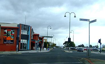
Corner of Hazelwood and Commercial Roads, Morwell
|
|||||||||||||||
| Population | 14,389 (2021 census) | ||||||||||||||
| Established | 1870s | ||||||||||||||
| Postcode(s) | 3840 | ||||||||||||||
| Elevation | 80 m (262 ft) | ||||||||||||||
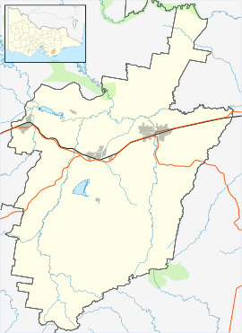
| Location |
|
||||||||||||||
| LGA(s) | City of Latrobe | ||||||||||||||
| State electorate(s) | Morwell | ||||||||||||||
| Federal Division(s) | Gippsland | ||||||||||||||
|
|||||||||||||||
Morwell is a town in the Latrobe Valley region of Gippsland, located in south-eastern Victoria, Australia. It is about 152 kilometres (94 miles) east of Melbourne. In 2021, Morwell had a population of 14,389 people.
Morwell is the main administrative centre for the City of Latrobe. It is also the second largest town in the city, after nearby Traralgon. Morwell is in the middle of the Latrobe Valley urban area, which has a population of 77,168. Many important public buildings and services for the wider area are found here.
The town is well-known for its role in producing energy for Victoria. It is a major centre for coal mining and power generation. Morwell also has a beautiful Centenary Rose Garden in its town centre. This garden won an award in 2009 for being a 'garden of excellence'. Since 2018, Morwell has hosted the International Rose Garden Festival.
Contents
Understanding the Name of Morwell
The name Morwell likely comes from a word in the Gunai language. This Indigenous word means inhabitants of the swamp. It referred to the Gunai clan who lived in this area. The nearby town of Moe also got its name from a Gunai word meaning swampland. This refers to a swamp between Moe and Yarragon that was drained in the 1890s.
Some newspaper articles from 1914 suggested that Morwell's name came from Aboriginal words more willie, meaning woolly possum. However, the Gunai word for possum is wadthan. The words wile or wollert come from the Kulin language, specifically Woiwurrung. The Kulin nation's traditional lands are west of Warragul, which is about 50 kilometres (31 miles) west of Morwell. This makes it unlikely that the name came from a Kulin language. The town of Wollert, Victoria is named after this word for possum.
The Morwell River was the first place to be named Morwell. In 1847, explorer Charles Tyers wrote it as Morewill River in his diary. An 1847 map showed it as Morewell River. In 1848, it was called River Morewelle. Peter Jeremiah Smith opened the Morewell Hotel on the river in 1858. The early settlement around the hotel was called Morwell Bridge in 1861. The name Morwell was later used for the new town centre. This new centre grew around the Morwell railway station after it opened in 1877.
In 1942, a station worker named Llew Vary thought the name Morwell came from an English town. He believed it was named after Morwell in Cornwall, England. However, he had no proof. In 1946, members of the Morwell Rotary Club and Methodist Church explored this idea further. Historian Ivan Maddern strongly supported it from 1962. Methodist ministers in Australia contacted their counterparts in England. They learned about Morwellham on the River Tamar, a cliff called Morwell Rocks, Morwell Barton, and Morwell Priory.
Another idea is that 'Morewell' came from 'Mary Ville'. This was the first name of the Maryvale pastoral farm, set up in 1845. It was thought to be named after Mary, the daughter of the Bennetts. The Bennetts started the Hazelwood station with Albert Brodribb. However, the Morwell Historical Society found that 'Morewell' was first recorded in 1844.
Morwell's Rich History
The first people to live in the Morwell area were the Braiakaulung people. They are one of the five Indigenous Australian clans of the Gunai/Kurnai nation. The Braiakaulung people made stone tools from quarries in the Haunted Hills, west of Morwell. They did this as long as 5,000 years ago. The Gunai/Kurnai people have lived in the region for over 20,000 years. Evidence for this was found at the New Guinea II cave near Buchan, Victoria.
The first Europeans to travel through the area included Count Paweł Strzelecki and his group. They journeyed from the Snowy Mountains in April 1840. Strzelecki had named Australia's highest peak, Mount Kosciuszko. In 1838, Scottish farmer Angus McMillan rode horses up the Latrobe River near Sale. He did not go as far as Morwell at that time. He made more trips to the Latrobe River after Strzelecki's visit. McMillan called the region 'Caledonia Australis'. But the name 'Gipps Land' became more popular. Strzelecki chose this name to honour New South Wales Governor George Gipps. It later became Gippsland.
The first Europeans to claim land in Morwell were called squatters. They ran large farms known as pastoral leases. These included the 17,300-acre Hasellwood (later Hazelwood). Albert Eugene Brodribb and William Bennett started it in October 1844. The 22,900-acre Mary Ville (later Maryvale) was started by Thomas Gorringe in February 1845. The 24,780-acre Merton Rush station was started by Henry Scott in 1846. The 5,730-acre Scrubby Forest was started by Nicol Brown and William Hunter in 1848.
The 1870s was a time when many railways were built in Victoria. In 1873, the government approved building a railway line from Melbourne to Sale. This decision helped the town of Morwell grow. The new railway station was about 5 kilometres (3 miles) from the old settlement by the river. This led to new buildings and businesses growing around the railway station.
The first public sale of land in the town happened in January 1879. But at least ten businesses were already operating there by then. A Post Office in the town had been open since 1875. An earlier Post Office served the rural area from 1870 to 1873. On January 1, 1880, the Morwell Post Office was renamed Morwell Bridge. The Morwell Railway Station Post Office, which opened in 1877, became the main Morwell Post Office.
A big research project started in Morwell in 1983-1984. It was called Brown Coal Liquefaction Victoria (BCLV). This project aimed to turn brown coal into oil. The Japanese Government funded it with over a billion dollars. A pilot plant was built that could process 50 tonnes of coal per day. This plant operated until 1991.
Morwell grew because of the successful power industry. It offered many homes and financial chances for its residents. As the Latrobe Valley grew, Morwell seemed set to keep succeeding. However, the City of Morwell allowed the Mid Valley Shopping Centre to be built away from the main town centre. This led to the decline of the central business district (CBD). Many shops became empty. Also, the State Electricity Commission was reorganised and privatised in the 1990s. This caused many job losses in the region. It made the decline of Morwell's CBD even faster. Many shops are now empty and in poor condition.
In 1994, local councils were combined after a review of local government areas. Morwell became part of the City of Latrobe. The main civic centre was first moved to Traralgon. But when an elected council was re-established, the civic centre moved back to Morwell. A new council building was built in 2005. It was hoped this would help the city centre become lively again. Unfortunately, this did not happen. A new justice precinct was finished in 2006. This has brought some activity to the CBD.
Figures from the Australian Bureau of Statistics in March 2011 showed that Morwell residents had the lowest average wage among the three main Latrobe Valley towns.
Morwell is home to the Central Gippsland Institute of Technical and Further Education. It has a major regional art gallery with a great local art collection. It is also famous for its large rose gardens. Nearby in Churchill is the Gippsland Campus of Federation University. A statue of Lt Gen Sir Stanley Savige was put up in 2006. Savige was born in Morwell. He founded Legacy Australia after World War 1 to help widows and families of servicemen.
Morwell is home to the Morwell Centenary Rose Garden. This park covers over 2 hectares (5 acres) and has more than 3500 roses. It is on a former railway area. In 2009, the World Federation of Rose Societies gave the garden an 'Award of Garden Excellence'.
Morwell's Climate and Weather
Morwell has an oceanic climate, which means it has mild temperatures. Nights in Morwell are usually about 2°C colder than in Melbourne.
| Climate data for Morwell (Latrobe Valley Airport, 1984–2020); 56 m AMSL; 38.21° S, 146.47° E | |||||||||||||
|---|---|---|---|---|---|---|---|---|---|---|---|---|---|
| Month | Jan | Feb | Mar | Apr | May | Jun | Jul | Aug | Sep | Oct | Nov | Dec | Year |
| Record high °C (°F) | 45.1 (113.2) |
46.3 (115.3) |
40.4 (104.7) |
35.0 (95.0) |
26.7 (80.1) |
23.5 (74.3) |
21.8 (71.2) |
26.8 (80.2) |
31.0 (87.8) |
35.1 (95.2) |
38.6 (101.5) |
42.2 (108.0) |
46.3 (115.3) |
| Mean daily maximum °C (°F) | 26.2 (79.2) |
26.5 (79.7) |
24.4 (75.9) |
20.5 (68.9) |
16.9 (62.4) |
14.2 (57.6) |
13.6 (56.5) |
14.9 (58.8) |
16.9 (62.4) |
19.3 (66.7) |
21.6 (70.9) |
24.0 (75.2) |
19.9 (67.8) |
| Mean daily minimum °C (°F) | 12.5 (54.5) |
12.7 (54.9) |
11.1 (52.0) |
8.5 (47.3) |
6.6 (43.9) |
4.4 (39.9) |
3.7 (38.7) |
4.3 (39.7) |
5.8 (42.4) |
7.4 (45.3) |
9.4 (48.9) |
11.1 (52.0) |
8.1 (46.6) |
| Record low °C (°F) | 1.8 (35.2) |
1.9 (35.4) |
1.9 (35.4) |
−0.5 (31.1) |
−2.6 (27.3) |
−3.6 (25.5) |
−4.8 (23.4) |
−3.4 (25.9) |
−2.1 (28.2) |
−2.3 (27.9) |
0.6 (33.1) |
1.7 (35.1) |
−4.8 (23.4) |
| Average precipitation mm (inches) | 50.1 (1.97) |
39.2 (1.54) |
43.9 (1.73) |
57.1 (2.25) |
51.6 (2.03) |
58.4 (2.30) |
66.4 (2.61) |
62.9 (2.48) |
78.4 (3.09) |
72.8 (2.87) |
75.0 (2.95) |
68.6 (2.70) |
724.4 (28.52) |
| Average precipitation days (≥ 0.2 mm) | 9.5 | 8.7 | 10.9 | 13.1 | 15.7 | 18.3 | 19.1 | 19.0 | 16.9 | 14.8 | 13.3 | 12.1 | 171.4 |
| Average afternoon relative humidity (%) | 46 | 46 | 48 | 55 | 64 | 68 | 67 | 61 | 59 | 56 | 54 | 49 | 56 |
How Morwell is Governed
Morwell is governed at a local level by the City of Latrobe. It is the main administrative centre for the city. Morwell is represented by two councillors in the Central Ward.
In the Victorian Government, Morwell is represented in the Victorian Legislative Assembly by the Electoral district of Morwell. The state government is responsible for law and order in Morwell. The Latrobe Valley Law Courts are located opposite the council headquarters. They have branches for the Supreme Court of Victoria, Magistrates' Court of Victoria, and County Court of Victoria. Morwell also has a single Victoria Police police station.
In the Government of Australia, Morwell is represented in the Parliament of Australia by the Division of Gippsland.
Learning and Education in Morwell
Morwell offers many education options, from preschool education to vocational education and training. University degrees are available nearby at Federation University Australia, Gippsland campus. This campus is in the neighbouring town of Churchill. Other education providers are in the wider Latrobe Valley area.
Morwell has four primary schools:
- Morwell Central Primary School
- St Vincent De Paul Primary
- Sacred Heart Primary
- Morwell Park Primary
There is one junior secondary school:
- Kurnai College Morwell Campus (established 1963)
For further education, you can study at TAFE Gippsland (formerly GippsTAFE). You can also find apprenticeships and traineeships through Apprenticeships Group Australia.
Getting Around Morwell
The Princes Freeway (A1) goes around the south of the town. The old Princes Highway, which used to go through the town, is now called Princes Drive and Commercial Road. This highway connects Morwell to other Latrobe Valley cities. These include Moe to the west and Traralgon to the east. Another important road is the Strzelecki Highway (B460), which runs south towards Leongatha.
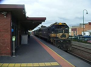
For train travel, Morwell has both passenger rail and freight rail services. The town's only station is Morwell railway station. It is on the Bairnsdale line. Both the Traralgon V/Line rail service and the Bairnsdale V/Line rail service stop here. Trains run hourly in both directions. A trip to Melbourne takes about 109 minutes during busy times.
For air travel, General aviation flights operate from Latrobe Regional Airport. This airport serves the entire Latrobe Valley urban area.
Sports and Recreation in Morwell
Australian rules football is very popular in Morwell. There are two main clubs in the town:
- The Morwell Football Club (established 1905) plays at the Morwell Recreation Reserve. They compete in the Gippsland Football League.
- The Morwell East Football Club (established 1973) plays at the Morwell East Football Ground. They compete in the Mid Gippsland Football League.
The Morwell Football Ground is also home to the Gippsland Power (established 1993). This team plays in the TAC Cup. The ground has also hosted Australian Football League pre-season matches in 2005 and 2010.
Cricket is also popular. There are two senior cricket clubs: Morwell and Latrobe. Famous cricketer Peter Siddle played for Latrobe when he was younger.
Soccer has a long history in Morwell. The Morwell Falcons were formed in 1961. They even reached the National Soccer League, which was Australia's top league. The club stopped playing in 2001. However, a new club called Falcons 2000 was formed. It continues the legacy of the original club. This club plays in the Latrobe Valley Soccer League. This is the eighth level of soccer in Victoria, and the ninth nationally. The club's home ground is Latrobe City Stadium.
Other soccer clubs, Fortuna 60 and Morwell Pegasus, also play in the same league as the Falcons 2000. Their home grounds are Crinigan Road South Reserve and Ronald Reserve.
The Morwell Cougars Baseball Club usually has teams in three senior grades. They also have teams in all junior grades of the Latrobe Valley League. Their fields in Toners Lane are the only dedicated baseball fields in the League.
American Football is played at Maryvale Recreation Reserve. This is also the home of the local club Gippsland Gladiators. They have been based there since 2010. They compete in Division 2 of the Gridiron Victoria league.
Morwell also has a 25-metre indoor swimming pool. The local swimming club uses it for competitive swimming.
Golfers can play at the Morwell Golf Club on Fairway Drive.
Media and Local News
Commercial radio stations that serve Morwell and the wider Gippsland region include:
- 531 3GG
- 94.3/97.9 Triple M Gippsland
- 99.5 TRFM
- Gold 1242
The national public broadcaster ABC Gippsland broadcasts on 100.7FM. Community station Gippsland FM (formerly 3GCR) broadcasts on 104.7FM.
Gippsland FM is the only radio station in the region with a studio complex located in Morwell.
Famous People from Morwell
Many notable people have come from Morwell, including:
- Paul Abbott, AFL Footballer
- Ben Ainsworth, AFL Footballer
- Veronica Gorrie, Aboriginal Australian writer
- John Hutchinson, Coach and former Soccer player
- Changkuoth Jiath, AFL Footballer
- Chips Mackinolty, Radical poster artist and journalist
- Rocky Mattioli, Italian–Australian World Champion Boxer
- Paul Morris, Motor racer
- Bryan Quirk, footballer
- Peter Siddle, Cricketer
- Cathie Reid, businesswoman
- Archie Thompson, footballer
- John Trevorrow, Australian champion Road cyclist
- Vin Waite, footballer
- Ricky Harrison, Aboriginal Musician
- Nicky Moffatt, Aboriginal Musician
 | Jessica Watkins |
 | Robert Henry Lawrence Jr. |
 | Mae Jemison |
 | Sian Proctor |
 | Guion Bluford |


