Mulga Lands facts for kids
Quick facts for kids Mulga LandsEastern Australia mulga shrublands |
|
|---|---|

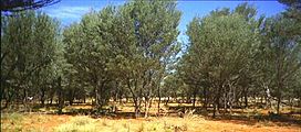
Mulga lands in South west Queensland
|
|

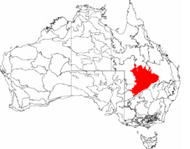
Map of IBRA bioregions, with Mulga Lands in red
|
|
| Ecology | |
| Realm | Australasian |
| Biome | temperate grasslands, savannas, and shrublands |
| Borders |
List
|
| Geography | |
| Area | 251,883 km2 (97,253 sq mi) |
| Country | Australia |
| States | New South Wales and Queensland |
| Coordinates | 28°06′S 145°41′E / 28.100°S 145.683°E |
| Conservation | |
| Conservation status | vulnerable |
| Protected | 9,662 km² (4%) |
The Mulga Lands are a large natural area in eastern Australia. This bioregion is made up of dry, sandy plains. It has many low woodlands and shrublands. These areas are mostly covered by Acacia aneura trees, which are commonly called mulga. The Eastern Australia mulga shrublands is another name for this same natural area.
Contents
Where are the Mulga Lands?
The Mulga Lands are found in inland New South Wales and Queensland. They are mostly flat plains, but some low hills can be found. The soil here is sandy and not very fertile. It has a mix of grasses, shrubs, and mulga and eucalyptus trees.
Wetlands and Rivers
This region also has wetlands. Most of these wetlands only fill with water during certain seasons. Important wetlands include Lake Wyara, Lake Numalla, and Lake Bindegolly. These lakes are connected to rivers like the Warrego River and the Paroo River. The Paroo River is special because it is still very natural and not managed by people.
Climate and Water Sources
The Mulga Lands have a very dry climate. Rainfall is low and hard to predict, usually between 450mm and 650mm each year. Water from the plains flows in three main directions. To the east, it goes into the Murray-Darling Basin. To the southwest, it flows into wetlands near the Simpson Desert. To the north, it goes towards Lake Eyre.
Underneath these plains is the Great Artesian Basin. This is a huge underground water source. You can find more wildlife around special "mound springs" that come from this basin.
Neighboring Regions
The Mulga Lands are unique because of their plants and poor soil. They are different from the Brigalow Belt to the east and the Mitchell Grass Downs to the north. Those areas have better soil and more diverse plant life. To the south and southeast is the Southeast Australia temperate savanna. The very dry Simpson Desert and Tirari-Sturt stony desert are to the west.
Not many people live in the Mulga Lands. Most of the land is used for grazing sheep and cattle.
Plants of the Mulga Lands (Flora)
Mulga trees are a type of acacia tree. They are very good at collecting the small amounts of rainfall. These trees are the main plant life in this area. The ground beneath them is covered with shrubs and grasses.
However, the Mulga Lands are not the same everywhere. There are small areas with different climates and habitats. For example, some parts have eucalyptus woodlands, especially where there is more water. These areas have more wildlife than the mulga plains.
Types of Eucalyptus Trees
Some eucalyptus trees found here include bimble box, coolibah, and silver-leaved ironbark. East of the Warrego River in Queensland, the mulga lands change into sand dunes with heath plants. After it rains, plants in the Mulga Lands grow quickly, and the habitats come alive.
Animals of the Mulga Lands (Fauna)
The Currawinya National Park is working to help the bilby population grow in Australia. In the park, bilbies are safe from dingos and cats.
Birdlife in Wetlands
This part of Australia is usually dry. But when Lakes Wyara and Numalla are flooded, they become very important places for birds. These lakes can be home to 250,000 birds from 40 different species.
Some of the birds you might see include the rainbow bee-eater, Australasian shoveller, freckled duck, musk duck, black swan, silver gull, Australian pelican, great egret, and glossy ibis.
Protecting the Mulga Lands (Conservation)
About 80% of the original plant cover in the Mulga Lands is still healthy. This is especially true in the drier western parts. Some eucalyptus woodlands in the eastern areas have been cleared. Luckily, there are no endangered habitats in the Mulga Lands right now.
Threats to the Environment
Most of this area is used for grazing sheep and cattle. This means there is always a risk of overgrazing. Overgrazing happens when too many animals eat too much of the plants. Mulga leaves are also used to feed livestock. Other trees are sometimes removed to create more grassland for animals or to get to water sources. The special mound springs are particularly affected by these activities.
National Parks and Protected Areas
There are several National Parks in the Mulga Lands that help protect the environment. The largest one is Currawinya National Park, where the wetlands are very important for birds. Other protected areas include Hell Hole Gorge, Lake Bindegolly, Mariala, Thrushton, part of Welford, Idalia, and the Culgoa Floodplain National Parks.
See also
 In Spanish: Tierras de Mulga para niños
 | Valerie Thomas |
 | Frederick McKinley Jones |
 | George Edward Alcorn Jr. |
 | Thomas Mensah |

