
Cobar facts for kids
Quick facts for kids CobarNew South Wales |
|||||||||
|---|---|---|---|---|---|---|---|---|---|

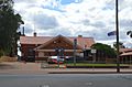
Marshall Street, the main street of Cobar. Cobar retains much of its late 19th-century architecture.
|
|||||||||

Cobar
Location in New South Wales
|
|||||||||
| Population | 3,990 (2016 census) | ||||||||
| Established | 1870 | ||||||||
| Postcode(s) | 2835 | ||||||||
| Elevation | 260 m (853 ft) | ||||||||
| Location |
|
||||||||
| LGA(s) | Cobar Shire | ||||||||
| County | Robinson | ||||||||
| State electorate(s) | Barwon | ||||||||
| Federal Division(s) | Parkes | ||||||||
|
|||||||||
Cobar is a town in central western New South Wales, Australia. Its main industry is mining for metals like copper and gold. The town is about 712 kilometres (442 miles) northwest of Sydney, the state capital.
Cobar is located where the Kidman Way and Barrier Highway meet. It sits on the eastern edge of the Australian outback. In 2016, Cobar had a population of 3,990 people. The wider Cobar Shire area has about 4,700 people and covers a huge area of 44,065 square kilometres (17,014 square miles).
Many interesting places can be found in and around Cobar. The town still has many buildings from the late 1800s. The ancient Aboriginal rock paintings at Mount Grenfell are some of Australia's largest and most important. The new Cobar Sound Chapel opened in April 2022.
Contents
History of Cobar
First Peoples
The Cobar area is the traditional home of the Wongaibon people. They are part of the Ngiyampaa language group. The name ‘Cobar’ comes from a Ngiyampaa word, like kubbur or kuparr. It means a waterhole and a place where special coloured earths were dug up. These earths, like ochre and copper minerals, were used for ceremonial body paint.
Mount Grenfell Historic Site is northwest of Cobar. It was an important meeting place for ceremonies. The site has many rock paintings made with ochre and clay. They show human and animal figures, and hand stencils.
Early European Settlers
In the 1850s, European settlers started sheep and cattle farms along the Darling River. The Cobar area was very dry, with little water. By the mid-1860s, some farms called ‘back stations’ were set up near Cobar. They built tanks and wells to get water for their animals.
Copper Discovery
In 1870, three well-sinkers, Charles Campbell, Thomas Hartman, and George Gibb, were travelling through the area. Two Aboriginal guides, Frank and Boney, showed them to the Kubbur waterhole. The men noticed green and blue stains on the rocks. They collected some samples.
Later, they showed the rocks to Sidwell Kruge, whose family had mined copper in South Australia. She knew the rocks contained copper. Her husband melted some samples, confirming it. The three men then claimed the land around the waterhole.

Soon, the Cobar Copper Mining Company was formed. In 1871, shares in the company were very popular. People thought the Cobar mine would be one of Australia's richest copper mines.
By 1875, furnaces were built to melt the copper ore. The Cobar Copper Mining Company and the South Cobar Mining Company joined together. They formed the Great Cobar Copper Mining Company Ltd. Many miners, especially from Cornwall, England, came to Cobar to work.
Gold Mining
Cobar is famous for copper, but it also had important gold mines. The Chesney Mine was one of the first big gold producers. The New Occidental Mine became New South Wales's most productive gold mine. Gold was also found when copper was refined at the Great Cobar refinery in Lithgow.
Cobar Town Life
By 1881, Cobar was a large mining town with about 2,500 people. It had different parts: the Government Township, the Private Township (where the mine company owned land), and Cornish Town. Most shops and public buildings were in the Private Township.
A big problem for Cobar was the lack of water. People often worried about running out. They relied on rain-filled tanks for water.
By 1888, Cobar had many solid buildings, some made of brick. It had a courthouse, a jail, nine hotels, and two banks. The town grew thanks to the Great Cobar Copper Mine and the surrounding farms.
Several beautiful old buildings from the late 1800s are still standing. These include the Great Western Hotel (1898), which has a very long verandah. Also, the Cobar Post Office (1885), the Cobar Court House (1887), and the Cobar Heritage and Visitor Information Centre (1910) are important.
At its busiest, Cobar had 10,000 people. It was a centre for smaller mining villages nearby. But by the early 1920s, most mines closed. The Great Cobar mine closed in 1919. Other mines followed, and the town's future looked uncertain.
However, the old Occidental gold mine reopened in 1933. This helped save the town. Copper mining started again in 1965. In the 1980s, more gold, silver, lead, and zinc were found. This led to more people moving to Cobar.
Today, mining is still very important to Cobar's economy. You can visit mine sites through the Cobar Heritage and Visitor Information Centre. The Festival of the Miners' Ghost is held every October. It celebrates the spirits of the old miners.
Cool Places to See
Cobar has several places listed for their historical importance:
- Cobar railway station: Part of the old railway line.
- Cobar Post Office: A historic building at 47 Linsley Street.
- Cobar Visitor's Centre / Great Cobar Heritage Centre: Also known as the Mining Administration Offices, a former mine office.
The New Occidental Hotel was a pub built in 1879. It was a popular spot for miners and local groups. In 2014, a fire damaged the building.
People of Cobar
| Historical population | ||
|---|---|---|
| Year | Pop. | ±% |
| 1921 | 1,437 | — |
| 1933 | 1,163 | −19.1% |
| 1947 | 2,039 | +75.3% |
| 1954 | 2,224 | +9.1% |
| 1961 | 2,178 | −2.1% |
| 1966 | 2,350 | +7.9% |
| 1971 | 3,756 | +59.8% |
| 1976 | 3,339 | −11.1% |
| 1981 | 3,583 | +7.3% |
| 1986 | 4,287 | +19.6% |
| 1991 | 4,138 | −3.5% |
| 1996 | 4,524 | +9.3% |
| 2001 | 4,105 | −9.3% |
| 2006 | 4,128 | +0.6% |
| 2011 | 3,817 | −7.5% |
| 2016 | 3,748 | −1.8% |
| 2021 | 3,369 | −10.1% |
| Source: Australian Bureau of Statistics data. | ||
In the 2016 census, Cobar had 3,990 people.
- About 11.8% of the people were Aboriginal and Torres Strait Islander.
- Most people (78.5%) were born in Australia.
- Most people (83.4%) spoke only English at home.
- The most common religions were Catholic (33.8%), No Religion (18.9%), and Anglican (17.1%).
Famous People from Cobar
- Lilliane Brady: A mayor for over 20 years, she was the longest-serving female mayor in New South Wales history.
- Nik Kosef: A former professional rugby league player. He played for the Manly-Warringah Sea Eagles and represented NSW and Australia.
- Robert William Rankin: A naval commander. A submarine, HMAS Rankin (SSG 78), was named after him.
- Ernie Toshack: A famous cricketer, part of the "Invincibles" team.
- Dora Birtles: A novelist and writer.
- Muriel O'Malley: An opera singer and musical theatre actress.
Cobar's Economy
Cobar's economy relies a lot on its mines and the people who work there. This means it can change depending on world metal prices. For example, in 2008, when zinc prices dropped, one mine cut many jobs. This affected other businesses in town.
Cobar is also the centre for the local government area. The town has two primary schools, a high school, a youth centre, and a hospital.
Cobar Quid
Cobar has its own local money called Cobar Quid. It was started in 2003 by the Cobar Business Association. This special money encourages people to shop at local businesses.
The Cobar Quid comes as minted medallions in values of $5, $10, $20, and $50. The Royal Australian Mint makes them. Businesses can exchange the medallions for regular cash through the Cobar Shire Council.
Cobar's Weather
Cobar has a hot semi-arid climate. This means it has long, very hot summers and short, cool winters. It doesn't get much rain, but the rain is spread out through the year. It's a very sunny place, with over 3,200 hours of sunshine each year.
The hottest temperature ever recorded in Cobar was 47.8 degrees Celsius (118 degrees Fahrenheit). The coldest was -6.7 degrees Celsius (20 degrees Fahrenheit).
| Climate data for Cobar (31º32'S 145º48'E, 218−260 AMSL) (1993−2024, extremes to 1881, sunshine 1978−2010) | |||||||||||||
|---|---|---|---|---|---|---|---|---|---|---|---|---|---|
| Month | Jan | Feb | Mar | Apr | May | Jun | Jul | Aug | Sep | Oct | Nov | Dec | Year |
| Record high °C (°F) | 47.8 (118.0) |
47.8 (118.0) |
43.3 (109.9) |
41.1 (106.0) |
34.4 (93.9) |
30.0 (86.0) |
28.3 (82.9) |
31.7 (89.1) |
38.7 (101.7) |
43.9 (111.0) |
45.7 (114.3) |
47.2 (117.0) |
47.8 (118.0) |
| Mean daily maximum °C (°F) | 35.7 (96.3) |
33.8 (92.8) |
30.6 (87.1) |
25.8 (78.4) |
20.5 (68.9) |
17.0 (62.6) |
16.4 (61.5) |
18.9 (66.0) |
23.1 (73.6) |
26.8 (80.2) |
30.3 (86.5) |
33.5 (92.3) |
26.0 (78.9) |
| Mean daily minimum °C (°F) | 21.0 (69.8) |
19.9 (67.8) |
16.6 (61.9) |
11.5 (52.7) |
6.7 (44.1) |
4.7 (40.5) |
3.2 (37.8) |
4.2 (39.6) |
7.8 (46.0) |
11.6 (52.9) |
15.6 (60.1) |
18.2 (64.8) |
11.8 (53.2) |
| Record low °C (°F) | 7.8 (46.0) |
7.2 (45.0) |
0.6 (33.1) |
0.6 (33.1) |
−2.2 (28.0) |
−4.2 (24.4) |
−6.7 (19.9) |
−3.3 (26.1) |
−1.1 (30.0) |
0.6 (33.1) |
3.9 (39.0) |
4.4 (39.9) |
−6.7 (19.9) |
| Average rainfall mm (inches) | 36.5 (1.44) |
37.2 (1.46) |
30.2 (1.19) |
21.8 (0.86) |
26.1 (1.03) |
33.0 (1.30) |
21.2 (0.83) |
19.2 (0.76) |
28.7 (1.13) |
31.9 (1.26) |
37.2 (1.46) |
25.8 (1.02) |
350.4 (13.80) |
| Average rainy days (≥ 1.0 mm) | 3.7 | 3.4 | 3.1 | 2.3 | 3.2 | 4.2 | 3.3 | 2.8 | 3.4 | 3.8 | 4.2 | 3.2 | 40.6 |
| Average afternoon relative humidity (%) | 24 | 31 | 30 | 33 | 43 | 51 | 50 | 38 | 34 | 29 | 28 | 23 | 35 |
| Average dew point °C (°F) | 8.1 (46.6) |
9.9 (49.8) |
8.4 (47.1) |
6.2 (43.2) |
5.8 (42.4) |
5.6 (42.1) |
4.3 (39.7) |
2.6 (36.7) |
3.8 (38.8) |
3.2 (37.8) |
5.9 (42.6) |
5.3 (41.5) |
5.8 (42.4) |
| Mean monthly sunshine hours | 334.8 | 291.0 | 297.6 | 267.0 | 229.4 | 192.0 | 217.0 | 260.4 | 273.0 | 303.8 | 303.0 | 328.6 | 3,297.6 |
| Percent possible sunshine | 78 | 78 | 78 | 79 | 70 | 63 | 68 | 76 | 76 | 76 | 74 | 75 | 74 |
| Source: Bureau of Meteorology (means 1993−2024 [Airport AWS], extremes to 1881 [Post Office], sunshine 1978−2010 [MO]) | |||||||||||||
Transport
Train and Bus Services
NSW TrainLink runs a bus service from Dubbo to Cobar. The train line through Cobar is mostly used for industrial trains today. You can find more about it at Cobar railway line.
Airport
Cobar Airport is a small airport located about 5.6 kilometres (3.5 miles) southwest of the town.
Images for kids
-
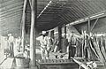
Great Cobar Copper Mining Syndicate's Refinery, Lithgow
-
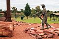
Miners Heritage Park, Cobar
-
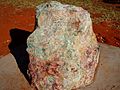
Rock with copper ore
-
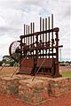
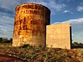
Battery
-
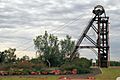
Elevator
-
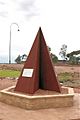
Monument to the miners who lost their lives
-
Cobar Sound Chapel
-
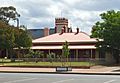
Cobar Police station in Barton St, with St Laurence O’Toole Catholic Church in the background
-
Cobar Police station
-
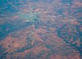
Aerial view 2009


See also
 In Spanish: Cobar para niños
