Mittagong facts for kids
Quick facts for kids MittagongNew South Wales |
|||||||||||||||
|---|---|---|---|---|---|---|---|---|---|---|---|---|---|---|---|
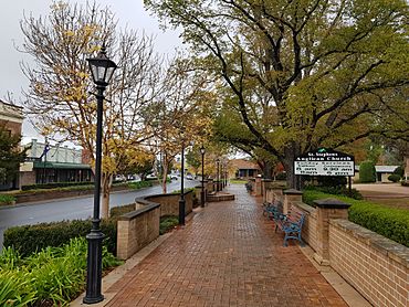
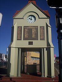
Mittagong town centre
|
|||||||||||||||
| Postcode(s) | 2575 | ||||||||||||||
| Elevation | 635 m (2,083 ft) | ||||||||||||||
| Location | |||||||||||||||
| LGA(s) | Wingecarribee | ||||||||||||||
| Region | Southern Highlands | ||||||||||||||
| County | Camden | ||||||||||||||
| Parish | Mittagong | ||||||||||||||
| State electorate(s) | Wollondilly | ||||||||||||||
| Federal Division(s) | Whitlam | ||||||||||||||
|
|||||||||||||||
|
|||||||||||||||
Mittagong (/mɪtəɡɒŋ/) is a town in the Southern Highlands of New South Wales, Australia. It's part of the Wingecarribee Shire. This town is often called the "gateway" to the Southern Highlands if you're traveling from Sydney. Mittagong sits high up, about 635 meters above sea level.
The town is close to other well-known places like Bowral, Berrima, and Moss Vale. It's also near smaller "Northern Villages" such as Yerrinbool and Colo Vale. Mittagong is also home to many growing wineries in the Southern Highlands region.
Contents
- What's in a Name? The Meaning of Mittagong
- A Look Back: Mittagong's History
- Exploring Mittagong's Geography
- Fun Things to Do: Mittagong Attractions
- Who Lives Here? Mittagong's Population
- Getting Around: Transport in Mittagong
- Important Places: Heritage Listings
- Places of Worship: Churches
- Learning Places: Schools
- Mittagong's Weather: Climate Information
What's in a Name? The Meaning of Mittagong
The name "Mittagong" is thought to come from an Aboriginal word. It might mean "little mountain." Other ideas for its meaning include "a companion" or "plenty of native dogs." This is because the Mittagong mountain range used to have many dingos.
A Look Back: Mittagong's History
The first European settler to live permanently in the Mittagong area was William Chalker. He arrived on May 10, 1821. William Chalker was a former convict from England. He became an important supervisor of government animals and a chief police officer in the Cowpastures area.
In 1988, a special plaque was put up to remember Chalker. This was part of Australia's 200th birthday celebrations. The plaque looks over an area once called Chalker's Flat, which is now known as Lower Mittagong. Many of his family members still live in the Mittagong and Bowral areas today.
Mittagong's Early Industries
Mittagong has a rich history of different industries. The first iron was melted here. The Mittagong Coal Mining Company and the Joadja Kerosene Shale company once operated in the area. Also, the first fresh milk and butter supply to Sydney came from Mittagong.
Steam trains were used to move iron ore and melted iron. Lake Alexandra, a small lake in town, was originally a water supply for the railway engines. These engines pulled coal from Mount Alexandra to the iron mines. The lake was drained in the 1890s. The land around it was then given to the local Council.
Ironstone was first found in the early 1830s when a new road was being built through Mittagong. About 15 years later, people started to mine the iron. In 1848, land was bought, and iron smelting began at the Fitzroy Iron Works. They used a small blast furnace. Newspapers at the time reported that the mine was successful. They showed examples of manufactured items in Sydney.
By 1849, a quarry was open, and stone was being prepared for new buildings. A brick-making area had also started. The mine was called the Fitz Roy iron mine. This was likely named after Sir Charles A. Fitz Roy, who was the Governor-General.
Modern Changes and Developments
Until the 1990s, many trucks passed through Mittagong. In winter, the town was also busy with skiers heading to the Australian Alps. Today, the Hume Highway goes around Mittagong. It also bypasses all the other towns in the Southern Highlands.
When the highway bypass first opened, some thought it might hurt Mittagong's businesses. This was because less traffic would pass through. However, by 1994, people realized it was actually good for the town. Mittagong became a popular rest stop for drivers and a great day trip destination from Sydney.
Mittagong is also home to Frensham School, a well-known private boarding school for girls. It was opened in 1913 by Winifred Mary West. Famous people like Dr Catherine Hamlin and former Lord Mayor of Sydney, Lucy Turnbull, went to this school.
The Mittagong Farm Homes for Boys, also known as Renwick, was located along Bong Bong Road. In 2013, the NSW Government apologized for the harsh treatment many children faced in this institution. The former residents are now working to have one of the homes turned into a museum. This museum would remind people of the injustices that happened there.
In March 2007, the Highlands Marketplace opened. This large shopping center is on the Old Hume Highway near Welby. It has big stores like Big W and Woolworths. The marketplace is built on the site of the original iron works from the 1800s. You can see some of the old remains and signs explaining the history in the car park. In November 2008, another shopping area called the Highlands Hub opened next to it. It has stores like OfficeWorks and Best & Less.
Exploring Mittagong's Geography
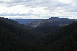
Mittagong is nestled between three smaller mountain reserves. These are Mount Alexandra (780 meters above sea level), Mount Gibraltar (888 meters above sea level), and Ninety Acre Hill (800 meters above sea level). Ninety Acre Hill is part of the larger Gibbergunyah Reserve.
A popular spot for both locals and visitors is Lake Alexandra. This is a small, man-made lake that flows into the nearby Nattai River. You can find lookouts at all three mountain reserves for amazing views. On Mount Gibraltar, you'll find Bowral Lookout, Mittagong Lookout, and Mount Jellore Lookout. Mount Alexandra has Katoomba Lookout and Box Vale Track Lookout. Gibbergunyah Reserve offers the Gib Lookout and Ninety Acre Hill Lookout.
You can also get a close view of Mount Gibraltar when you travel from Mittagong to Bowral along Bowral Road.
Fun Things to Do: Mittagong Attractions
Today, Mittagong offers visitors many things to see and do. You can explore its history, enjoy the beautiful scenery, find small waterfalls, and go on bushwalks. The town is also famous for its "Waratah" flowers, which bloom in November. An annual chamber music festival takes place here each Easter.
Tourists often visit Mount Gibraltar and Lake Alexandra. There are also several wineries located around and in Mittagong. The town also features one of Australia's first iron mining sites, which is close to Lake Alexandra. The main street has many shops, including antique stores.
Mittagong is especially known for being close to many of the Southern Highlands' wineries. These wineries have grown in the region since the 1980s. The soil and climate in Mittagong are thought to be perfect for viticulture, which is the growing of grapes for wine.
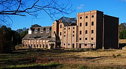
Mittagong is home to an old, abandoned building complex called "The Maltings." In the past, The Maltings were used as malthouses for a major New South Wales beer company, Tooth and Co.. You can see one of these old malthouse buildings when you enter Mittagong on the Old Hume Highway from Braemar. This building is one of the original ones and is over 100 years old. The complex is now empty and falling apart. There was an attempt to fix it up a few years ago, but it stopped.
Who Lives Here? Mittagong's Population
According to the 2021 census, the town of Mittagong had 6,090 people living there.
The wider Mittagong Statistical Area 2, which includes the town center and nearby villages like Welby and Braemar, had a population of 8,999 in 2016. About 2.5% of the people were Aboriginal and Torres Strait Islander. Most people (76.5%) were born in Australia. The next most common birthplaces were England (5.0%) and New Zealand (1.4%). Most people (86.7%) spoke only English at home.
Getting Around: Transport in Mittagong
Mittagong is located on the Old Hume Highway. This road used to connect Sydney, Canberra, and Melbourne. However, the highway was changed in 1992 to bypass the town. Some people thought this would harm businesses in Mittagong. Instead, the town has become a popular rest stop for drivers and a day trip spot for people from Sydney, which is only about an hour away.
You can still get to Mittagong from the Hume Highway. From the north, you can use the Aylmerton/Braemar exit. From the south, you can use the Welby exit.
The Mittagong railway station is on the Southern Highlands Line. Trains run regularly to and from Sydney and Moss Vale. Some trains also go to Goulburn. Long-distance trains to Canberra and Melbourne also stop at the station.
The town is also home to the Berrima Buslines depot. Berrima Buslines provides bus services throughout the entire Wingecarribee Shire. Several long-distance bus companies also serve Mittagong, with routes to Canberra, Melbourne, and Adelaide. Priors Scenic Express runs a service six days a week to Greater Sydney and to the South Coast of New South Wales.
Important Places: Heritage Listings
Mittagong has several sites that are listed for their historical importance:
- Main Southern railway: Mittagong railway station
- Old South Road: Hassall and Jefferis Cottages
- 5 Station Street: Old Mittagong Post Office
Places of Worship: Churches
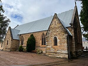
- St Stephen's Anglican Church – Cnr Main St & Station St
- St Michael's Catholic Church – Albert Street
- Highlands Baptist Church (Welby)
- Mittagong Church of Jesus Christ of Latter-Day Saints
- Highlands Christian Church – Regent Street
- Southern Highlands Foursquare Church (Pentecostalism)
- Mittagong Uniting Church
- Mittagong Presbyterian Church
Learning Places: Schools
- Frensham School
- Gib Gate Primary School
- Mittagong Public School
- St Michael's Catholic Primary School
- Tangara School (Special Education)
- Mittagong TSB (Renwick)
Mittagong's Weather: Climate Information
The climate data for Mittagong comes from nearby Bowral (Parry Drive), which recorded weather from 1961 to 2015. Summers are warm to mild, while winters are cool. Spring is usually dry.
| Climate data for Bowral (Parry Drive, 1961–2015); 690 m AMSL; 34.49° S, 150.40° E | |||||||||||||
|---|---|---|---|---|---|---|---|---|---|---|---|---|---|
| Month | Jan | Feb | Mar | Apr | May | Jun | Jul | Aug | Sep | Oct | Nov | Dec | Year |
| Record high °C (°F) | 40.0 (104.0) |
39.1 (102.4) |
35.7 (96.3) |
31.5 (88.7) |
25.5 (77.9) |
20.1 (68.2) |
20.3 (68.5) |
23.8 (74.8) |
29.1 (84.4) |
32.4 (90.3) |
38.3 (100.9) |
37.2 (99.0) |
40.0 (104.0) |
| Mean daily maximum °C (°F) | 25.5 (77.9) |
24.4 (75.9) |
22.4 (72.3) |
19.3 (66.7) |
15.4 (59.7) |
12.4 (54.3) |
11.6 (52.9) |
13.4 (56.1) |
16.3 (61.3) |
19.0 (66.2) |
21.4 (70.5) |
23.8 (74.8) |
18.7 (65.7) |
| Mean daily minimum °C (°F) | 13.4 (56.1) |
13.5 (56.3) |
11.6 (52.9) |
8.2 (46.8) |
5.3 (41.5) |
3.5 (38.3) |
2.1 (35.8) |
3.1 (37.6) |
5.3 (41.5) |
7.7 (45.9) |
9.8 (49.6) |
11.6 (52.9) |
7.9 (46.3) |
| Record low °C (°F) | 2.1 (35.8) |
1.8 (35.2) |
−0.7 (30.7) |
−2.2 (28.0) |
−6.3 (20.7) |
−8.2 (17.2) |
−11.2 (11.8) |
−6.1 (21.0) |
−5.7 (21.7) |
−2.6 (27.3) |
−2.2 (28.0) |
−1.4 (29.5) |
−11.2 (11.8) |
| Average precipitation mm (inches) | 81.9 (3.22) |
98.4 (3.87) |
95.2 (3.75) |
75.8 (2.98) |
69.6 (2.74) |
84.0 (3.31) |
45.3 (1.78) |
61.6 (2.43) |
55.8 (2.20) |
71.6 (2.82) |
92.4 (3.64) |
78.6 (3.09) |
931.7 (36.68) |
| Average precipitation days | 13.5 | 13.4 | 13.3 | 11.1 | 11.2 | 11.2 | 9.9 | 9.6 | 10.2 | 11.6 | 13.5 | 12.6 | 141.1 |
| Average afternoon relative humidity (%) | 57 | 64 | 61 | 61 | 65 | 67 | 64 | 56 | 54 | 56 | 60 | 56 | 60 |
More recent weather data can be found at the Moss Vale AWS (Airport) since 2001.
| Climate data for Moss Vale AWS (2001–2022); 678 m AMSL; 34.53° S, 150.42° E | |||||||||||||
|---|---|---|---|---|---|---|---|---|---|---|---|---|---|
| Month | Jan | Feb | Mar | Apr | May | Jun | Jul | Aug | Sep | Oct | Nov | Dec | Year |
| Record high °C (°F) | 40.9 (105.6) |
41.2 (106.2) |
34.0 (93.2) |
30.7 (87.3) |
23.4 (74.1) |
20.3 (68.5) |
21.4 (70.5) |
22.5 (72.5) |
30.4 (86.7) |
31.7 (89.1) |
37.9 (100.2) |
41.1 (106.0) |
41.2 (106.2) |
| Mean daily maximum °C (°F) | 26.2 (79.2) |
24.4 (75.9) |
21.8 (71.2) |
19.2 (66.6) |
15.5 (59.9) |
12.5 (54.5) |
11.9 (53.4) |
13.4 (56.1) |
16.7 (62.1) |
19.5 (67.1) |
22.0 (71.6) |
24.1 (75.4) |
18.9 (66.1) |
| Mean daily minimum °C (°F) | 14.2 (57.6) |
14.0 (57.2) |
12.1 (53.8) |
8.7 (47.7) |
4.9 (40.8) |
3.4 (38.1) |
2.5 (36.5) |
3.0 (37.4) |
5.4 (41.7) |
7.9 (46.2) |
10.5 (50.9) |
12.2 (54.0) |
8.2 (46.8) |
| Record low °C (°F) | 4.1 (39.4) |
5.7 (42.3) |
2.2 (36.0) |
−2.5 (27.5) |
−3.4 (25.9) |
−6.3 (20.7) |
−5.6 (21.9) |
−5.4 (22.3) |
−4.0 (24.8) |
−2.0 (28.4) |
−0.1 (31.8) |
2.0 (35.6) |
−6.3 (20.7) |
| Average precipitation mm (inches) | 65.0 (2.56) |
101.4 (3.99) |
96.6 (3.80) |
55.9 (2.20) |
48.3 (1.90) |
76.5 (3.01) |
63.7 (2.51) |
54.7 (2.15) |
41.9 (1.65) |
52.8 (2.08) |
72.3 (2.85) |
60.1 (2.37) |
784.5 (30.89) |
| Average precipitation days | 13.2 | 14.2 | 16.6 | 15.7 | 15.0 | 16.8 | 13.8 | 12.3 | 11.5 | 12.1 | 14.2 | 12.5 | 167.9 |
| Average afternoon relative humidity (%) | 51 | 60 | 59 | 58 | 60 | 63 | 61 | 53 | 51 | 51 | 56 | 52 | 56 |
 | Janet Taylor Pickett |
 | Synthia Saint James |
 | Howardena Pindell |
 | Faith Ringgold |


