
Nerriga, New South Wales facts for kids
Quick facts for kids NerrigaNew South Wales |
|||||||||||||||
|---|---|---|---|---|---|---|---|---|---|---|---|---|---|---|---|

Old butcher shop and house
|
|||||||||||||||

Nerriga
Location in New South Wales
|
|||||||||||||||
| Population | 72 (2016 census) | ||||||||||||||
| Postcode(s) | 2622 | ||||||||||||||
| Elevation | 630 m (2,067 ft) | ||||||||||||||
| Location | |||||||||||||||
| LGA(s) | Queanbeyan-Palerang Regional Council | ||||||||||||||
| Region | Southern Tablelands | ||||||||||||||
| County | St Vincent | ||||||||||||||
| Parish | Meangora | ||||||||||||||
| State electorate(s) | Monaro | ||||||||||||||
| Federal Division(s) | Eden-Monaro | ||||||||||||||
|
|||||||||||||||
Nerriga (/nɛrəɡə/) is a small village in the Southern Tablelands of New South Wales, Australia. It is part of the Queanbeyan-Palerang Regional Council. The village sits on the edge of Morton National Park, along the road connecting Braidwood and Nowra. In 2016, about 72 people lived in Nerriga and the areas around it.
Contents
Discovering Nerriga's Past
Nerriga has a long and interesting history. It started as a small settlement and grew, especially during the gold rush.
Early Settlers and Names
In 1828, a farmer named George Galbraith owned a large piece of land near the Endrick River. This property was called "Narriga." The name "Nerriga" was first written down by a surveyor, Robert Hoddle, in 1828. He was exploring the Shoalhaven River area. After Galbraith passed away in 1837, his land was bought by another settler, John Mackenzie.
Building The Wool Road
In 1840, a surveyor named James Larmer planned a village site for Nerriga. He also mapped out a path over the mountains to Vincentia. This path became known as The Wool Road. The idea was to create a way for farmers to move their wool and other goods from places like Braidwood and Goulburn to a port on Jervis Bay.
The Wool Road was finished in 1841. It was about 59 kilometers (37 miles) long and cost around £997 to build. In 1842, the road linking Nerriga to Braidwood was also greatly improved. Both of these important road projects used the labor of convicts. They worked under the direction of John Mackenzie, who owned land in Nerriga.
The Gold Rush Era
In 1851, gold was found in the Shoalhaven River. This discovery made the area around Nerriga much more popular. The town began to grow quickly. The Commercial Hotel, which is now called the Bark Tree Hotel, opened its doors around 1864.
Between 1878 and 1901, the Nerriga Mining Division was at its busiest. During this time, about 14,177 ounces (401,920 grams) of gold were found. Some gold was also found in quartz rocks, but not as much. People continued to search for gold in the area on a large scale until the 1960s.
Education in Nerriga
Nerriga had a state school for many years. It was open from 1868 to 1917 and again from 1928 to 1975. It was usually known as a "public school." Sometimes it was called a "provisional" or "half-time" school.
Modern Road Upgrades
In October 2010, the road between Nerriga and Nowra was greatly improved. This project was a joint effort by several government groups. The upgrade made it a high-quality, sealed road that could be used in all types of weather. This was a big help for the local community. A celebration was held to mark the completion of the road.
Facing Bushfires
In December 2019, the Currowan and Tianjara fires affected the areas around Nerriga. Many properties were damaged. The Nerriga Pub became a safe place for people who had to leave their homes. Thick smoke made it unsafe to stay in the community hall. Local residents worked hard to protect the pub from burning embers. Volunteers from the New South Wales Rural Fire Service later arrived to help.
Images for kids
-
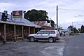
The Nerriga Hotel, a historic building in the village.
-
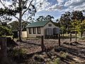
The old Nerriga Public School building.
-
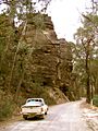
The road from Nerriga to Nowra before it was upgraded, showing the escarpment in Morton National Park.


