Carwoola facts for kids
Quick facts for kids CarwoolaNew South Wales |
|||||||||||||||
|---|---|---|---|---|---|---|---|---|---|---|---|---|---|---|---|

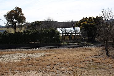
Burbong station house. The railway station was closed in 1975.
|
|||||||||||||||
| Postcode(s) | 2620 | ||||||||||||||
| Location |
|
||||||||||||||
| LGA(s) | Queanbeyan-Palerang Regional Council | ||||||||||||||
| County | Murray | ||||||||||||||
| Parish | Carwoola | ||||||||||||||
| State electorate(s) | Monaro | ||||||||||||||
| Federal Division(s) | Eden-Monaro | ||||||||||||||
|
|||||||||||||||
Carwoola is a small place in New South Wales, Australia. It's just south of the Kowen district in the Australian Capital Territory. The Molonglo River flows through Carwoola and then into the Molonglo Plains. Main roads like the Kings Highway and Captains Flat Road pass through it. Carwoola is part of the Queanbeyan-Palerang Regional Council and the Southern Tablelands area. Its boundaries are similar to the old Carwoola Parish.
Contents
What's in Carwoola?
Carwoola has a Community Hall where local events happen. It's looked after by the Community Association. There's also a Rural Fire Brigade, which is part of the NSW Rural Fire Service. This group helps fight bushfires and keep the area safe. You can also find two public areas in Bowen Street and Molonglo River Drive.
A group called Carwoola Landcare is also very active. They work to protect and improve the environment in the Molonglo River area.
Carwoola's Past
The first European explorers came to this area a long time ago. In October 1820, Charles Throsby, Joseph Wild, and James Vaughan explored nearby Kowan. They were guided by a local Aboriginal person named Taree. Later, in December 1820, Throsby's nephew, Charles Throsby Smith, with Wild, Vaughan, and another Aboriginal guide, reached where the Molonglo and Queanbeyan Rivers meet.
The very first European group to travel directly through Carwoola was led by Charles Throsby in March 1821. Joseph Wild and an Aboriginal guide were with him again.
Early Settlers
The first European settler to live on a large property in the area was Owen Bowen (1778-1840). He arrived in Australia in 1811. In 1824, he got permission to use a thousand acres of land at Marlow Plains. This area was an early name for the Limestone Plains. Bowen started a big dairy farm there. He bought the land in 1829 when more areas became open for settlement.
Another early settler was Timothy Beard. He arrived in Australia in 1805 and later received his freedom. In 1828, he started living on land near the Molonglo River. This area is now part of the Beard suburb.
A property next to Owen Bowen's was owned by William Balcombe. He was an important government official from 1823 until he passed away in 1829. Before coming to Australia, Balcombe worked on St Helena island. There, he became friends with Napoleon Bonaparte when Napoleon was in exile. Balcombe's friendship with Napoleon was seen as a problem, so he was moved to London before settling in Sydney.
In 1824, Governor Brisbane gave Balcombe a large piece of land. Balcombe called his property "The Briars." This name came from his estate on St Helena where Napoleon had stayed. William Balcombe Junior managed the Carwoola property. It was once thought that the Balcombe family brought two plants to Australia: the Sweet Briar rose and the Weeping Willow tree. However, this story was later found to be incorrect.
John Hosking (1806-1882) owned a large property called "Foxlow" station. He named it after his wife, Martha Foxlow Terry. Hosking settled there around 1835. The nearby town of Hoskinstown is named after him.
Thomas Rutledge bought land on the Molonglo Plain in the mid-1800s. He named it "Carwoola." This name came from the Aboriginal word "Carrowillah," which means "where the water meets the plain." This was the land first settled by Owen Bowen.
Carwoola had a school at different times between 1868 and 1924. Sometimes it was a "half-time" school, meaning it shared a teacher with another school. There was also a "half-time" school at Flannel Tree, in southwestern Carwoola, from 1910 to 1913 and again from 1919 to 1923.
Important Places
Carwoola has some places that are important for their history. These are called heritage-listed sites:
- 1071 Captains Flat Road: Carwoola Homestead
- Goulburn-Bombala railway: Burbong railway bridge
Bushrangers in the Area
The famous bushranger William Westwood, also known as Jacky Jacky, was active in the Carwoola area. In December 1840, he stopped someone at the 11-Mile turnoff. This happened after he escaped from his convict service at Gidleigh station, near Bungendore.
Burbong Railway Station
A railway station was built on the Bombala railway line in 1887. It was first called Molonglo. In 1890, its name was changed to Burbong, and a small community grew around it. The station closed in 1975.
2017 Bushfire
On February 17, 2017, a large bushfire started in Carwoola. It sadly destroyed 8 homes and burned about 3,500 hectares of land. Many other buildings were damaged or destroyed, along with vehicles and fences. Luckily, very few farm animals were lost. Two firefighters were injured while battling the blaze.
 | Lonnie Johnson |
 | Granville Woods |
 | Lewis Howard Latimer |
 | James West |


