
Narooma, New South Wales facts for kids
Quick facts for kids NaroomaNew South Wales |
|||||||||||||||
|---|---|---|---|---|---|---|---|---|---|---|---|---|---|---|---|

Bridge at Narooma on the Princes Highway
|
|||||||||||||||

Narooma
Location in New South Wales
|
|||||||||||||||
| Population | 3,342 (2016 census) | ||||||||||||||
| Established | 1881 | ||||||||||||||
| Postcode(s) | 2546 | ||||||||||||||
| Elevation | 30 m (98 ft) | ||||||||||||||
| Location | |||||||||||||||
| LGA(s) | Eurobodalla Shire | ||||||||||||||
| County | Dampier | ||||||||||||||
| State electorate(s) | Bega | ||||||||||||||
| Federal Division(s) | Eden-Monaro | ||||||||||||||
|
|||||||||||||||
Narooma is a town in New South Wales, Australia. It's located on the beautiful far south coast. The town is on the Princes Highway, which crosses the Wagonga Inlet to North Narooma. The historic village of Central Tilba is also close by to the south.
The name Narooma comes from a word in the local Aboriginal Australian language. It means "clear blue waters". In 2016, about 3,342 people lived in Narooma.
Contents
History of Narooma
Before Europeans settled here, the Yuin people lived along this coast. The Walbunga/Walbunja clan were the traditional owners of the Narooma area. Their language was likely a dialect of Dhurga.
There was an older settlement nearby called Punkalla. It was a port for other towns like Bodalla. You can still see old ruins of a jetty and timber mill there.
Gold Rush and Early Settlement
Gold was found near Central Tilba in 1880. A post office opened in 1881 at a place called "Noorooma". This was the original name for Narooma.
A new town was planned where Narooma is today in 1883. It was also called Noorooma until 1972. The town became a port in 1884.
Narooma's school opened in 1886, and its post office in 1889. At first, people traveled to Narooma by sea. From 1894, a hand-operated ferry crossed Wagonga Inlet. This ferry connected Narooma to North Narooma and then to Moruya. A mail coach also ran daily between Bega and Moruya.
Growing as a Tourist Spot
Narooma became a popular place for tourists in the early 1900s. The local oyster industry also started around this time. The Uniting Church on the Princes Highway was built in 1914. It's a great example of the Federation Carpenter Gothic style.
In 1929, a petrol-powered ferry was brought in to help cross the inlet. The Narooma bridge was a very important project. It was one of the first big bridges built on the Princes Highway. The bridge was built between 1929 and 1931. It crosses the Wagonga Inlet and is made of steel and concrete. It's one of only two bascule span bridges left in New South Wales. A walking path was added to the bridge in 1960.
A fish cannery opened in 1937 or 1940. It processed tuna and salmon. In 1972, the town's name was officially changed from Noorooma to Narooma.
Geology of Narooma

Narooma sits on something called the Narooma terrane. This land used to be thousands of kilometers away from Australia. Over a very long time, it moved west. It then joined onto the side of the Lachlan Fold Belt, which became part of Australia.
The rocks near Narooma are very old. They include Narooma Chert from the Cambrian period. You can also find turbidites, which are rocks formed from underwater landslides. There are even remains of an ancient submarine volcano with pillow lava.
Sports in Narooma
The most popular sport in Narooma is rugby league. The town has a team called the Narooma Devils. They play in the local Group 16 Rugby League competition. The club started in 1929. They play their games at Bill Smyth Memorial Oval in the center of town.
Attractions and Landmarks


Narooma has many interesting places to visit.
Montague Island
Montague Island is a special nature reserve. It's about eight kilometers offshore from Narooma. You can take a boat tour from Narooma to visit the island.
Gulaga Mountain
Gulaga mountain was once known as Mt. Dromedary. Captain Cook named it because it looked like a camel's hump. You can reach Gulaga from the village of Tilba Tilba. The mountain has eight types of rainforests. It also has important rock sites for the local Aboriginal people.
Beaches and Australia Rock
The area around Narooma has beautiful beaches. These include Dalmeny Beach, Narooma Beach, Bar Beach (which has calm water), and Yabarra Beach.
Australia Rock is a famous landmark. It's found where the inlet meets the sea. This rock has a hole that looks like the map of Australia! Some people think it formed naturally from thousands of years of erosion. Others tell a story that a ship's chains accidentally created the hole.
Narooma Golf Course
The Narooma Golf Course opened in 1930. It's known as one of Australia's best public golf courses. It's a challenging course with amazing views. You can see Montague Island to the east and Glass House Rocks to the south.
Great Southern Blues Festival
The Great Southern Blues Festival used to be held in Narooma every October. It moved to Batemans Bay in 2010. But it returned to Narooma in 2013 and continued until 2015.
Climate of Narooma
Narooma has an oceanic climate (Cfb). This means it has mild temperatures all year round. It's quite sunny, with over 100 clear days each year. The winters are drier and sunnier because Narooma is on the sheltered side of the dividing range. Narooma is the southernmost place in Australia with a subtropical climate. This is because of the subtropical plants found on nearby Mount Dromedary and Gulaga National Park.
Narooma gets less rain than other coastal cities in New South Wales, like Sydney. This is partly because of its location. It is sometimes protected from big storms coming from the east.
| Climate data for Narooma (Marine Rescue) 1991–2020 averages, 1910–present extremes | |||||||||||||
|---|---|---|---|---|---|---|---|---|---|---|---|---|---|
| Month | Jan | Feb | Mar | Apr | May | Jun | Jul | Aug | Sep | Oct | Nov | Dec | Year |
| Record high °C (°F) | 43.8 (110.8) |
39.8 (103.6) |
38.9 (102.0) |
34.0 (93.2) |
27.3 (81.1) |
23.2 (73.8) |
25.3 (77.5) |
27.5 (81.5) |
33.9 (93.0) |
36.2 (97.2) |
38.4 (101.1) |
39.5 (103.1) |
43.8 (110.8) |
| Mean daily maximum °C (°F) | 23.9 (75.0) |
23.6 (74.5) |
22.8 (73.0) |
21.2 (70.2) |
19.2 (66.6) |
17.1 (62.8) |
16.6 (61.9) |
17.2 (63.0) |
18.7 (65.7) |
19.7 (67.5) |
20.9 (69.6) |
22.1 (71.8) |
20.2 (68.4) |
| Mean daily minimum °C (°F) | 17.1 (62.8) |
17.2 (63.0) |
15.7 (60.3) |
13.4 (56.1) |
10.5 (50.9) |
8.4 (47.1) |
7.1 (44.8) |
7.6 (45.7) |
9.4 (48.9) |
11.5 (52.7) |
13.7 (56.7) |
15.5 (59.9) |
12.3 (54.1) |
| Record low °C (°F) | 9.4 (48.9) |
10.0 (50.0) |
7.0 (44.6) |
6.1 (43.0) |
0.0 (32.0) |
1.1 (34.0) |
0.6 (33.1) |
0.5 (32.9) |
0.8 (33.4) |
2.0 (35.6) |
5.0 (41.0) |
7.5 (45.5) |
0.0 (32.0) |
| Average precipitation mm (inches) | 84.0 (3.31) |
105.5 (4.15) |
102.6 (4.04) |
77.3 (3.04) |
67.1 (2.64) |
82.5 (3.25) |
55.6 (2.19) |
55.9 (2.20) |
61.5 (2.42) |
75.2 (2.96) |
82.5 (3.25) |
79.7 (3.14) |
927.4 (36.51) |
| Average precipitation days | 12.2 | 11.3 | 11.7 | 9.1 | 7.5 | 9.2 | 7.2 | 7.3 | 9.6 | 11.6 | 12.8 | 11.7 | 121.2 |
| Average afternoon relative humidity (%) | 73 | 74 | 69 | 67 | 63 | 61 | 59 | 57 | 63 | 68 | 72 | 72 | 67 |
| Average dew point °C (°F) | 16.6 (61.9) |
17.0 (62.6) |
15.1 (59.2) |
13.0 (55.4) |
9.9 (49.8) |
7.8 (46.0) |
6.6 (43.9) |
6.5 (43.7) |
8.8 (47.8) |
11.1 (52.0) |
13.1 (55.6) |
14.6 (58.3) |
11.7 (53.1) |
| Source 1: Bureau of Meteorology, Marine Rescue (1991–2020) | |||||||||||||
| Source 2: Bureau of Meteorology, Marine Rescue (all years) | |||||||||||||
Images for kids
-
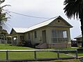
Narooma court house
-
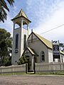
The Uniting Church built 1914
-
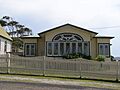
The parsonage associated with Narooma's Uniting Church


See also
 In Spanish: Narooma para niños
