Moruya, New South Wales facts for kids
Quick facts for kids MoruyaNew South Wales |
|||||||||||||||
|---|---|---|---|---|---|---|---|---|---|---|---|---|---|---|---|

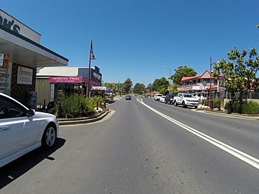
Moruya main street
|
|||||||||||||||
| Established | 1851 | ||||||||||||||
| Postcode(s) | 2537 | ||||||||||||||
| Elevation | 3 m (10 ft) | ||||||||||||||
| Location |
|
||||||||||||||
| LGA(s) | Eurobodalla Shire | ||||||||||||||
| County | Dampier | ||||||||||||||
| Parish | Moruya | ||||||||||||||
| State electorate(s) | Bega | ||||||||||||||
| Federal Division(s) | Gilmore | ||||||||||||||
|
|||||||||||||||
Moruya is a town on the far south coast of New South Wales, Australia. It is located right on the Moruya River. The Princes Highway goes through the town.
Moruya is about 305 kilometres (190 miles) south of Sydney. It is also about 175 kilometres (109 miles) from Canberra. In 2021, Moruya had a population of 4,295 people. The town mainly relies on farming, growing seafood, and tourism. The local government, the Eurobodalla Shire Council, has its main offices in Moruya.
Contents
History of Moruya
The South Coast area of New South Wales is the traditional home of the Yuin people. The land in and around Moruya belongs to the Bugelli-Manji clan of the Yuin nation.
The name "Moruya" comes from an Aboriginal word. It is thought to mean "home of the black swan". Black swans are often seen in the local lakes and rivers. The black swan is a special symbol for the area.
Early European Settlement
European settlers started arriving in the 1820s. This happened after the "limits of location" were expanded in 1829. These limits decided where people could officially settle. Before that, in 1828, a surveyor named Thomas Florance mapped the coast from Batemans Bay to Moruya.
The first European settler was Francis Flanagan, from Ireland. He was given land on the north side of the river in 1829. In 1830, John Hawdon set up a farm nearby. He later got official land on the north bank of the river in 1831. He named his property Kiora. A small village soon grew around Kiora.
In 1835, William Morris started a farm called Gundary across the river. William Campbell later bought this farm in 1845. The centre of Moruya town was mapped out in 1850. The town was officially named in 1851. It grew around a track that led to the river, where a ferry (punt) crossed. This track was named Vulcan Street because a blacksmith worked there. Other streets were named after important people or features.
Town Growth and Industries
Moruya officially became a municipality (a self-governing town) in 1891. The main jobs and industries at that time were cutting timber, mining for gold, dairy farming, and quarrying for granite. The first bridge over the Moruya River was built in 1876. However, floods often damaged it. New bridges were built in 1900, 1945, and the most recent one in 1966.
Moruya During World War II
During World War II, the Moruya airport was used by the RAAF. It was a base for planes during the war. On August 3, 1942, a fishing boat called Dureenbee was attacked. A Japanese submarine attacked it off the coast near Moruya. Three sailors died and are buried in the Moruya cemetery. A special "bush memorial" remembers these sailors and eight airmen. These airmen also died while working from the Moruya airport during the war. The memorial is at the old wartime airstrip.
On December 25, 1944, a US cargo ship, the USS Robert J. Walker, was hit by a torpedo. A German submarine, the U-862, attacked it near Moruya. The ship sank the next day. Two people died, but 67 people survived.
More recently, rural areas around Moruya were affected by the big 2019–20 Australian bushfire season.
Heritage-Listed Places
Moruya has some important historical sites. These places are protected because of their special heritage. They include:
- Moruya and District Historical Society, 85 Campbell Street: This is where you can find the Abernethy and Co Stonemason's Lathe.
- 13 Page Street: This is the Moruya Mechanics' Institute.
Moruya Granite
Moruya is famous for its granite stone. This granite was used to build very important Australian landmarks. A great example is the Sydney Harbour Bridge. The stone for the bridge's huge towers came from quarries in Moruya. It was easy to move the granite to Sydney because the quarries were close to the water.
Quarrying for granite started in the late 1850s. Two brothers, Joseph and John Flett Louttit, began the work. Their quarry was on the south side of the river. It produced stone for many famous Sydney buildings. These include the columns of the General Post Office in Martin Place. It also provided stone for the base of the Captain Cook statue in Hyde Park.
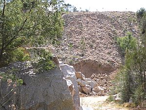
The Moruya Quarry, also known as the Government Quarry, opened in 1876. It is on the northern bank of the Moruya River. From 1925 to 1932, about 250 stonemasons worked there. They were moved to Moruya by the company building the Harbour Bridge. They produced a huge amount of stone for the bridge's towers. This included 173,000 blocks of stone. They also made 200,000 yards of crushed stone for concrete. Moruya granite was also used for the Sydney Cenotaph in Martin Place.
During these seven years, a small town grew near the quarry. It had about 70 houses and was called Granitetown. Not much of that town remains today. The quarry also had a tramway to move the stone, which closed in 1931. The wharf used by the quarry was replaced by a fishing platform around 2008.
Today, the New South Wales Department of Infrastructure, Planning, and Natural Resources operates the Moruya Quarry. Another quarry, west of the main one, was run by the Ziegler family.
Shopping and Services
Moruya has many shops, banks, and services along its main street. Supermarkets are located on nearby streets. There is a Harris Scarfe store in town. Moruya has two main supermarkets: a Woolworths (opened in 2000) and an IGA (opened in 2013).
Moruya is also home to Southern Phone, a regional phone company. The town is known for its popular markets. You can find fresh fruit and vegetables at the markets on Tuesday afternoons and Saturdays. These markets are popular with both locals and visitors.
Landmarks
Moruya Airport (code MYA) is on the north side of Moruya Heads. The airport runway is right next to the beach. Flights into Moruya offer beautiful views of the coastline as they land. Rex Airlines flies mostly Saab 340B planes from Moruya. These flights go to Sydney and Merimbula. You can also get connecting flights to Melbourne from there.
Climate
Moruya has a mild oceanic climate. This means it has warm, wet summers and cool, somewhat drier winters. The winters are drier because of the foehn effect. This happens when the Great Dividing Range mountains block rain from westerly cold fronts. The town enjoys about 121 clear days each year.
| Climate data for Moruya Heads Pilot Station (1991–2020 averages, 1910–2024 extremes) | |||||||||||||
|---|---|---|---|---|---|---|---|---|---|---|---|---|---|
| Month | Jan | Feb | Mar | Apr | May | Jun | Jul | Aug | Sep | Oct | Nov | Dec | Year |
| Record high °C (°F) | 43.9 (111.0) |
43.3 (109.9) |
40.6 (105.1) |
35.1 (95.2) |
28.6 (83.5) |
24.4 (75.9) |
25.6 (78.1) |
30.0 (86.0) |
35.4 (95.7) |
37.2 (99.0) |
41.6 (106.9) |
42.2 (108.0) |
43.9 (111.0) |
| Mean daily maximum °C (°F) | 24.0 (75.2) |
24.0 (75.2) |
23.2 (73.8) |
21.5 (70.7) |
19.4 (66.9) |
17.1 (62.8) |
16.7 (62.1) |
17.6 (63.7) |
19.3 (66.7) |
20.5 (68.9) |
21.3 (70.3) |
22.6 (72.7) |
20.6 (69.1) |
| Mean daily minimum °C (°F) | 17.1 (62.8) |
17.1 (62.8) |
15.6 (60.1) |
12.8 (55.0) |
10.0 (50.0) |
8.0 (46.4) |
6.6 (43.9) |
7.2 (45.0) |
9.3 (48.7) |
11.4 (52.5) |
13.5 (56.3) |
15.4 (59.7) |
12.0 (53.6) |
| Record low °C (°F) | 7.8 (46.0) |
7.4 (45.3) |
5.9 (42.6) |
3.2 (37.8) |
2.2 (36.0) |
0.4 (32.7) |
−0.3 (31.5) |
0.1 (32.2) |
0.6 (33.1) |
3.2 (37.8) |
4.7 (40.5) |
5.6 (42.1) |
−0.3 (31.5) |
| Average rainfall mm (inches) | 86.8 (3.42) |
102.8 (4.05) |
88.5 (3.48) |
66.4 (2.61) |
54.9 (2.16) |
95.4 (3.76) |
56.8 (2.24) |
57.0 (2.24) |
50.9 (2.00) |
77.6 (3.06) |
82.6 (3.25) |
87.5 (3.44) |
907.2 (35.72) |
| Average rainy days (≥ 0.2 mm) | 12.1 | 11.3 | 10.9 | 8.3 | 6.9 | 7.8 | 6.4 | 5.8 | 8.8 | 10.5 | 11.3 | 11.7 | 111.8 |
| Average relative humidity (%) | 72 | 73 | 69 | 65 | 63 | 60 | 58 | 56 | 61 | 65 | 69 | 71 | 65 |
| Average dew point °C (°F) | 16.8 (62.2) |
17.4 (63.3) |
16.0 (60.8) |
13.0 (55.4) |
10.5 (50.9) |
8.0 (46.4) |
6.7 (44.1) |
6.8 (44.2) |
9.0 (48.2) |
11.0 (51.8) |
13.1 (55.6) |
15.1 (59.2) |
12.0 (53.6) |
| Source 1: Bureau of Meteorology, Moruya Heads Pilot Station (1991–2020) | |||||||||||||
| Source 2: Bureau of Meteorology, Moruya Heads Pilot Station (all years) | |||||||||||||
Famous People from Moruya
Many interesting people have lived in Moruya, including:
- Sarah Andrews – a former cricket player who played for Australia.
- Josh Cunningham – a musician from the band The Waifs.
- Charles Harpur – a poet who was also a farmer in the Eurobodalla area.
- Jarrad Kennedy – a former rugby league football player.
- Norm Ryan – a politician who represented the Labor party.
- Michael Weyman – a former rugby league football player who played for the Kangaroos.
- Richie Williams – a former rugby league player.
- Teig Wilton – a rugby league player.
- Bill Woods – a television sports presenter.
- Stevie Wright – the lead singer of the band The Easybeats.
- Jane Duren – an Aboriginal activist in the South Coast area during the 1920s.
 | William L. Dawson |
 | W. E. B. Du Bois |
 | Harry Belafonte |


