
Great Ocean Road facts for kids
Quick facts for kids Great Ocean RoadVictoria |
|
|---|---|
 |
|
| Great Ocean Road memorial arch at Eastern View | |
 |
|
| General information | |
| Type | Highway |
| Length | 240 km (149 mi) |
| Opened | 26 November 1932 |
| Route number(s) | |
| Former route number |
|
| Tourist routes | (Eastern View–Torquay) |
| Major junctions | |
| East end | Torquay, Victoria |
|
|
| West end | Allansford, Victoria |
| Location(s) | |
| Major settlements | Anglesea, Aireys Inlet, Lorne, Wye River, Kennett River, Apollo Bay, Lavers Hill, Port Campbell, Peterborough |
| Highway system | |
| Highways in Australia National Highway • Freeways in Australia Highways in Victoria |
|
The Great Ocean Road is a famous road in Australia. It stretches for about 240 kilometers (150 miles) along the beautiful southeastern coast of Victoria. This special road connects the towns of Torquay and Allansford.
What makes this road truly unique is its history. It was built by soldiers who returned from World War I between 1919 and 1932. The road was made to honor the soldiers who died in the war, making it the world's largest war memorial.
The Great Ocean Road winds through amazing landscapes. You'll see stunning coastlines, thick rainforests, and towering cliffs. It also leads to famous landmarks like the Twelve Apostles, which are huge limestone rock formations in the ocean. Because of its beauty and history, the road is a very popular place for tourists to visit.
The city of Geelong, near Torquay, benefits a lot from visitors to the road. In 2008, a survey by the Royal Automobile Club of Victoria (RACV) named it the top tourism experience in the state. People loved recommending it to others!

Contents
Exploring the Great Ocean Road
The Great Ocean Road starts in Torquay and goes west, ending near Warrnambool at Allansford. The road has two lanes, one for each direction of traffic. The speed limit changes along the way, from 50 km/h in towns to 100 km/h in open areas.
This road is a major attraction because much of it follows the coastline. East of the Otway Ranges, it's known as the Surf Coast. West of Cape Otway, it's called the Shipwreck Coast. Along the drive, you get amazing views of Bass Strait and the Southern Ocean.

The road passes through lush rainforests, sandy beaches, and cliffs made of limestone and sandstone. These cliffs can wear away over time due to weather. You'll travel through towns like Anglesea, Lorne, Apollo Bay, and Port Campbell. Port Campbell is famous for its natural rock formations, including Loch Ard Gorge, The Grotto, London Bridge, and the Twelve Apostles. Some parts of the road near Torquay are very close to the ocean, with steep cliffs. Signs warn drivers about possible rockfalls.


How the Road Was Built
The idea for the Great Ocean Road came about at the end of World War I. A man named William Calder suggested that soldiers returning from the war could build roads in less populated areas. At that time, the rugged coast of Victoria was hard to reach. People thought the new road would connect small towns, help the timber industry, and boost tourism.
Planning for the road, first called the South Coast Road, began in 1918. The idea was for it to start at Barwon Heads, follow the coast around Cape Otway, and finish near Warrnambool. In 1918, a private company called the Great Ocean Road Trust was formed. Its president was Howard Hitchcock. The company raised a lot of money from people and loans. The plan was to charge drivers a small fee (a toll) to use the road until the money was paid back. After that, the road would belong to the state.
Building the Road
Construction of the Great Ocean Road started on September 19, 1919. About 3,000 returned soldiers worked on the project. This was a way to remember the soldiers who died in World War I. The survey team, who mapped out the path, moved slowly through thick bush, about three kilometers (1.8 miles) a month.
Most of the work was done by hand. Workers used explosives, picks, shovels, and wheelbarrows. Some small machines were also used. The hardest parts to build were along the steep coastal cliffs. Workers were paid 10 shillings and sixpence for an eight-hour day and also worked half-days on Saturdays. They lived in tents and ate meals together in a large dining tent. Even though the camps were isolated, the workers had things like a piano, a record player, games, and newspapers to keep them entertained.

Opening and Early Days
The first part of the road, from Eastern View to Lorne, officially opened on March 18, 1922. There were big celebrations! However, it closed again for more work and reopened on December 21, 1922. This is when tolls began to help pay for the building costs. Cars paid two shillings, and wagons with more than two horses paid 10 shillings at the Eastern View toll gate.
In November 1932, the section from Lorne to Apollo Bay was finished. This meant the entire road was complete! Victoria's Lieutenant-Governor, Sir William Irvine, officially opened it in a ceremony near the Grand Pacific Hotel in Lorne. The road was then recognized as the world's largest war memorial.
Howard Hitchcock, who was key to getting the road built, sadly died before it was finished. But his car was driven in the opening procession to honor him. A memorial for him was built at Mount Defiance, near Lorne. He is often called the "Father of the Road."


When it first opened, the road was quite challenging to drive. It was narrow, often only wide enough for one car at a time. Areas with steep cliffs were especially tricky. Drivers had few places to pull over to let other cars pass. On October 2, 1936, the road was given to the State Government, and the tolls were removed.
In 1939, a memorial arch was built at Eastern View to honor W.T.B. McCormick, who was also important to the road's creation. The arch was made of timber logs on a stone base. It has been rebuilt twice since then, after being destroyed by bushfires in 1983.
In 1962, the road was called "one of the world's great scenic roads." Even with improvements, it was still a tough drive. The Victorian Police even used it for training their drivers!
Over the years, the Great Ocean Road has faced challenges from nature. Storms, landslides, and bushfires have sometimes closed parts of the road. In 2011, a section collapsed due to heavy rain. Also in 2011, the road was added to the Australian National Heritage List, recognizing its special importance.
Fun Events Along the Road
Great Ocean Road Marathon
A 45-kilometer (28-mile) part of the Great Ocean Road, between Lorne and Apollo Bay, is used for the yearly "Great Ocean Road Marathon." This race started in 2005 and is part of the Great Ocean Road Running Festival. Runners from all over the world come to compete.
Cycling Events
The Great Ocean Road is also a popular spot for cycling races. In 2015, famous cyclist Cadel Evans announced that the road would host the Cadel Evans Great Ocean Road Race. This event includes races for professional men and women, as well as a "People's Ride" where anyone can join in.
Another cycling event, Wiggle Amy's Gran Fondo, happens in September. It uses the section between Lorne and Skenes Creek. This is one of the few cycling events in Australia where the road is completely closed to other traffic. It's named after Amy Gillett, a cyclist who sadly died in an accident in Germany in 2005.
See also
- Great Ocean Walk
- Howard Hitchcock
- Loch Ard Gorge
- London Bridge (Victoria)
- The Grotto
- The Twelve Apostles
- Cadel Evans Great Ocean Road Race
Images for kids
-
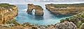
The former Island Archway off the Loch Ard Gorge, which collapsed in 2009.
