
Wollongong facts for kids
Quick facts for kids WollongongNew South Wales |
|||||||||||||||
|---|---|---|---|---|---|---|---|---|---|---|---|---|---|---|---|
|
|
|||||||||||||||

Wollongong
Location in New South Wales
|
|||||||||||||||
| Postcode(s) | 2500 | ||||||||||||||
| Elevation | 5 m (16 ft) | ||||||||||||||
| Area | 572.2 km2 (220.9 sq mi) | ||||||||||||||
| Time zone | AEST (UTC+10) | ||||||||||||||
| • Summer (DST) | AEDT (UTC+11) | ||||||||||||||
| Location | |||||||||||||||
| LGA(s) |
|
||||||||||||||
| Region | Illawarra | ||||||||||||||
| State electorate(s) |
|
||||||||||||||
| Federal Division(s) | Cunningham | ||||||||||||||
|
|||||||||||||||
|
|||||||||||||||
.jpg)

.jpg)
_(cropped).jpg)
.jpg)
.jpg)
Wollongong (pronounced WUUL-ən-gong) is a city in the Illawarra region of New South Wales, Australia. The name likely comes from the Dharawal language. It might mean 'five islands/clouds', 'ground near water', or 'sound of the sea'.
Wollongong is on a narrow strip of land. This land sits between the Illawarra Escarpment (a steep cliff) and the Pacific Ocean. It is about 85 kilometers (53 miles) south of central Sydney. In June 2018, Wollongong had about 302,739 people. This makes it the third-largest city in New South Wales. Only Sydney and Newcastle are bigger. It is the tenth-largest city in Australia. Tania Brown is the current Lord Mayor, elected in 2024.
The Wollongong area stretches from Helensburgh in the north to Windang and Yallah in the south. The city is known for its heavy industry, busy port, and beautiful natural setting. It has many surf beaches and the rainforest-covered Illawarra escarpment. Wollongong has a long history of coal mining and factories. Many tourists visit each year. It is also a main center for the South Coast fishing industry. The University of Wollongong has about 38,000 students.
Contents
History of Wollongong


The Dharawal Indigenous Australians first lived in this area. The first Europeans to visit were George Bass and Matthew Flinders in 1796. They landed at Lake Illawarra. Early European settlers were cedar cutters in the 1800s. Then came farmers in 1812. Charles Throsby built a stockman's hut here in 1815. The first land grants were given in 1816.
In 1830, a military barracks was built near the harbor. More settlers arrived, and a town was planned in 1834. On November 26, 1834, the town was officially named. George Brown built the first court house. Convicts built the main road down the Escarpment through Bulli Pass in 1835–36. By 1856, Wollongong had 864 people.
In 1858, a new court house was built. A horse-drawn tramway from Mount Keira to the harbor was finished in 1861. A telegraph line opened in 1862. In 1865, Wollongong got its first gas supply. In 1868, the harbor was made bigger and named Belmore Basin.
.jpg)
In 1871, the old lighthouse was completed. In 1881, a British clipper ship, the Queen of Nations, crashed near Towradgi Creek. Its cargo included 24,000 bottles of Hennessy Cognac. Police and customs officers saved many bottles. But some were taken by people nearby. The ship's wreck is still there, close to the shore. Sometimes, storms uncover parts of it.


In 1880, steam trains started carrying coal from Mount Keira mine to the harbor. Gas street lights came in 1883. A new court house was built in Market Street in 1885. It was designed in a grand style. The first town hall was built in 1886. The Illawarra Railway reached Wollongong in 1887. It now goes south to Bomaderry.
Coal has been mined in the area since 1797. Australia's worst coal mining disaster happened in 1902. An explosion at the Mount Kembla mine killed 94 men and boys. The youngest was 14. Two more men died trying to help. In 1916, Wollongong High School opened.
_(27197371454).jpg)
Factories came to the region because coal was easy to find. In 1928, Hoskins (later Australian Iron & Steel) started a steelworks at Port Kembla. This is a few kilometers south of Wollongong. The steelworks became a world-class producer of flat steel. It makes about 5 million tonnes each year. Other industries also set up in Port Kembla. These include a fertilizer plant, a copper smelter, and a coal export terminal.

In 1936, the new Wollongong Lighthouse was finished. In 1942, Wollongong was officially named a City. The City of Greater Wollongong was formed in 1947. By 1954, Wollongong had 90,852 people. In 1961, the Wollongong University College was started. In 1965, the Westfield shopping center opened in Figtree.
In 1985, the railway line to Wollongong was electrified. In 1993, it was extended to Dapto. The Wollongong Mall was finished in 1986. It was first a pedestrian area, then open to traffic, and now it is a pedestrian area again.
In 1987, new council buildings and a library were completed. The Crown Gateway Shopping Centre was also finished. In 1988, the Illawarra Performing Arts Centre (IPAC) opened. Prince Charles and Princess Diana officially opened it. In 1998, the 6000-seat WIN Entertainment Centre opened.
In 1999, the Gateway and Crown Central malls joined to become Wollongong Central. In 2000, the Olympic torch passed through Wollongong for the Sydney Olympics. By 2001, Wollongong had 181,612 people. In 2005, Qantas started daily flights from Wollongong to Melbourne. These flights stopped in 2008.
In 2006-2007, the library was updated. The beachfront was also renovated with a new lookout. In June 2007, storms caused bad beach erosion. This was the worst in 30 years.
Even though some older industries have slowed down, Wollongong's economy is growing. It now includes higher education, arts, tourism, and construction. However, heavy industry is still very important to the city.
In 2024, the wreck of the coal ship SS Nemesis was found off Wollongong. It sank almost 120 years ago while sailing to Melbourne.
Historic Places in Wollongong

Wollongong has many places listed for their history. These include:
- Church Street: St Michael's Cathedral
- Cliff Road: North Beach Precinct
- Cliff Road and Endeavour Drive: Wollongong Harbour Precinct
- 87 Crown Street: 87 Crown Street
- 91 Crown Street: Old Wollongong East Post Office
- Darling Street: Elouera House
- Illawarra railway: Wollongong railway station
- 197 Keira Street: Regent Theatre
- 11 Market Street: Old Wollongong Telegraph and Post Office
- 31–33 Smith Street: Little Milton
Wollongong's Geography

Wollongong has a unique geography. It is on a narrow coastal plain. The Tasman Sea is to the east. A steep cliff, the Illawarra Escarpment, is to the west. The plain is wider in the south and narrower in the north. The city center is in the middle. South of the city is Lake Illawarra, a large lagoon.
The escarpment is 150 to 750 meters (490 to 2,460 feet) high. Famous mountains here include Mount Keira (464 m), Mount Kembla (534 m), and Mount Murray (768 m). Coal mines have entrances along the escarpment. Most of the escarpment is natural, with forests. It is protected and forms a beautiful background for the city.

In the north, the escarpment meets the coast. The Lawrence Hargrave Drive road follows the cliff. Because of rockfalls, part of this road was replaced in 2005 by the Sea Cliff Bridge. This bridge goes just off the coast. The Illawarra railway line goes through tunnels to reach Sydney. The Southern Freeway and Princes Highway are other routes. They go down the escarpment at Bulli Pass or Mount Ousley.
To the south, the plain is widest around Albion Park. Here, it has Lake Illawarra, a large saltwater lagoon. A sandy strip separates it from the Pacific Ocean.

The coastal strip has very fertile soil. This made it good for farming in the 1800s. It has many hills. Several short, fast-flowing creeks cross the strip. These include Fairy Creek and Mullet Creek.
The coastline has many beaches with fine, pale gold sand. Rocky headlands sometimes break up the beaches. Some headlands have been changed to create harbors. These are at Wollongong, Port Kembla, Shellharbour, and Kiama. South of Wollongong, near Port Kembla, are The Five Islands. These islands are a safe place for wildlife.

Wollongong's Climate
Wollongong has an oceanic climate. The highest temperature recorded was 44.1 °C (111.4 °F) on January 1, 2006. The lowest was 0.8 °C (33.4 °F) on July 27, 1986. Wollongong gets about 107 clear days each year.
Rainfall happens throughout the year, but more in the first half. It often rains because of the escarpment and being close to the Tasman Sea. This makes it get more moist easterly winds. On August 18, 1998, Wollongong had a big flood. It rained 316 mm (12.4 inches) in mostly 3 hours. Wollongong also has thunderstorms in warmer months. These bring lightning, heavy rain, and sometimes hail.
July and August are windy months. Westerly gales can blow over 100 km/h (62 mph). These are usually dry winds from the Great Dividing Range.
| Climate data for Wollongong University (1970–2008) | |||||||||||||
|---|---|---|---|---|---|---|---|---|---|---|---|---|---|
| Month | Jan | Feb | Mar | Apr | May | Jun | Jul | Aug | Sep | Oct | Nov | Dec | Year |
| Record high °C (°F) | 44.1 (111.4) |
41.7 (107.1) |
40.2 (104.4) |
35.4 (95.7) |
28.5 (83.3) |
24.7 (76.5) |
25.7 (78.3) |
30.3 (86.5) |
34.2 (93.6) |
38.8 (101.8) |
40.6 (105.1) |
41.5 (106.7) |
44.1 (111.4) |
| Mean daily maximum °C (°F) | 25.8 (78.4) |
25.8 (78.4) |
24.5 (76.1) |
22.6 (72.7) |
20.1 (68.2) |
17.9 (64.2) |
17.2 (63.0) |
18.6 (65.5) |
20.7 (69.3) |
22.5 (72.5) |
23.1 (73.6) |
24.9 (76.8) |
22.0 (71.6) |
| Mean daily minimum °C (°F) | 17.9 (64.2) |
18.1 (64.6) |
16.6 (61.9) |
13.8 (56.8) |
11.6 (52.9) |
9.6 (49.3) |
8.4 (47.1) |
8.6 (47.5) |
10.5 (50.9) |
12.5 (54.5) |
14.2 (57.6) |
16.3 (61.3) |
13.2 (55.8) |
| Record low °C (°F) | 9.6 (49.3) |
10.3 (50.5) |
9.1 (48.4) |
5.1 (41.2) |
3.1 (37.6) |
2.0 (35.6) |
0.8 (33.4) |
2.0 (35.6) |
3.3 (37.9) |
4.7 (40.5) |
5.4 (41.7) |
8.3 (46.9) |
0.8 (33.4) |
| Average rainfall mm (inches) | 130.3 (5.13) |
156.4 (6.16) |
160.4 (6.31) |
129.3 (5.09) |
106.4 (4.19) |
112.4 (4.43) |
63.4 (2.50) |
83.3 (3.28) |
67.4 (2.65) |
100.5 (3.96) |
115.6 (4.55) |
94.6 (3.72) |
1,320.9 (52.00) |
| Average rainy days | 13.8 | 13.7 | 14.5 | 11.2 | 10.8 | 9.7 | 8.5 | 7.8 | 9.3 | 11.4 | 13.6 | 13.0 | 137.3 |
| Average afternoon relative humidity (%) | 68 | 69 | 66 | 63 | 62 | 59 | 54 | 52 | 55 | 61 | 64 | 64 | 61 |
Wollongong's City Layout

The main city area includes Wollongong and North Wollongong. It goes from Fairy Meadow in the north to Greenhouse Park in the south. In 2016, the suburb of Wollongong had 18,442 people.

The city center is a major shopping area. It has many stores, offices, and places for fun. It is mostly around the Crown Street Mall and Wollongong Central. Around the city center are parks, businesses, houses, and apartment buildings. Many apartments are on Smith's Hill. People like living there for city life, ocean views, and beach access.
East of the city is Flagstaff Point, a rocky area. Convicts dug out the north side of the point to make Belmore Basin. This became Wollongong Harbour. The area has an old fort, cannons, and two lighthouses. The older Wollongong Breakwater Lighthouse was built in 1871. It is a symbol of the city. The newer Wollongong Head Lighthouse was built in 1936. It is still used today. Belmore Basin is home to fishing boats. The main harbor holds private boats.
The main beaches in central Wollongong are North Wollongong Beach and Wollongong City Beach.
People and Population
The Wollongong area includes suburbs, towns, and rural places. It stretches from Helensburgh in the north to Kiama in the south. In 2021, it had 305,691 people.
- About 3.6% of people were Aboriginal and Torres Strait Islander.
- 76.3% of people were born in Australia. Other common birthplaces were England (3.9%), North Macedonia (1.3%), and New Zealand (1.1%).
- 81.7% of people spoke only English at home. Other languages included Macedonian (2.0%) and Italian (1.1%).
- The most common religions were No Religion (38.0%), Catholic (23.3%), and Anglican (13.6%).
- Many people work in Hospitals, Social Assistance, and Aged Care.
-
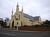
St Francis Xavier Cathedral
-
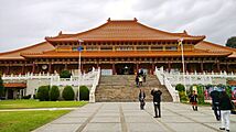
Nan Tien Temple


Wollongong is the third largest city in New South Wales. It is the tenth largest in Australia. The city is still growing. New homes are being built in areas like Dapto and around Albion Park.
| Wollongong Population Growth 1947–2010 (Statistical Local Area) | |||
|---|---|---|---|
| Year | Population | Increase | Growth |
| 1947 | 70,135 | ||
| 1954 | 100,725 | 30,590 | 43.6% |
| 1961 | 150,387 | 49,662 | 49.3% |
| 1966 | 177,432 | 27,045 | 18.0% |
| 1971 | 202,800 | 25,368 | 14.3% |
| 1976 | 222,250 | 19,450 | 9.6% |
| 1981 | 231,400 | 9,150 | 4.1% |
| 1986 | 232,240 | 840 | 0.4% |
| 1991 | 244,930 | 12,690 | 5.5% |
| 1996 | 255,740 | 10,810 | 4.4% |
| 2001 | 269,597 | 13,857 | 5.4% |
| 2006 | 277,984 | 8,387 | 3.1% |
| 2010 | 292,190 | 14,206 | 5.1% |
| Source: 1947–1996 2001–2010 | |||
Wollongong has a very diverse population. Many people from other countries came here for jobs at the Port Kembla steelworks after World War II. They settled in suburbs like Cringila and Warrawong. By 1966, about 60% of steelworks employees were born overseas. They came from over 100 countries. The University of Wollongong also attracts students and staff from all over the world.
About 20,000 people travel daily to jobs in Sydney. This makes it one of Australia's busiest commuter routes.
Education in Wollongong

Colleges and Universities
Wollongong has two campuses of the Illawarra Institute of TAFE. The Wollongong Campus is the largest. It offers many different courses.
The University of Wollongong is the city's university. It used to be part of the University of New South Wales. The university was named "Australian University of the Year" twice. It is known around the world. It has two main campuses: one on Northfields Avenue and the Innovation Campus.
Schools in Wollongong
Wollongong has many primary and high schools. These include public schools, religious schools, and independent schools.
Media and News
Wollongong has one daily newspaper, The Illawarra Mercury. It is published Monday to Saturday. Other free community newspapers are also published.
Wollongong gets television services from three main networks: WIN Television, the Seven Network, and Southern Cross 10. The Australian Broadcasting Corporation (ABC) and the Special Broadcasting Service (SBS) also broadcast here. Many new digital channels are also available. In some areas, you can even get Sydney channels. Foxtel (subscription TV) is also available.
- WIN Television has a local news show called WIN News every weekday at 5:30 pm. It is made in Wollongong.
- Southern Cross 10 shows short local news and weather updates.
- The Seven Network also airs short local news and weather updates.
Wollongong has five ABC radio services. There are also two commercial radio stations, i98FM and WAVE FM. Two community radio stations are Vox FM and 94.1 FM (Christian broadcaster).
In November 2021, the board game Monopoly launched a 'Wollongong' Edition. It features local attractions like the Nan Tien Temple and the Sea Cliff Bridge.
Getting Around Wollongong
Road Travel

The main road to Wollongong is the M1 Princes Motorway. This road goes down the escarpment via Mount Ousley Road. It enters the city near the University of Wollongong. Another freeway, Memorial Drive, goes north from the university. It connects Wollongong's northern suburbs and the scenic Lawrence Hargrave Drive. The Illawarra Highway connects Wollongong's southern suburbs to the Southern Highlands.
Train Travel

Wollongong is on the Illawarra railway line. Passenger trains connect Nowra and Kiama to the south. They also connect to Sydney in the north. A smaller line connects suburbs between the city center and Port Kembla. Wollongong railway station is the city's main train station.
Freight trains use this line to connect Sydney markets with Port Kembla. The Southern Highlands line is mainly for freight. It helps avoid traffic on Sydney's rail network.
Bus Travel
Bus services in Wollongong are run by Premier Illawarra and Dion's Bus Service. They also provide school and charter services. Wollongong railway station is the main bus hub. There is also a bus interchange near Wollongong University. Buses connect Wollongong suburbs to Shellharbour City Centre, Port Kembla, and Campbelltown. There is also a free shuttle bus. It connects the city center, university, and northern suburbs.
Air Travel

Wollongong is served by Shellharbour Airport. It is also called Illawarra Regional Airport or Wollongong Airport. The airport is in Albion Park Rail. This is 18 km (11 miles) south of Wollongong city center.
Flights to Melbourne (Essendon) and Brisbane started again in 2018. Fly Corporate operates these flights. There are also air charter businesses and helicopter services. The Historical Aircraft Restoration Society (HARS) is also based at the airport.
Port Activity
Wollongong uses Port Kembla harbour. It is a major place for exporting coal from New South Wales. The port has been upgraded to handle more ships. It now has a new Maritime Office. Many jobs have been created as port logistics grow.
The port has many berths for loading coal, grain, and other goods. A gas export terminal is also being built.

In 2023, the Australian Defence Department said Port Kembla is the most likely place to base future Australian nuclear-powered submarines.
Wollongong's Culture
Arts and Music

Wollongong has a lively arts scene. The city has various music and jazz groups. The Wollongong Conservatorium of Music teaches music for instruments and voice. It is one of Australia's largest regional conservatoriums. It is in the historic Gleniffer Brae Manor House. This house is part of the Wollongong Botanic Gardens.
The local professional theatre company is Merrigong Theatre Company. They are at the Illawarra Performing Arts Centre. Merrigong also manages the Wollongong Town Hall. Other local theatre groups include The Arcadians and The Phoenix Theatre.
The annual Wollongong Eisteddfod shows off local talent in music, theatre, and dance.

The Wollongong Art Gallery has a large collection of local art. It also has contemporary Australian, Aboriginal, and Asian art.
The band Tumbleweed formed in Wollongong in the 1990s. Surf-Rock duo Hockey Dad are also from here.
Yours and Owls Festival is a yearly music festival. It attracts 12,000 people. It features new Australian and international bands.
Cyrus Villanueva, who won The X Factor Australia in 2015, grew up in Wollongong.
Wollongong also hosts Wonderwalls. This is a yearly street art festival. It features local and international street artists.
Fun and Nightlife

Fun places include the Crown Street Mall. There are many restaurants, cafes, cinemas, and the Illawarra Performing Arts Centre. Next to WIN Stadium is the WIN Entertainment Centre. This place hosts concerts and sports events.
Many famous singers have performed at the WIN Entertainment Centre. These include Lady Gaga, Ed Sheeran, and Pink. Other venues like Anita's Theatre in Thirroul also host artists. Elton John performed at the nearby Wollongong Showground. The city has many nightclubs, pubs, and clubs. Most suburbs also have their own hotels.
Outdoor Activities
.jpg)
Wollongong has 17 beaches with lifeguards during certain seasons. These include Stanwell Park, Bulli, and North Wollongong. Surfing, fishing from rocks, swimming, and skimboarding are popular. The Wollongong to Thirroul Bike Track is 13 kilometers (8 miles) long. It runs along the coast. People use it for walking, jogging, skating, and biking. Bushwalking on Mount Keira and Mount Kembla is also popular.

Wollongong has many parks. MacCabe Park in the city center has a playground and a war memorial. Lang Park is next to the city beach. Stuart Park is north of the city. It is a popular spot for skydivers to land. It also has Norfolk Island Pines. J.J.Kelly Park is used by circuses. Beaton Park in Gwynneville has tennis courts, a leisure center, and a swimming pool.
Sports in Wollongong
Wollongong has two professional sports teams. The St George Illawarra Dragons play rugby league. The Illawarra Hawks play basketball.
Rugby League

Rugby league is the most popular sport in Wollongong. The St George Illawarra Dragons club plays in the NRL. The club was formed in 1999. They play half their home games at WIN Stadium in Wollongong. They won the 2010 NRL Grand Final.
Before the merger, the Illawarra Steelers played in the NSW Rugby League. They represented the area from 1982 to 1998. The Illawarra Steelers still play in junior competitions.
Rugby League has been played in Wollongong since 1911. Many international players have come from the area. Local teams play in the Illawarra Rugby League.
Basketball
The Illawarra Hawks basketball team plays in the NBL. They are the only NBL club to have played in every season since 1979. Home games are at the WIN Entertainment Centre. It is called "The Sandpit" because it is close to the beach. The Hawks won the 2001 NBL Championship.

Local basketball games are run by Basketball Illawarra. Their team, also called the Illawarra Hawks, plays in the Basketball NSW competition.
Football (Soccer)
Wollongong Wolves play in the National Premier Leagues NSW. This is the second-highest level of football in Australia. The club faced financial trouble in 2008 but was saved by community support. They are now a community-owned, not-for-profit organization. Illawarra Stingrays play in the National Premier Leagues Women’s, the second-highest level for women's football.
Other Sports
Wollongong does not have a senior cricket team. But there are two strong local competitions. Many Australian cricket players grew up here.
The Illawarriors are a rugby union club. They play in the Shute Shield competition. Local rugby union is played in the Illawarra Rugby Union.
Water polo has been played in Wollongong since 1894. It is now played at UOW Pool.
The Illawarra Cycling Club holds road cycle races almost every week. Velodrome racing also happens in summer. The club focuses on youth development.
The Gong Scorpions are the local Floorball team. They play socially and compete in the NSW Elite Series.
Baseball has been played in the region since 1938. Eight local clubs play in the Illawarra Baseball League.
The Wollongong Whales compete in winter swimming championships.
Other popular sports include golf, rock climbing, surfing, triathlon, and mountain biking.
In the book Quidditch Through the Ages, the Wollongong Warriors are an Australian Quidditch team. They invented the "Wollongong Shimmy." Wollongong Warriors is now a real club in Muggle quidditch.
Wollongong hosted the 2022 UCI Road World Championships in 2022.
AFL South Coast is a local Australian Rules Football competition.
Places to Visit

Besides many beaches, major places to visit in Wollongong include:
- Wollongong Botanic Gardens
- Cycling to Sandon Point from North Wollongong
- Wollongong Harbour (Belmore Basin), Wollongong Breakwater Lighthouse, Wollongong Head Lighthouse
- Illawarra Light Railway Museum (with train rides)
- Illawarra Museum
- Wollongong Town Hall
- Wollongong City Library
- Wollongong Art Gallery
- Bulli Tops (Sublime Point), Mount Keira, Port Kembla (Illowra Battery), Illawarra Fly Tree Top Walk
- Nan Tien Temple
- Hill 60 Port Kembla
- Fisherman’s Beach
- Science Centre and Planetarium
- WIN Stadium
Sister Cities
Wollongong has special relationships with these cities:
- Kawasaki, Japan (since 1988)
- Ohrid, North Macedonia (re-established 1999)
- Longyan, People's Republic of China (friendship city, since 2001)
Notable People from Wollongong
See also
 In Spanish: Wollongong para niños
