
Lake Illawarra facts for kids
Quick facts for kids Lake Illawarra |
|
|---|---|
| Illawarra Lake | |

Lake Illawarra, viewed from Sublime Point lookout, 2015.
|
|

Lake Illawarra
Location in New South Wales
|
|
| Location | Illawarra, New South Wales |
| Coordinates | 34°31′25″S 150°50′04″E / 34.52361°S 150.83444°E |
| Type | An open and trained intermediate wave dominated barrier estuary |
| Native name | Aboriginal (Tharawal): various adaptions of Elouera, Eloura, or Allowrie; Illa, Wurra, or Warra meaning pleasant place near the sea, or, high place near the sea, or, white clay mountain Error {{native name checker}}: parameter value is malformed (help) |
| Primary inflows | Macquarie Rivulet, Mullet Creek |
| Primary outflows | Tom Thumb Entrance, Tasman Sea |
| Catchment area | 238 km2 (92 sq mi) |
| Basin countries | Australia |
| Managing agency | Lake Illawarra Authority |
| Surface area | 35.8 km2 (13.8 sq mi) |
| Average depth | 2.1 metres (6 ft 11 in) |
| Water volume | 74,275 ML (2,623.0×106 cu ft) |
| Surface elevation | 0.3 metres (1 ft 0 in) AHD |
| Frozen | never |
| Settlements | Wollongong; Shellharbour |
Lake Illawarra is a large coastal lake in the Illawarra region of New South Wales, Australia. It is located about 100 kilometers (62 miles) south of Sydney. The local Aboriginal Tharawal people called it by names like Elouera, Eloura, or Allowrie. These names often mean "pleasant place near the sea," "high place near the sea," or "white clay mountain."
The lake is managed by the Lake Illawarra Authority. This group works to improve the lake's water quality and make its shores a nice place for recreation and tourism.
About Lake Illawarra
Lake Illawarra is found south of the city of Wollongong and north of Shellharbour. It is also about 5 kilometers (3 miles) northeast of Dapto. The lake gets its water from rivers like Macquarie Rivulet and Mullet Creek. These rivers flow from the Illawarra escarpment, bringing water from a large area of 238 square kilometers (92 square miles).
The lake is quite shallow, with an average depth of 2.1 meters (7 feet). It covers a surface area of 35.8 square kilometers (13.8 square miles). The deepest part of the lake is not specified, but its overall shallowness is due to sand filling in over time.
The lake connects to the Tasman Sea of the South Pacific Ocean through a narrow opening at Windang. In the past, this opening would often close off from the sea. This meant that nutrients and sediment would stay in the lake, and water levels would change a lot. In 2007, the Lake Illawarra Authority completed work to keep this entrance permanently open. This helps the lake stay healthier.
On the western side of the lake, at Yallah, is the Tallawarra Power Station. This power station uses natural gas to create electricity. It takes water from the lake for cooling. However, it has a special system to make sure the water returned to the lake is clean and safe.
Because Lake Illawarra is surrounded by the city of Wollongong, it can be affected by pollution and runoff from urban areas. Protecting the lake from these impacts is an ongoing effort.
Fun Activities at the Lake
Lake Illawarra is a popular spot for many outdoor activities. People enjoy:
- Fishing
- Prawning (catching prawns)
- Sailing
Many different types of birds live at the lake. You might see:
- Pelicans
- Cormorants
- Musk ducks
- Hoary-headed grebes
- Black swans
- Black ducks
- Grey teal ducks
- Herons
- Ibises
- Spoonbills
History of the Lake
The land around Lake Illawarra has a rich history. The traditional owners are the Aboriginal Tharawal and Wadi Wadi peoples. For them, Lake Illawarra was a very important source of food and had deep spiritual meaning.
Evidence like burial sites and middens (old heaps of shells and camp rubbish) found near Windang show that the Wadi Wadi people used this area a lot. They also held many important ceremonies and gatherings here. The name Illawarra comes from Aboriginal words that describe a "pleasant place near the sea," a "high place near the sea," or a "white clay mountain."
In March 1796, explorers Matthew Flinders and George Bass visited the lake in their small boat, the Tom Thumb. They named the lake "Tom Thumb's Lagoon" on Flinders' map.
Joseph Davis has written books about the history and environment of Lake Illawarra. His books share many details and old photographs of the lake and its surroundings. He also wrote about how two islands in the lake, Gooseberry and Hooka, were protected and became nature refuges.
Images for kids
-
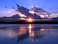
Sunset over Lake Illawarra, 2008
-
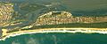
Entrance to Lake Illawarra, at Windang, 2008
-
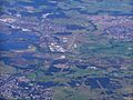
Aerial photo of Lake Illawarra, Albion Park and Albion Park Rail


