
Kawasaki, Kanagawa facts for kids
Quick facts for kids
Kawasaki
川崎市
|
|||
|---|---|---|---|
| Kawasaki City | |||

Kawasaki Daishi, Tama River, Lazona Kawasaki Plaza, Musashi-Kosugi area, Todoroki Athletics Stadium, Keihin industrial area
|
|||
|
|||

Location of Kawasaki in Kanagawa Prefecture
|
|||

Kawasaki
Location in Japan
|
|||
| Country | Japan | ||
| Region | Kantō | ||
| Prefecture | Kanagawa Prefecture | ||
| First official recorded | late 4th century | ||
| City Settled | July 1, 1924 | ||
| Area | |||
| • Total | 143.01 km2 (55.22 sq mi) | ||
| Population
(January 1, 2020)
|
|||
| • Total | 1,531,646 | ||
| • Density | 10,710.1/km2 (27,738.9/sq mi) | ||
| Time zone | UTC+9 (Japan Standard Time) | ||
| - Tree | Camellia | ||
| - Flower | Azalea | ||
| Phone number | 044-200-2111 | ||
| Address | 1 Miyamoto-chō, Kawasaki-ku, Kawasaki-shi, Kanagawa-ken 210-8577 | ||


Kawasaki (川崎市, Kawasaki-shi) is a large city in Kanagawa Prefecture, Japan. It is a major part of the Greater Tokyo Area and the Keihin Industrial Area. Kawasaki is the second most populated city in Kanagawa Prefecture, right after Yokohama. It is also the eighth most populated city in all of Japan.
As of October 1, 2017, Kawasaki had about 1,503,690 people living there. There were 716,470 households. The city is very crowded, with about 10,000 people per square kilometer. Kawasaki is special because it's the only city in Japan with over a million people that isn't a capital city of a prefecture. The total area of Kawasaki is about 142.70 square kilometers.
Contents
History
Early Beginnings
The earliest signs of people living in Kawasaki come from the Japanese Paleolithic and Jōmon period. These ancient findings are mostly in the northwest Tama Hills. Over time, the Tama River and the coast of Tokyo Bay have changed, making much of the city's land quite new geologically.
From Ancient Times to Feudal Lords
Around the 7th century, this area became part of the Musashi Province. During the Nara period, the main part of the Tachibana district was likely where the Takatsu district is today. From the Heian period onwards, the Inage clan controlled more land here.
A busy town grew around the Heiken-ji Buddhist temple, also known as Kawasaki-Daishi. This temple was founded in 1128. Between the Kamakura period and Sengoku period, smaller lords ruled the area. Eventually, it came under the power of the Later Hōjō clan.
The Edo Period and Growth
In 1611, a canal system called Nikaryō Yōsui was built by Koizumi Jidayū. This canal helped water the fields on the right side of the Tama River. Some parts of this old canal still run through the city today.
During the Edo period, important stations were built in the Kawasaki area. These stations were on the major Kaidō roads, the Tōkaidō and Nakaharakaidō. These roads were built by the Edo-Bakufu (the government at the time). The Kawasaki station (Kawasaki-juku) became an official stop on the Tōkaidō in 1623. The government also removed bridges over the Tama River, making people use ferries. This helped Kawasaki grow as a transport hub.
- Gallery
-
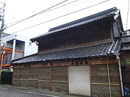
An old building in the "Kura-zukuri" style on Oyama Kaido street.
-
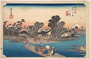
Rokugō no Watashi in the 1860s, photographed by Felice Beato.
-
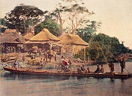
A ferry boat crossing the Rokugo River.


Modern Kawasaki
Kawasaki started growing very quickly in the Meiji and Taishō eras. This growth continues even today. In 1872, Kawasaki Station opened on the Tōkaidō Main Line. This was Japan's very first railway line.
In 1889, Kawasaki became a town (machi). On July 1, 1924, Kawasaki officially became an independent city (shi-). It had 48,394 people at that time. People from the Korean peninsula and Okinawa also came to Kawasaki to work in factories and help build railways and roads.
World War II
During World War II, Kawasaki was bombed by the United States Army Air Forces (USAAF) three times between April and July 1945. The worst attack was on April 15, 1945. These attacks destroyed about 35% of the city. About 1,520 people died and 8,759 were injured. The bombings burned down 9.3 square kilometers of the city. Kawasaki was a target because it had many heavy and chemical industries that supported the war.
Recent Times
After 1945, large parts of the city near the train station and industrial areas were rebuilt. Since the 1950s, new homes have been built in the northeastern part of the city. These areas are well-connected to Tokyo by new train lines.
On April 1, 1972, Kawasaki became a special "decree-designated city" (seirei shitei toshi) with five districts. By 1973, the population of Kawasaki grew to over one million people. Later, in 1982, two new districts, Miyamae and Asao, were created. As industries have changed, old factory areas are now being turned into new housing. This means Kawasaki's population is expected to keep growing.
Geography


Climate
Kawasaki has a humid subtropical climate (Cfa). This means it has hot, humid summers and mild winters.
| Climate data for Kawasaki (1991-2021 for everything apart from Sun Hours which is 1999-2019) | |||||||||||||
|---|---|---|---|---|---|---|---|---|---|---|---|---|---|
| Month | Jan | Feb | Mar | Apr | May | Jun | Jul | Aug | Sep | Oct | Nov | Dec | Year |
| Mean daily maximum °C (°F) | 8.7 (47.7) |
9.4 (48.9) |
12.6 (54.7) |
16.9 (62.4) |
21.2 (70.2) |
24.1 (75.4) |
27.7 (81.9) |
29.0 (84.2) |
26.0 (78.8) |
20.8 (69.4) |
15.8 (60.4) |
11.1 (52.0) |
18.6 (65.5) |
| Daily mean °C (°F) | 4.8 (40.6) |
5.5 (41.9) |
8.8 (47.8) |
13.6 (56.5) |
18.1 (64.6) |
21.4 (70.5) |
25.1 (77.2) |
26.3 (79.3) |
23.3 (73.9) |
17.9 (64.2) |
12.6 (54.7) |
7.5 (45.5) |
15.4 (59.7) |
| Mean daily minimum °C (°F) | 1.6 (34.9) |
2.2 (36.0) |
5.3 (41.5) |
10.4 (50.7) |
15.3 (59.5) |
19.2 (66.6) |
23.0 (73.4) |
24.2 (75.6) |
21.0 (69.8) |
15.5 (59.9) |
9.8 (49.6) |
4.4 (39.9) |
12.7 (54.8) |
| Average precipitation mm (inches) | 75 (3.0) |
79 (3.1) |
125 (4.9) |
117 (4.6) |
132 (5.2) |
165 (6.5) |
137 (5.4) |
112 (4.4) |
189 (7.4) |
206 (8.1) |
106 (4.2) |
65 (2.6) |
1,508 (59.4) |
| Average precipitation days | 5 | 7 | 9 | 8 | 9 | 10 | 9 | 9 | 10 | 9 | 7 | 5 | 97 |
| Average relative humidity (%) | 66 | 68 | 68 | 73 | 77 | 83 | 84 | 81 | 80 | 77 | 75 | 69 | 75 |
| Mean daily sunshine hours | 7.2 | 6.8 | 7.6 | 8.4 | 9.2 | 8.8 | 9.2 | 9.0 | 7.9 | 6.9 | 6.6 | 6.8 | 7.9 |
Where is Kawasaki Located?
Kawasaki is on the right side of the Tama River, which flows into Tokyo Bay. The city is a long, narrow strip of land. It sits between Tokyo to the northeast and Yokohama to the southwest. This makes Kawasaki a key part of the Greater Tokyo Area, which is one of the world's largest and most crowded urban areas.
The eastern part of Kawasaki, along Tokyo Bay, is a busy industrial area. It is part of the Keihin Industrial Zone. The western parts of the city, in the Tama Hills, are mostly residential areas. Many people who live here travel to work in Tokyo or Yokohama.
City Wards
Kawasaki is divided into seven smaller areas called ku (wards). Each ward has its own unique features.
| Name | Color | Map of Kawasaki | ||
|---|---|---|---|---|
| Rōmaji | Kanji | |||
| 1 | Asao-ku | 麻生区 | Leaf green |
Asao-ku
Kawasaki-ku
Miyamae-ku
Nakahara-ku
Saiwai-ku
Takatsu-ku
Tama-ku
|
| 2 | Kawasaki-ku (administrative center) |
川崎区 | Lime green | |
| 3 | Miyamae-ku | 宮前区 | Orange | |
| 4 | Nakahara-ku | 中原区 | Blue | |
| 5 | Saiwai-ku | 幸区 | Teal | |
| 6 | Takatsu-ku | 高津区 | Purple | |
| 7 | Tama-ku | 多摩区 | Pink | |

Neighboring Cities
Kawasaki shares borders with several cities. To the northeast, it borders parts of Tokyo like Ōta and Setagaya. To the northwest, it borders other Tokyo cities such as Komae and Chofu. To the southwest, it borders districts of Yokohama. Since 1997, with the opening of the Tokyo Bay Aqua-Line, Kisarazu, Chiba across Tokyo Bay also became a neighbor.
Rivers and Canals
Two main rivers flow through Kawasaki: the Tama River and the Tsurumi River. Many smaller streams and canals also join these rivers. The coastal area of Kawasaki has a network of canals that are important for industry and transport. The old Nikaryō Yōsui canal still exists inland.
Demographics
The population of Kawasaki has grown steadily over the last 70 years. Here's how it has changed:
| Historical population | ||
|---|---|---|
| Year | Pop. | ±% |
| 1940 | 300,777 | — |
| 1945 | 252,923 | −15.9% |
| 1950 | 319,226 | +26.2% |
| 1960 | 445,520 | +39.6% |
| 1965 | 632,975 | +42.1% |
| 1970 | 854,866 | +35.1% |
| 1975 | 973,497 | +13.9% |
| 1980 | 1,014,951 | +4.3% |
| 1985 | 1,088,624 | +7.3% |
| 1990 | 1,173,603 | +7.8% |
| 1995 | 1,202,820 | +2.5% |
| 2000 | 1,249,905 | +3.9% |
| 2005 | 1,327,011 | +6.2% |
| 2010 | 1,425,678 | +7.4% |
| 2015 | 1,475,213 | +3.5% |
| 2020 | 1,538,262 | +4.3% |
Sports
Kawasaki has many sports facilities for different activities.
Sports Facilities
Baseball
- Kawasaki Stadium: This stadium opened in 1952. It was once home to professional baseball teams. Today, it's used for American football and other events.
- Kawasaki Todoroki Baseball Stadium: This stadium can hold up to 5,000 people. It's often used for high school baseball games.
Field Athletics & Football
- Todoroki Athletics Stadium: Opened in 1964, this stadium can hold 25,000 people. It is the home stadium for the Kawasaki Frontale football team. It's also used for track and field events.
Indoor Facilities
- Kawasaki Prefectural Gymnasium: This gym opened in 1956. It's used for Puroresu matches and other events.
- Kawasaki Todoroki Arena: This arena hosts international field athletics and volleyball games. It also holds concerts and is home to the Kawasaki Brave Thunders basketball team.
Cycling & Horseracing
- Kawasaki Velodrome: A track for bicycle racing.
- Kawasaki Keiba: A place for horse racing.
Economy

Kawasaki is an important economic center. Many big companies have offices and factories here. For example, Fujitsu's main branch is in Nakahara-ku.
The city has many factories and research centers for heavy industry companies like JFE Group and Nippon Oil Corporation. It also has high-tech companies such as Fujitsu, NEC Corporation, Toshiba, Dell Japan, and Sigma Corporation.
Culture and Sights
Kawasaki offers many interesting places to visit, from ancient temples to modern museums.
Temples and Shrines

- Jōraku Temple (Jōraku-ji)
- Kanayama Shrine: Famous for its annual Kanamara Matsuri festival.
- Kawasaki Daishi (Heiken-ji): A very popular Buddhist temple. It is the second most visited temple in the Kantō region.
- Kotohira Shrine (Kotohira-jinja)
- Mikawari Fudō shrine
- Shinkō Temple (Shinkō-ji)
- Takaishi Shrine (Takaishi-jinja)
- Tenshōkō daijin shrine (Tenshōkō daijin)
Museums and Galleries


- Fujiko F. Fujio Museum: Also known as the Doraemon museum, it opened on September 3, 2011. It's in Tama-ku Ward.
- Kawasaki City Museum
- Nihon Minka-en Open Air Museum (Tama District): This museum has traditional Japanese farmhouses (minka) from different parts of Japan.
- Taro Okamoto Museum of Art
- Railway and bus museum
- Toshiba Museum
Music and Entertainment
- CLUB CITTA: A popular music venue.
- Myūza Kawasaki Symphonic Hall: Home to the Tokyo Symphony Orchestra.
- Yomiuri-Land EAST: An outdoor music theater.
Fun Places to Visit
- Kawasaki Racecourse
- Keirin cycle track Kawasaki
- Kawasaki Marien: A leisure center.
- Yomiuri Land: A large amusement park.
Parks
- Ikuta green space (Ikuta ryokuchi)
- Todoroki Ryokuchi: A large athletic park.
- Yumemigasaki Zoo (Yumemigasaki dōbutsu kōen): A local zoo.
Regular Events
- Daruma market in Shimo-Asao
- In Unity
- Kanamara Matsuri: A unique and famous festival.
- Kawasaki Citizens' Festival
- Kawasaki fantasy night
- Kawasaki Robot Congress
- Sannō festival at the Inage shrine
- Shin-Yuri art festival
- Tamagawa fireworks display
Other Places of Interest
- Kawasaki Warehouse: An amusement arcade designed to look like the old Kowloon Walled City.
- Koreatown: Eastern Kawasaki has a large community of Koreans in Japan.
- Nakagawa stable: A training stable for professional sumo wrestlers.
Transportation


Kawasaki has a very good transportation system, including many railway lines and highways.
Railway Stations
Kawasaki is served by several major railway companies, connecting it to Tokyo, Yokohama, and other areas.
- ■ East Japan Railway Company (JR East)
- Tōkaidō Main Line: Stops at Kawasaki Station.
- Keihin-Tōhoku Line: Stops at Kawasaki Station.
- Nambu Line: Connects Kawasaki Station to many other parts of the city.
- Tsurumi Line: Serves the industrial areas.
- Yokosuka Line / Shōnan-Shinjuku Line: Stops at Musashi-Kosugi and Shin-Kawasaki stations.
- ■ Odakyu Electric Railway
- Odakyū Line: Connects to areas like Noborito and Shin-Yurigaoka.
- Tama Line: Serves the western parts of Kawasaki.
- ■ Keio Corporation
- Sagamihara Line: Stops at Wakabadai and other stations.
- ■ Keikyu Corporation
- Keikyū Main Line: Stops at Keikyū Kawasaki Station.
- Daishi Line: Connects Keikyū Kawasaki to Kawasaki-Daishi temple.
- ■ Tokyu Corporation
- Tōyoko Line: Stops at Musashi-Kosugi and other stations.
- Meguro Line: Also stops at Musashi-Kosugi.
- Den-en-toshi Line: Serves areas like Mizonokuchi and Saginuma.
- Ōimachi Line: Runs through Futako-Shinchi and Takatsu.
Highways


Kawasaki has a network of expressways and national routes.
- Expressway
- Tōmei Expressway: Connects Tokyo to Nagoya. Tōmei-Kawasaki Interchange is in the city.
- Daisan Keihin Road: Connects Tokyo to Yokohama. Keihin-Kawasaki Interchange is in Kawasaki.
- Shuto Expressway Route K1 (Yokohane Route)
- Bayshore Route: Runs along the coast.
- Shuto Expressway Route K6 (Kawasaki Route)
- Tokyo Bay Aqua-Line: An expressway that crosses Tokyo Bay, connecting Kawasaki to Kisarazu, Chiba.
- National Route
- National Route 1 and 15: Important north-south highways.
- Japan National Route 246: Another key north-south highway.
- Japan National Route 132: A shorter highway connecting to the port.
- Japan National Route 357: An industrial highway.
- Japan National Route 409: Connects Takatsu-ku to Narita, Chiba.
International Relations
Kawasaki has friendly relationships with cities both in Japan and around the world. These are called "twin cities" or "friendship cities."
Twin Cities
Domestic Friendship Cities
 Fujimi, Nagano, since 1993
 Naha, Okinawa, since 1996
 Nakashibetsu, Hokkaido, since 1992
International Twin Cities
 Baltimore, Maryland, United States, since 1979
 Bà Rịa–Vũng Tàu province, Vietnam, since 2012
 Bucheon, Gyeonggi Province, South Korea, since 1996
 Lübeck, Germany, since 1992
- Milwaukee, Wisconsin, United States, since 1993
 Rijeka, Croatia, since 1977
 Salzburg, Austria, since 1992
 Sheffield, United Kingdom, since 1990
 Shenyang, Liaoning, China, since 1981
 Wollongong, New South Wales, Australia, since 1988
Friendship Ports
- Da Nang, Vietnam, since 1994
Notable People from Kawasaki
Many famous people come from Kawasaki, including:
- Koji Doi, professional wrestler
- Toshikazu Fukawa, actor
- Tomohiro Ishii, professional wrestler
- Osamu Kido, professional wrestler
- Kaoru Mitoma, footballer
- Michael Nakazawa, professional wrestler
- Yui Nītsu, singer, part of music duo Rythem
- Hajime Ohara, professional wrestler
- Kazuhiro Tamura, professional wrestler
- Ao Tanaka, footballer
- Natsuki Taiyo, professional wrestler
- Natsuko Tora, professional wrestler
- Yuyu-uta, YouTuber, entertainer, and musician
See also
 In Spanish: Kawasaki (Kanagawa) para niños
