
Da Nang facts for kids
Quick facts for kids
Da Nang
Đà Nẵng
|
||
|---|---|---|
|
Municipality (Class-1)
|
||
| City of Danang Thành phố Đà Nẵng |
||
|
City view at night
|
||
|
||
| Nicknames:
City of Han River
City of Bridges |
||
 |
||
| Country | ||
| Region | South Central Coast | |
| Seat | Hải Châu | |
| Subdivision | 6 districts, 2 rural districts | |
| Government | ||
| • Type | Municipality (Class-1) | |
| • Body | Danang People's Council | |
| Area | ||
| • Municipality (Class-1) | 1,284.73 km2 (496.04 sq mi) | |
| Population
(2023)
|
||
| • Municipality (Class-1) | 1.245.200 | |
| • Density | 960/km2 (2,500/sq mi) | |
| • Urban | 1.092.100 | |
| • Rural | 153.100 | |
| Ethnic groups | ||
| • Vietnamese | 99.47% | |
| • Katu | 0.16% | |
| • Hoa | 0.14% | |
| • Others | 0.23% | |
| Time zone | UTC+07:00 (ICT) | |
| Postal code |
50xxx
|
|
| Area codes | 236 | |
| ISO 3166 code | VN-DN | |
| License plate | 43 | |
| GRP (Nominal) | 2019 | |
| - Total | US$4.7 billion | |
| - Per capita | US$3.810 | |
| HDI (2022) | (5th) |
|
| Climate | Am | |
| International airports | Da Nang International Airport | |


Da Nang (Vietnamese: Đà Nẵng) is a large city in Vietnam. It is the fourth-largest city in the country based on its population. Da Nang is located on the coast of the East Sea of Vietnam, right where the Hàn River meets the sea. This makes it a very important port city for Vietnam.
It is one of five special cities in Vietnam that are directly controlled by the central government. Before 1997, Da Nang was part of a larger province. But on January 1, 1997, it became its own independent city. Da Nang is considered a "first-class city" and has many urban areas.
Da Nang is a major center for business and education in Central Vietnam. It has a good port that is easy to reach. Its location on important roads and railways makes it a key place for transportation. The city is also close to several amazing UNESCO World Heritage Sites. These include the old Imperial City of Huế, the historic town of Hội An, and the ancient Mỹ Sơn ruins.
In 2017, Da Nang hosted a big international meeting called APEC 2017. The city also has a very high Human Development Index, ranking fifth among all cities and provinces in Vietnam.
Contents
- What's in a Name? Understanding Da Nang's History
- A Look Back: The History of Da Nang
- Exploring Da Nang's Geography
- People and Population of Da Nang
- How Da Nang is Organized
- Da Nang's Economy: How the City Works
- Culture and Fun in Da Nang
- Learning in Da Nang: Education
- People of Da Nang: Ethnic Groups
- Getting Around: Da Nang's Transportation
- Da Nang's Global Connections
- See also
What's in a Name? Understanding Da Nang's History
| Da Nang | |
|---|---|
.svg)
"Da Nang" in chữ Nôm
|
|
| Vietnamese name | |
| Vietnamese alphabet | Đà Nẵng |
| Chữ Hán | 沱㶞 |
Most of the names for Da Nang tell us about its location. They often refer to its position at the mouth of the Hàn River. The name Da Nang likely comes from the Cham words da nak. This means "opening of a large river."
Other similar ideas for the name have been suggested. Some researchers think Da Nang might come from the Cham word daknan, meaning "the large water." Others connect it to the Raglai word danang, which means "river source."

Another name for Da Nang was Cửa Hàn. This means "mouth of the Han [river]". The French used the name Tourane, which is thought to be a simpler way of saying Cửa Hàn. This name, spelled "Cua han," even appears on old maps from 1650.
Other names for Da Nang include:
- Vũng Thùng: A common, old name still found in folklore.
- Trà Úc, Trà Áo, Trà Sơn, and Đồng Long Loan: These were literary names used by scholars.
- In Chinese, Da Nang is called Xiangang (峴港). This comes from an older name meaning "Clam Harbor."
- In chữ Nôm, an old Vietnamese writing system, "Đà Nẵng" was written as 沱灢.
- Thái Phiên: A name used for a short time after the 1945 August Revolution. It honored Thái Phiên, a leader of revolts in 1916.
A Look Back: The History of Da Nang
Ancient Times and the Champa Kingdom
The story of Da Nang began with the ancient kingdom of Champa. This kingdom was formed in 192 AD. At its strongest, Champa's power reached from Huế to Vũng Tàu. The city of Indrapura, near modern-day Dong Duong village (about 50 km from Da Nang), was Champa's capital from about 875 to 1000 AD.
Other important Cham sites were also in the Da Nang area. These included Singhapura ("City of the Lion") and the valley of Mỹ Sơn. Many old temples and towers can still be seen at Mỹ Sơn today.
In the late 900s, the kings of Indrapura fought with the Đại Việt. The Đại Việt were based near modern Hanoi. Champa tried to expand north and even invaded Đại Việt in 979. However, they failed due to strong Vietnamese defense. In 982, Đại Việt attacked Indrapura, defeating the Cham King. Because of these problems, the Cham left Indrapura around 1000 AD.
The Đại Việt continued to expand south for centuries. This was known as Nam Tiến. By the end of the 1400s, they had taken over most of the Cham lands.
The Điện Hải Citadel was first built in 1813. It was an earthen fort to protect the port. By 1819, both Điện Hải and An Hải citadels were rebuilt with bricks. In 1823, Emperor Minh Mạng rebuilt Điện Hải fortress on a higher spot. It became a stronger citadel in 1835.
Early European Contact
One of the first Europeans to visit Da Nang was a Portuguese explorer named António de Faria. He arrived in 1535. Thanks to him, Portuguese ships started visiting Hội An regularly. Hội An was a more important port than Da Nang back then.
Throughout the 1600s and 1700s, French and Spanish traders and missionaries also visited Hội An. An American ship arrived in Da Nang (then called Tourane) in 1819. However, trade was difficult because the country was recovering from wars.
In 1835, Emperor Minh Mạng made a rule. European ships could only trade at Da Nang. This quickly made Da Nang's port more important than Hội An.
French Colonial Rule (French Indochina)
In 1847, French ships attacked Da Nang. They said it was because Roman Catholic missionaries were being treated badly. In August 1858, French troops landed in Da Nang again. This was part of a military campaign ordered by Napoleon III.
The French took over the city. But the Vietnamese army quickly surrounded them. The French were forced to leave in March 1860. Later, the French invaded southern Vietnam. In 1862, some southern provinces were given to the French.
-
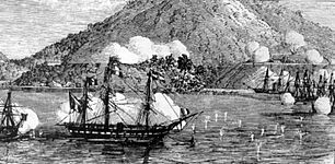
French warships near Da Nang in September 1858.
-
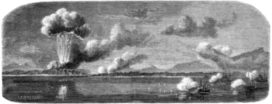
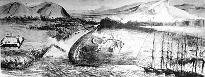
French and Spanish forces bombing An Hải and Điện Hải citadels.
-
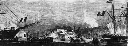
French and Spanish forces landing on the Hàn River in Da Nang, September 1858.
-
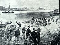
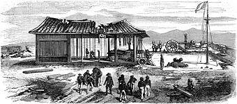
French marines landing in Da Nang.
-
Điện Hải citadel after being bombed in 1858.
-
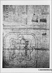
A plan of An Hải citadel from 1831.
-
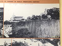
An Hải citadel (left) and Điện Hải citadel (right) with French warships.
-
A French hospital and chapel built in Dien Hai citadel in the early 1900s.


_c%E1%BB%A7a_tri%E1%BB%81u_%C4%91%E1%BA%A1i_Minh_M%E1%BA%A1ng.jpg)


Over the next twenty years, the French gained more control over Vietnam. In 1887, they created French Indochina. In 1889, the French renamed the city Tourane. It became one of the five main cities in Indochina.
In 1903, a tramway was built in the city. It opened to the public in 1907. This tramway connected areas like Montagne de Marbre (Marble Mountains) and operated until 1915.
The Vietnam War Era

During the Vietnam War, the area that is now Da Nang International Airport was a very important air base. It was used by both the South Vietnamese and United States Air Force.
This base became one of the busiest airports in the world during the war. In May 1968, it had over 2,500 aircraft movements every day. This was more than any other airport or air base at that time. The last U.S. ground combat operations in Vietnam ended in Da Nang on August 13, 1972.
After the U.S. left, Da Nang fell to the communist forces on March 29–30, 1975. Vietnam later issued special stamps to remember this event. The Marble Mountain Air Facility, built in 1965, was also located in Da Nang.
Da Nang Today
Since 1975, Da Nang has become a very important city in central Vietnam. It is now considered the third most important urban center after Ho Chi Minh City and Hanoi. Da Nang has many schools and is a key place for the economy.
Exploring Da Nang's Geography
.png)
Da Nang is the largest city in central Vietnam. It is also one of the country's most important ports. Mountains surround the city to the west. The East Sea is to the east.
To the north, Da Nang borders Thừa Thiên-Huế Province across the Hải Vân Pass. To the south and west, it borders Quảng Nam Province. Da Nang is about 764 km south of Hanoi and 964 km north of Ho Chi Minh City. The city covers a total area of about 1,283 square kilometers.
Land and Landscape
Da Nang's land is shaped by the Annamite mountain range in the north and northwest. These mountains have peaks between 700 and 1500 meters high. To the south and east, there are flat coastal plains with white sand beaches.
Weather and Climate
Da Nang has a tropical monsoon climate. This means it has two main seasons:
- A typhoon and wet season from September to December.
- A dry season from January to August.
The average temperature in Da Nang is around 26°C (79°F). It can get a bit cooler sometimes, but not for long. Temperatures are highest from June to August, averaging 28°C to 30°C (82-86°F). They are lowest from December to February, averaging 18°C to 23°C (64-73°F). The humidity is usually around 81%.
Da Nang gets about 2205 mm (87 inches) of rain each year. Most of the rain falls between September and November. The driest months are February to April. The city gets about 2162 hours of sunshine annually.
| Climate data for Da Nang | |||||||||||||
|---|---|---|---|---|---|---|---|---|---|---|---|---|---|
| Month | Jan | Feb | Mar | Apr | May | Jun | Jul | Aug | Sep | Oct | Nov | Dec | Year |
| Record high °C (°F) | 34.5 (94.1) |
37.0 (98.6) |
39.9 (103.8) |
40.7 (105.3) |
41.5 (106.7) |
40.4 (104.7) |
40.6 (105.1) |
40.2 (104.4) |
38.6 (101.5) |
35.8 (96.4) |
32.8 (91.0) |
31.2 (88.2) |
41.5 (106.7) |
| Mean daily maximum °C (°F) | 25.0 (77.0) |
26.2 (79.2) |
28.3 (82.9) |
31.0 (87.8) |
33.3 (91.9) |
34.5 (94.1) |
34.4 (93.9) |
33.9 (93.0) |
31.8 (89.2) |
29.5 (85.1) |
27.4 (81.3) |
25.1 (77.2) |
30.0 (86.0) |
| Daily mean °C (°F) | 21.5 (70.7) |
22.4 (72.3) |
24.2 (75.6) |
26.5 (79.7) |
28.4 (83.1) |
29.4 (84.9) |
29.3 (84.7) |
29.0 (84.2) |
27.6 (81.7) |
26.0 (78.8) |
24.4 (75.9) |
22.2 (72.0) |
25.9 (78.6) |
| Mean daily minimum °C (°F) | 19.3 (66.7) |
20.2 (68.4) |
21.8 (71.2) |
23.8 (74.8) |
25.2 (77.4) |
26.0 (78.8) |
25.7 (78.3) |
25.6 (78.1) |
24.5 (76.1) |
23.5 (74.3) |
22.1 (71.8) |
20.0 (68.0) |
23.1 (73.6) |
| Record low °C (°F) | 10.2 (50.4) |
13.1 (55.6) |
12.7 (54.9) |
16.7 (62.1) |
20.6 (69.1) |
21.6 (70.9) |
21.1 (70.0) |
20.4 (68.7) |
19.8 (67.6) |
15.1 (59.2) |
13.3 (55.9) |
9.2 (48.6) |
9.2 (48.6) |
| Average rainfall mm (inches) | 81.9 (3.22) |
23.6 (0.93) |
25.0 (0.98) |
35.3 (1.39) |
81.1 (3.19) |
82.6 (3.25) |
92.5 (3.64) |
141.2 (5.56) |
350.7 (13.81) |
628.0 (24.72) |
448.2 (17.65) |
218.4 (8.60) |
2,205 (86.81) |
| Average rainy days | 12.0 | 5.6 | 4.8 | 5.4 | 9.2 | 8.1 | 9.4 | 11.6 | 14.6 | 20.0 | 20.3 | 18.7 | 139.1 |
| Average relative humidity (%) | 84.2 | 83.9 | 83.7 | 82.7 | 79.3 | 76.4 | 75.8 | 77.4 | 82.1 | 84.4 | 84.7 | 85.4 | 81.7 |
| Mean monthly sunshine hours | 131.9 | 146.0 | 182.3 | 208.6 | 246.7 | 242.3 | 246.2 | 214.8 | 177.4 | 143.4 | 117.7 | 94.8 | 2,162.6 |
| Source 1: Vietnam Institute for Building Science and Technology | |||||||||||||
| Source 2: The Yearbook of Indochina | |||||||||||||
People and Population of Da Nang
Da Nang is the fifth most populated city in Vietnam. In 2022, it had a population of about 1,220,187 people. More than half of the population (50.7%) are women.
How Da Nang's Population is Growing
Da Nang's population has been growing quite fast. Between 2005 and 2011, it grew by 2.5% to 3% each year. This is much faster than the national average of 1% to 1.2%. The city's population was expected to reach one million people by 2014.
Many people move to Da Nang from other places. This "in-migration" has been a big reason for the city's growth. Since 2009, the number of people moving in has been over 2% each year.
The number of births in Da Nang is also slightly higher than the national average. In 2011, there were about 18 births for every 1000 people. The average life expectancy in Da Nang is about 74.8 years.
City Life: Urbanization in Da Nang
Da Nang has a very high rate of urbanization. This means a large part of its population lives in city areas. In fact, it has the highest urbanization rate among all provinces and cities in Vietnam. As of 2009, almost 87% of Da Nang's people lived in urban areas.
How Da Nang is Organized
The city of Da Nang is divided into eight main areas. Six of these are urban districts, which are like city neighborhoods. These are Hải Châu, Thanh Khê, Cẩm Lệ, Sơn Trà, Ngũ Hành Sơn, and Liên Chiểu.
There are also two rural districts: Hòa Vang and Hoàng Sa (Paracel Islands). These districts are further divided into smaller parts called wards and communes. The main city center of Da Nang is the Hải Châu district.
As mentioned before, Da Nang became an independent city in 1997. Before that, it was part of Quang Nam–Da Nang Province.
| District | Subdivisions | Area | Population (2018) | Pop. density | ||
|---|---|---|---|---|---|---|
| (km2) | (mile2) | (persons/km2) | (persons/mile2) | |||
| Cam Le | 6 wards | 33.3 km2 | 12.9 sq mi | 143,632 | 2,054.74/km2 | 5,321.8/sq mi |
| Hai Chau | 13 wards | 24.1 km2 | 9.3 sq mi | 221,324 | 9,251.11/km2 | 23,960.3/sq mi |
| Hoa Vang | 11 communes | 737.5 km2 | 284.8 sq mi | 201,070 | 151.14/km2 | 391.5/sq mi |
| Lien Chieu | 5 wards | 83.1 km2 | 32.1 sq mi | 170,153 | 1,144.54/km2 | 2,964.3/sq mi |
| Ngu Hanh Son | 4 wards | 36.5 km2 | 14.1 sq mi | 115,872 | 1,476.41/km2 | 3,823.9/sq mi |
| Son Tra | 7 wards | 60.8 km2 | 23.5 sq mi | 173,455 | 1,970.58/km2 | 5,103.8/sq mi |
| Thanh Khe | 10 wards | 9.3 km2 | 3.6 sq mi | 205,341 | 18,046.06/km2 | 46,739.1/sq mi |
| Hoàng Sa | — | 305 km2 | 118 sq mi | 0 | 0/km2 | 0/sq mi |
| Total | 45 wards, 11 communes | 1,479.1 km2 | 571.1 sq mi | 1,230,847 | 628.58/km2 | 1,628.0/sq mi |
Da Nang's Economy: How the City Works
Da Nang is a major industrial center in central Vietnam. Its economy is strong. In 2007, the average income per person was high compared to other parts of Vietnam. By 2009, this income had increased even more.
Da Nang has often ranked high in a survey called the Provincial Competitiveness Index. This survey looks at how easy it is to do business in different provinces. Da Nang does well because it has good infrastructure, trained workers, and clear rules.
In 2023, Da Nang scored well on this index again. It got high marks for "Informal Charges" (meaning fewer hidden fees) and "Law and Order."
| Exports | million US$ (2007) | Imports | million US$ (2007) |
|---|---|---|---|
| Total | 469.6 | Total | 522.1 |
| Textiles | 139.8 | Machinery, equipment | 237.2 |
| Aquatic products | 75.2 | Materials for garments | 77 |
| Handicraft products | 51.6 | Iron, steel | 41.6 |
| Coffee | 47.6 | Medicaments | 24.9 |
| Footwear | 17.7 | Chemical fertilizer | 22.5 |
| Rice | 8 | Motorbikes | 0.45 |
Exports from Da Nang grew to US$575 million in 2008. However, they dropped to US$475 million in 2009.
Farming, Fishing, and Forests
Even though Da Nang is a city, many people work in farming, fishing, and forestry. In 2007, about 37,800 people worked in these areas. They produced a lot of rice and fish.
However, fewer people have been working in these jobs over the past decade. Fishing is more important to Da Nang's economy than farming. This is because the city has little farmland but is located on the coast.
Industry and Manufacturing
Da Nang has many different types of industries. These include making machinery, electrical goods, chemicals, and textiles. They also build ships. Some products made here are fabric, clothes, bricks, and soap.
In 2007, government-owned businesses made up most of Da Nang's industrial output. Industry in Da Nang grew by almost 15% each year from 2000 to 2007. This made it a main driver of the city's economic growth. The number of jobs in industry also grew.
Shopping and Trade

The main marketplace in Da Nang is the Hàn Market. It is located downtown, near the Hàn River. This market is like other big markets in Vietnam. It offers many different items from various sellers.
You can find clothes, silk, jewelry, and flowers. There are also foods like dried fruit and fish. You can buy coffee, tea, and even Vietnamese snake wine here.
New Buildings and Development
Many new buildings are being constructed in Da Nang. These include fancy beachfront resorts. One example is the Hyatt Regency Danang Resort & Spa. There is also a large Beach Resort complex with villas and a Marriott Hotel.
Another big project is the Da Phuoc International New Town. This project is building a whole new urban area on land that has been reclaimed from the sea. This will be the first big land reclamation project in Central Vietnam. Plans for this area include hotels, apartments, offices, a golf course, a marina, and international schools.
Culture and Fun in Da Nang
Tourism and Sightseeing


Tourism is a very important part of Da Nang's economy. The city is a travel hub for central Vietnam. It is also close to several UNESCO World Heritage Sites. These include the Imperial City of Hue, the old town of Hoi An, and the My Son ruins. These sites attract many tourists.
Mỹ Sơn is an archaeological site that is over a thousand years old. It is in Quang Nam, about 70 km west of Da Nang. This was once a capital and religious center for the Champa kingdom. It had over 70 temples and towers. Even though it was damaged in the 1960s, more than 20 structures still stand. It became a UNESCO World Heritage Site in 1999. Many statues and artworks found at Mỹ Sơn are now in the Museum of Cham Sculpture in Da Nang.
The Marble Mountains are rocky hills made of limestone. They rise out of the beach just south of Da Nang. You can find paths leading to the top of these hills. From there, you can see great views of Non Nuoc Beach and the South China Sea. The caves in these hills were once home to the Cham people. Later, the Nguyen dynasty built many pagodas (temples) among the caves. At the base of the Marble Mountains, in Non Nuoc Village, artisans create sculptures and artwork.
Non Nuoc Beach is a beautiful white sandy beach near Da Nang. It was a popular place for American troops to relax during the Vietnam War. Today, this beach and Mỹ Khê beach are home to fancy resorts and places for surfing. Ba Na Hills is a mountain resort with a long cable car system. This cable car takes visitors up to the peak of Ba Na, which is 1487 meters above sea level. Son Tra Mountain is also close to the city center. It has wild streams and resorts along the coast.
In 2017, Da Nang saw a big increase in international tourists. About 6.6 million visitors came to Da Nang that year. This was a 19% increase from the year before. The city earned over US$853 million from tourism in 2017.
Da Nang has received many awards and recognitions. In 2016, it was voted one of the top 10 resort destinations in Asia. In 2018, it was listed as a place to visit before it becomes too famous. The Golden Bridge became very famous around the world in 2018. In 2019, The New York Times called Da Nang "the Miami of Vietnam."
Delicious Food: Da Nang's Cuisine
Central Vietnamese food, especially from Da Nang, is very famous in Vietnam. It is also becoming more popular around the world. Da Nang is known for its tasty dishes. Some popular ones include:
- Mì Quảng: A noodle dish.
- Bún chả cá: Fish ball noodle soup.
- Bánh tráng cuốn thịt heo: Dry pancake rolls with pork.
- Banh xeo: Crispy pancakes.
- Nem lui: Lemongrass pork skewers.
Sports in Da Nang

Da Nang has a football (soccer) club called SHB Da Nang F.C.. They play in the V. League 2, which is Vietnam's second-highest professional football league. They were once champions of the top league in 2009. They also won the Vietnamese Cup that same year.
Several players from SHB Da Nang F.C. also play for the national team. The team plays its home games at the Chi Lăng Stadium. This stadium can hold 30,000 people.
Learning in Da Nang: Education

Da Nang has several universities. They have campuses in many parts of the city and nearby regions.
Some of the universities include:
- University of Da Nang: This university has many different colleges, like Technology, Economics, and Foreign Languages.
- Da Nang University of Medical Technology, Medicine and Pharmacy
- Da Nang University of Sport
- Duy Tan University: A private university.
- Dong A University: Another private university.
- Da Nang University of Architecture
- The American University of Vietnam (AUV): A private university.
The city also has 17 high schools. Le Quy Don High School for the Gifted is one of the best high schools in Vietnam.
There are also many international education groups in Da Nang. For example, Campus France helps students learn French and find study opportunities in France. The English Language Institute helps people learn English and offers IELTS tests. The Singapore International School is an international school in Da Nang.
People of Da Nang: Ethnic Groups
Da Nang is home to over 37 different ethnic groups and people from other countries. The largest group is the Kinh ethnic group, with over 883,000 people. The Chinese are the second largest group, with about 2,974 people.
Other minority ethnic groups include the Co Tu, Tay, Ede, Muong, and Gia Rai. Some smaller groups, like the Chơ Ro, Hani, Si La, and Ơ Đu, have only a few people living in the city.
Getting Around: Da Nang's Transportation

Da Nang is at the end of the East–West Economic Corridor (EWEC). This corridor connects Vietnam, Laos, Thailand, and Burma. The city is working with Yokohama City, Japan, to improve its transportation system.
Travel by Air

Da Nang International Airport is in the middle of the city. It is the third largest international airport in Vietnam. It is an important way to get to central Vietnam. During the Vietnam War, this airport was known as Da Nang Air Base. It was one of the busiest airports in the world.
As of June 2011, the airport had flights to many Vietnamese cities. It also had international flights to places like Seoul (South Korea), Tokyo (Japan), Singapore, and Taipei (Taiwan). In December 2011, a new international terminal opened. This allowed for more flights to places like Cambodia, Thailand, Hong Kong, Japan, and Australia. The airport has been updated and improved since then.
Travel by Land


Da Nang is a major stop on the North–South Railway. This railway is also called the Reunification Express.
Important highways, National Highway 1 and 14B, pass through Da Nang. These roads connect the city to Hanoi in the north and Ho Chi Minh City in the south. They also link to the Central Highlands and Laos to the west.
The Hai Pass is a mountain pass that separates Da Nang from Thừa Thiên Huế Province. Highway 1A goes through this pass. To make travel faster and safer, the Hải Vân Tunnel was built. It opened in 2005. It is the longest tunnel in Southeast Asia, at 6.28 km. This tunnel saves travelers a lot of time. An expressway between Da Nang and Quang Ngai was finished in 2018.
Several bridges cross the Han River in Da Nang. These include the famous Han River Bridge, Tran Thi Ly Bridge, and the Thuan Phuoc Bridge. The Thuan Phuoc Bridge is the longest suspension bridge in Vietnam. The Dragon River Bridge also crosses the Han River. It helps tourists get from the airport to the beaches more directly.
Travel by Sea

Da Nang's port system is the third largest in Vietnam. It is smaller only than the ports in Ho Chi Minh City and Haiphong. In 2008, Da Nang's port handled 2.7 million tons of goods. This included exports, imports, and domestic cargo. Over 29,600 passengers also passed through the port in 2008.
The port system has two main areas: Tiên Sa Seaport and Song Hàn Terminal. Tiên Sa Seaport is deep enough for large ships and cruise ships. Song Hàn Terminal can handle smaller vessels. The number of large cruise ships visiting Da Nang Port has increased in recent years. In just the first two months of 2010, 12 cruise ships docked there.
Cruise ships also dock at Chân Mây Port. This port is about 50 km from Da Nang, accessible through the Hải Vân Tunnel.
Da Nang's Global Connections
Sister Cities
Da Nang has "sister city" relationships with many cities around the world. This means they share cultural and economic ties.
 Battambang, Cambodia
 Champasak, Laos
 Changwon, South Korea
- Daegu, South Korea
 Haiphong, Vietnam
 Khon Kaen, Thailand
 Kunming, China
- Mukdahan, Thailand
 Oakland, United States
- Pittsburgh, United States
- Savannakhet, Laos
 Tangier, Morocco
 Timișoara, Romania
 Toluca, Mexico
Cooperation and Friendship
Da Nang also works closely with other regions and cities.
- Attapeu, Laos
 Borås, Sweden
 Grodno Region, Belarus
- Hwaseong, South Korea
- Houston, United States
 Kolkata, India
 Košice, Slovakia
 Macau, China
 Nantes, France
 Newcastle, Australia
- Nord Pas de Calais, France
- Queensland, Australia
 Rotterdam, Netherlands
 Sakai, Japan
- Salavan, Laos
 Salo, Finland
- Sekong, Laos
- Shandong Province, China
- South Australia, Australia
 Stuttgart, Germany
- Surat, India
 Walloon Region, Belgium
 Yaroslavl Oblast, Russia
Friendship Port
- Kawasaki, Japan
Consulates General
Some countries have official offices in Da Nang to help their citizens and promote relations. These include:
- People's Republic of China
- Japan
- Republic of Korea
- Lao People's Democratic Republic
- The Russian Federation
See also
 In Spanish: Đà Nẵng para niños
