
Vũng Tàu facts for kids
Quick facts for kids
Vũng Tàu
Thành phố Vũng Tàu
|
|
|---|---|
| City of Vung Tau | |
|
Clockwise from top: Front Beach skyline, Thích Ca Phật Đài, Bạch Dinh (vi), Christ of Vũng Tàu, Long Sơn Mansion (vi)
|
|
| Country | |
| Province | Bà Rịa–Vũng Tàu province |
| Area | |
| • Land | 141.1 km2 (54.5 sq mi) |
| Population
(2022)
|
|
| • Total | 464.860 |
| • Density | 3.296/km2 (8.54/sq mi) |
| • Ethnicities |
|
| GDP (PPP, constant 2015 values) | |
| • Year | 2023 |
| • Total | $14.7 billion |
| • Per capita | $32,400 |
| Time zone | UTC+7 (Indochina Time) |


Vũng Tàu is the biggest city in Bà Rịa–Vũng Tàu province in southern Vietnam. It's a very important place for business, money, and culture. It's also a popular spot for tourists in southern Vietnam. The city covers about 141.1 square kilometers. It has 16 urban areas called wards and one commune on Long Sơn Island. Vũng Tàu used to be the capital of the province until 2012. The city is also a main center for getting crude oil from the ground in Vietnam.
Contents
City Areas and Divisions
Since April 2015, Vũng Tàu has 16 wards: 1, 2, 3, 4, 5, 7, 8, 9, 10, 11, 12, Thắng Nhất, Thắng Nhì, Thắng Tam, Nguyễn An Ninh, and Rạch Dừa. It also has one commune called Long Sơn.
These wards are divided into smaller areas called quarters. The commune is divided into hamlets.
A Look Back: Vũng Tàu's History


Early Times
People have lived in the Vũng Tàu area for a very long time. Archeologists found signs of humans from about 2000 BCE on Long Sơn island. They found old burial sites, tools, pots, and jewelry. These items show that people here traded with other cultures.
For many centuries, Vũng Tàu was part of ancient kingdoms like Funan and Chenla. Not much is known about Vũng Tàu during these times.
In 1295, a Chinese diplomat named Zhou Daguan passed by Vũng Tàu. He wrote about it as "Zhenpu," which he said was the border of the Chenla kingdom.
How Vũng Tàu Got Its Name
In the 14th and 15th centuries, the area that is now Vũng Tàu was a swamp. European trading ships often visited this cape. Because so many ships anchored here, the place became known as Vũng Tàu. This name means "anchorage" or "ship bay."
The Portuguese called it Cinco Chagas on their maps. Later, the French named it Cap Saint-Jacques. Today, a cliff in Vũng Tàu is called Mũi Nghinh Phong, which means "Cape of greeting the wind."

Vietnamese People Settle Here
During the 16th and 17th centuries, many Vietnamese people moved to the coastal area near Vũng Tàu. They were escaping conflicts in other parts of Vietnam.
Vũng Tàu was first known as Tam Thắng, meaning "Three Boats." This name honored the first three villages in the area: Thắng Nhất, Thắng Nhị, and Thắng Tam. These villages were part of Biên Hòa province.
Around 1822, King Gia Long sent soldiers to deal with pirates who were causing trouble for traders. The soldiers won, and they were given land to live on. This helped protect the area. The villages grew and became important for defense.
Kings Gia Long, Minh Mạng, and Thiệu Trị built many defense structures in Vũng Tàu. A military fort called Phước Thắng was built in 1839. It had six bronze cannons to protect the area.
French Influence
In 1859, Vietnamese soldiers used cannons from the Phước Thắng fort to fire at French ships. This was an important moment in Vietnam's fight against French invaders.
In 1876, Vũng Tàu became part of Bà Rịa county under French rule. There were talks about moving Saigon's port to Vũng Tàu, but it didn't happen.
On May 1, 1895, the French government made Cap Saint Jacques (Vũng Tàu) an independent town. It was later merged and re-divided with Bà Rịa county. By 1901, Vũng Tàu had a population of 5,690 people. Many of them were immigrants from northern Vietnam. Most people worked in fishing, farming, and services.
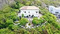
Between 1885 and 1934, the French designed the city center along the Front Beach. They built important buildings like the Post Office and the Grand Hotel. In 1898, the French governor, Paul Doumer, built a famous house called Villa Blanche in Vũng Tàu.
A national road was built in 1896, connecting Vũng Tàu with Saigon. A jetty was also built at the Front Beach.
During the Wars
During the First Indochina War, Vũng Tàu had a military hospital used by French soldiers. In 1952, a serious incident occurred at a rest center, resulting in casualties among French officers and Vietnamese civilians.
After 1954, many people from northern Vietnam moved to Vũng Tàu. The city's location near Saigon made it a key defense spot. The Army of the Republic of Vietnam built many training centers here.
During the Vietnam War, Vũng Tàu was a base for Australian and American military units. It also became a popular place for soldiers to rest and relax. Because of its military importance and popularity as a resort, Vũng Tàu's population grew a lot during the war.
Changes After the War
In April 1975, Vũng Tàu saw significant changes as the conflict in southern Vietnam ended. The city's control shifted, and a new government was established.
After Vietnam was reunified, Vũng Tàu became a city under the new government. In 1976, Vũng Tàu was merged with other areas to form Đồng Nai province.
After the war, many people faced economic difficulties. Vũng Tàu became a common starting point for "Vietnamese boat people" – refugees who left Vietnam seeking better lives.
A Special Zone for Oil
When oil was found in the waters near southern Vietnam, the government decided to develop it. In 1979, Vũng Tàu was combined with Côn Đảo Islands to create the Vũng Tàu-Côn Đảo Special Zone. This was done to help the new oil industry grow.
Between 1980 and 1982, Vũng Tàu changed a lot. It became a hub for oil services and logistics. Many engineers and workers moved to the city. A large port area was built to handle oil products and materials.
When Vietnam and the Soviet Union started a joint oil company called Vietsovpetro, many Soviet experts came to Vũng Tàu. A special dormitory was built for them in 1985. Today, many Russian families still live there.
Becoming a Provincial City Again
In 1991, the Special Zone was ended. Bà Rịa–Vũng Tàu province was created, and Vũng Tàu became a city again.
Thanks to economic reforms and profits from seafood and oil, Vũng Tàu province grew quickly. The city's economy expanded greatly.
Tourism and industry also started to do very well. In 1996, the Dong Xuyen Industrial Park opened.
In the late 1990s and 2000s, Vũng Tàu transformed. Many roads were improved, and new projects were built. New bridges helped connect Vũng Tàu with nearby areas faster.
Many new shopping centers and urban areas were built, like the Vung Tau City Commercial Centre. In 2012, the main government offices for the province moved to Bà Rịa.
Economy and Tourism in Vũng Tàu
Shipping and Oil
Vũng Tàu is located on a small peninsula in southern Vietnam. It has always been an important port, especially during the time of French rule.
Today, Vũng Tàu is still very important for Vietnam's offshore oil industry. It's the only place in Vietnam where crude oil and natural gas are extracted. This industry brings a lot of money to Vietnam.
Local Industries
Companies like PEB Steel have factories in Vũng Tàu.
Beautiful Beaches
Vũng Tàu has four large and beautiful beaches:
- Back Beach (Bãi Sau)
- Front Beach (Bãi Trước)
- Strawberry Beach (Bãi Dâu)
- Pineapple Beach (Bãi Dứa)
Fun Resorts and Parks
Big plans are in the works for Vũng Tàu! A huge resort project called Saigon Atlantis is planned. It will have resorts, shops, and sailing. There are also plans for a Vũng Tàu Aquarium and a Disneyland-like entertainment park called Bàu Trũng.
Vũng Tàu's Culture
Vũng Tàu has a rich and varied culture. This is because of its location and its history of different influences and people moving there.
Local Traditions and Festivals
As a city by the sea, Vũng Tàu's culture is strongly linked to the ocean. People from the original Tam Thắng villages often celebrate special temple feasts once a year.
Fishermen in the area also celebrate holidays related to fishing and the sea. The Lễ hội Cá Ông (Whale Festival) is a very important one. Other festivals include the Kite Festival and the World Food Festival Culture.
Sea Festivals are modern events with lots of fun activities. These include beach sports, seafood fairs, music concerts, and cultural shows. They are usually held in the summer to attract tourists and bring the community together.
Australian tourists visit Vũng Tàu in August to remember the Battle of Long Tân.
Religion in Vũng Tàu
Like most places in Vietnam, Mahayana Buddhism is the main religion in Vũng Tàu. It was brought here by Vietnamese settlers a long time ago. They built many Buddhist temples and statues in the city.
Three famous Buddhist temples are Thích Ca Phật Đài, Phổ Đà Sơn Quan Âm Bồ Tát Tự Temple, and Niết Bàn Tịnh Xá temple. Many people from all over the country visit these temples.
Before the Vietnamese settlers, the Khmer people in this area practiced Theravada Buddhism.
Vũng Tàu also has about 14 Catholic areas with active churches. A famous landmark is the Christ of Vũng Tàu statue. It was finished in 1974 and is 32 meters tall with arms spanning 18.4 meters. It is one of the tallest statues of Christ in Asia.
There is also a Russian community in Vũng Tàu. Many Russians came here to work in the oil industry with Vietsovpetro. Some stayed after the Soviet Union ended. They have their own Russian Orthodox Church.
One special tradition is the Vietnamese whale worship. The Lăng Ông Nam Hải Whale Temple has a whale skeleton. People respect it as the Nam Hai General, a whale god. It is believed that this whale god protects people from dangers in the ocean. An annual festival is held to honor the whale god.
Tasty Food
Vũng Tàu is known for its delicious food, especially fresh seafood and local flavors.
- Bánh khọt are small, round, savory pancakes. They are made from rice flour, coconut milk, and turmeric. They usually have shrimp, green onions, and shrimp powder on top. Vũng Tàu's version is extra crispy!
- Bánh xèo Vũng Tàu are special pancakes. They are made with rice flour, shrimp, pork, and bean sprouts. What makes them unique is their crispy crust made with fresh chicken eggs and a filling full of onions and mushrooms.
- Lẩu cá đuối (stingray hotpots) is a hotpot dish with stingray as the main ingredient. It's cooked with different vegetables, herbs, and a tangy broth.
- Snails and sea snails are popular street foods. They are often steamed or grilled and served with various dipping sauces.
Art and Music
Traditional music in Vũng Tàu shows the cultural history of southern Vietnam. Common traditional music styles include đờn ca tài tử, cải lương, tuồng, and various folk songs.
Climate in Vũng Tàu
| Climate data for Vũng Tàu | |||||||||||||
|---|---|---|---|---|---|---|---|---|---|---|---|---|---|
| Month | Jan | Feb | Mar | Apr | May | Jun | Jul | Aug | Sep | Oct | Nov | Dec | Year |
| Record high °C (°F) | 33.0 (91.4) |
35.8 (96.4) |
37.0 (98.6) |
37.6 (99.7) |
38.4 (101.1) |
36.4 (97.5) |
34.6 (94.3) |
35.3 (95.5) |
35.7 (96.3) |
34.7 (94.5) |
34.0 (93.2) |
34.7 (94.5) |
38.4 (101.1) |
| Mean daily maximum °C (°F) | 29.3 (84.7) |
29.6 (85.3) |
30.6 (87.1) |
32.0 (89.6) |
32.4 (90.3) |
31.8 (89.2) |
31.2 (88.2) |
31.1 (88.0) |
31.0 (87.8) |
30.7 (87.3) |
30.6 (87.1) |
29.8 (85.6) |
30.9 (87.6) |
| Daily mean °C (°F) | 25.3 (77.5) |
25.7 (78.3) |
27.0 (80.6) |
28.5 (83.3) |
28.8 (83.8) |
28.0 (82.4) |
27.4 (81.3) |
27.3 (81.1) |
27.2 (81.0) |
27.0 (80.6) |
26.8 (80.2) |
25.8 (78.4) |
27.1 (80.8) |
| Mean daily minimum °C (°F) | 23.1 (73.6) |
23.9 (75.0) |
25.5 (77.9) |
26.8 (80.2) |
26.6 (79.9) |
25.8 (78.4) |
25.3 (77.5) |
25.4 (77.7) |
25.2 (77.4) |
25.0 (77.0) |
24.7 (76.5) |
23.6 (74.5) |
25.1 (77.2) |
| Record low °C (°F) | 16.8 (62.2) |
18.0 (64.4) |
16.8 (62.2) |
19.7 (67.5) |
18.7 (65.7) |
17.9 (64.2) |
17.5 (63.5) |
18.2 (64.8) |
18.6 (65.5) |
18.7 (65.7) |
17.0 (62.6) |
15.0 (59.0) |
15.0 (59.0) |
| Average rainfall mm (inches) | 4.3 (0.17) |
1.1 (0.04) |
5.2 (0.20) |
34.0 (1.34) |
181.7 (7.15) |
223.8 (8.81) |
225.0 (8.86) |
206.0 (8.11) |
218.5 (8.60) |
239.5 (9.43) |
63.6 (2.50) |
16.4 (0.65) |
1,418.9 (55.86) |
| Average rainy days | 1.0 | 0.4 | 1.0 | 3.7 | 14.3 | 18.7 | 19.9 | 18.7 | 18.4 | 16.9 | 6.8 | 3.5 | 120.8 |
| Average relative humidity (%) | 77.2 | 77.4 | 77.2 | 76.9 | 79.1 | 81.7 | 82.8 | 83.3 | 83.7 | 84.0 | 81.0 | 78.7 | 80.3 |
| Mean monthly sunshine hours | 240.7 | 250.8 | 285.6 | 271.7 | 229.2 | 192.4 | 205.8 | 195.7 | 183.7 | 188.7 | 202.9 | 204.5 | 2,643.3 |
| Source 1: Vietnam Institute for Building Science and Technology | |||||||||||||
| Source 2: The Yearbook of Indochina | |||||||||||||
Getting Around Vũng Tàu
From Hồ Chí Minh City, you can reach Vũng Tàu in about two hours by road using the 51A Expressway. If you prefer a high-speed ferry, it takes about two and a half hours. A car on the freeway can get you there in about one and a half hours.
Friendship Cities
Vũng Tàu has special friendships with other cities around the world. These are called twin towns or sister cities:
There's a street in Baku named after Vũng Tàu, and Vũng Tàu has a street named Baku. This shows the cooperation between Azerbaijan and Vietnam in the oil industry during the 1980s.
Images for kids
-
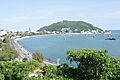
Front Beach skyline
-
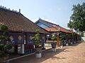
Long Sơn Mansion
-
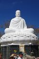
Thích Ca Phật Đài
-
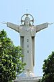
Christ of Vũng Tàu
-
Bạch Dinh
See also
 In Spanish: Vũng Tàu para niños
