
Lightning facts for kids
- For the NHL team, see Tampa Bay Lightning
- For the World War II fighter, see P-38 Lightning

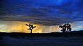
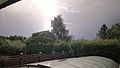
Lightning is a super powerful burst of electricity that happens during a thunderstorm. This electric blast is incredibly hot. It makes the air around it expand super fast, which then creates the loud sound we call thunder. Sometimes lightning flashes between clouds. Other times, it shoots from a cloud down to the ground. If lightning hits the ground, it can strike people or objects. About 50 to 100 lightning bolts hit Earth every single second. The Empire State Building has been struck by lightning as many as 500 times in one year!
Contents
How Lightning Was Discovered

Benjamin Franklin was very curious about lightning. He learned many things about it. In 1772, he was the first to show that a thunderstorm actually lets out electricity. In his book, he suggested an experiment to test this idea. Franklin didn't really fly a kite in a thunderstorm himself to prove electricity was there. Doing that could have been very dangerous, even deadly. However, it is possible to conduct electricity through a kite string safely.
How Thunderstorms Get Charged

Scientists are still studying exactly how thunderstorms get charged. But they agree on some main ideas. The most important charging area in a thunderstorm is in its middle part. Here, air moves quickly upwards, and temperatures are very cold, between -15 to -25 degrees Celsius.
In this cold, rising air, you find tiny water droplets that are super-cooled (meaning they are still liquid below freezing). You also find small ice crystals and graupel (which is like soft hail). The rising air carries the super-cooled water droplets and small ice crystals upwards. Meanwhile, the graupel is much bigger and heavier. It tends to fall or stay suspended in the rising air.

Because these different particles move differently, they crash into each other. When the rising ice crystals hit the graupel, the ice crystals get a positive charge. The graupel gets a negative charge. The rising air then carries the positively charged ice crystals higher up, towards the top of the storm cloud. The bigger, heavier graupel stays in the middle or falls to the lower part of the storm.

As a result, the top of the thunderstorm cloud becomes positively charged. The middle and lower parts of the cloud become negatively charged. The rising air and winds high up in the sky cause the small ice crystals (and their positive charge) to spread out. This happens horizontally, forming the wide, flat top of the thunderstorm cloud, called the anvil.
Different Kinds of Lightning
There are three main kinds of lightning. They are named based on where the lightning flash starts and ends.
- Intracloud (IC) lightning happens entirely inside one thundercloud.
- Cloud to cloud (CC) or intercloud lightning happens between two different thunderclouds.
- Cloud to ground (CG) lightning starts in a thundercloud and ends on the Earth's surface. It can also go the other way, from the ground to the cloud.
Cloud to Ground Lightning

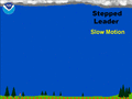
Cloud-to-ground (CG) lightning is a lightning bolt that goes from a thundercloud to the ground. It starts with a "stepped leader" moving down from the cloud. Then, a "streamer" moves up from the ground to meet it.
CG lightning is the least common type, but it's the one we understand best. This is because it hits a physical object (the Earth). This makes it easier for scientists to study with instruments on the ground. Of all the lightning types, CG lightning is the most dangerous. It can cause harm to people and property because it "strikes" the Earth.
Positive and Negative Lightning
Cloud-to-ground (CG) lightning can be either positive or negative. This depends on the direction the electric current flows from the cloud to the ground. Most CG lightning is negative. This means a negative charge moves to the ground, and electrons travel downwards.
In a positive CG flash, the opposite happens. Electrons travel upwards, and a positive charge moves to the ground. Positive lightning is less common than negative lightning. It makes up less than 5% of all lightning strikes.

Positive lightning strikes are usually much stronger than negative ones. An average negative lightning bolt carries about 30,000 amperes of electric current. It transfers 15 coulombs of electric charge and 500 megajoules of energy. Large negative bolts can carry up to 120,000 amperes.
The average positive ground flash has about double the peak current of a typical negative flash. It can produce peak currents up to 400,000 amperes. Because they are so much more powerful, positive lightning strikes are more dangerous. They can heat surfaces to very high temperatures, which increases the chance of fires starting.
Positive lightning can also cause "upward lightning" from tall buildings. It is also responsible for creating sprites. These are flashes of light that happen high above the ground. Positive lightning happens more often in winter storms, like during thundersnow. It also occurs during strong tornadoes and when a thunderstorm is fading away.
Sometimes, lightning appears to come from a clear sky far away from a storm. These are called "bolts from the blue." Even though they seem to come from a positive charge area, they are usually negative flashes. They start inside the cloud, then the negative part of the lightning leaves the cloud and strikes the ground far away.
Cloud to Cloud and Intra-Cloud Lightning


Lightning flashes can happen between different parts of clouds without hitting the ground. When it's between two separate clouds, it's called inter-cloud lightning. When it's between different charged areas within the same cloud, it's called intra-cloud lightning. Intra-cloud lightning is the most common type of lightning.
Intra-cloud lightning usually happens between the top (anvil) part and the lower parts of a thunderstorm. You can sometimes see this lightning from far away at night. It looks like a general flash of light across the sky, often called "sheet lightning". When you see sheet lightning, you usually don't hear any thunder because it's too far away.

Another name for cloud-to-cloud lightning is "Anvil Crawler." This is because the lightning seems to crawl through the upper cloud layers of a thunderstorm's anvil. These flashes often create amazing, branching patterns across the sky. You usually see them as a thunderstorm moves over you or starts to break apart.
Other Kinds of Lightning
- Ball lightning is a mysterious electrical event. People report seeing glowing, round objects that can be pea-sized to several meters wide. It's sometimes seen during thunderstorms. Unlike regular lightning, which lasts only a fraction of a second, ball lightning can last for many seconds. Scientists don't fully understand it yet.
- Dry lightning happens when lightning strikes but there's no rain at the ground. This type of lightning is the most common natural cause of wildfires.
- Forked lightning is cloud-to-ground lightning that has many visible branches, like the branches of a tree.
- Heat lightning is lightning that you can see but can't hear any thunder. This happens because the lightning is too far away for the sound waves to reach you. The sound simply fades away before it gets to your ears.
- Ribbon lightning happens in storms with strong winds. The wind blows each lightning stroke slightly to the side of the one before it. This creates a cool "ribbon" effect.
- Sheet lightning is cloud-to-cloud lightning that makes a cloud glow brightly. You can't see the actual lightning bolt, just the bright flash across the cloud. This happens when the lightning path is hidden or too far away.
- Superbolts are lightning bolts that are about a hundred times brighter than normal. Only about one in a million lightning strikes on Earth is a superbolt.
What Happens When Lightning Strikes
Lightning Strike Effects

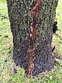
When lightning strikes an object, it creates huge amounts of heat and magnetic force. If lightning hits a tree, the heat can turn the tree's sap into steam. This causes a steam explosion that can burst the tree's trunk. If lightning strikes sandy soil, the sand around the lightning channel can melt. This forms tube-like structures called fulgurites.
About 90% of people struck by lightning survive. However, humans or animals hit by lightning can suffer serious injuries. This is because lightning can damage internal organs and the nervous system. Buildings or tall structures hit by lightning can also be damaged. This happens if the lightning finds unintended paths to the ground.
A lightning protection system can help. It safely guides a lightning strike to the ground. This greatly reduces the chance of serious property damage. Lightning also plays an important role in the nitrogen cycle. It changes nitrogen gas in the air into nitrates. Rain then carries these nitrates to the ground, which helps plants grow.
Thunder

When lightning flashes, it heats the air around its path to super-hot temperatures. This hot air expands very quickly, creating a powerful shock wave. This shock wave is what we hear as thunder. Since the sound comes from the entire path of the lightning, not just one spot, it can create a rolling or rumbling sound. The sound also bounces off terrain, making it even more complex.
Light travels extremely fast, about 300,000,000 meters per second. Sound travels much slower, about 343 meters per second through air. You can figure out how far away a lightning strike is by counting the seconds between seeing the flash and hearing the thunder.
If you see lightning and hear thunder one second later, the lightning was about 343 meters away. If there's a three-second delay, it's about 1 kilometer away. A five-second delay means the lightning was about 1 mile away. So, if lightning strikes very close, you'll hear a sudden, loud clap of thunder almost instantly. You might even smell ozone (a sharp, clean smell).
Sometimes, you can see lightning from far away but not hear the thunder. This is because sound waves don't travel as far as light. A lightning storm can be seen from over 100 miles away, but the thunder usually only travels about 20 miles.
Making Lightning
A Tesla coil is a device that people can use to create small lightning bolts. This helps them study electricity in a controlled way.
Images for kids
-
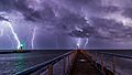
Strokes of cloud-to-ground lightning strike the ocean off of Port-la-Nouvelle in southern France.
-
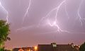
Lightning in Belfort, France
-
The 477 mile megaflash from Texas to Louisiana.
-
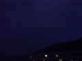
View of lightning from an airplane flying above a system.
-
An intra-cloud flash. A lightning flash within the cloud illuminates the entire cloud.
-
A downward leader travels towards earth, branching as it goes.
-
Lightning strike caused by the connection of two leaders, positive shown in blue and negative in red
-
Upwards streamer emanating from the top of a pool cover
-
High-speed photography showing different parts of a lightning flash during the discharge process as seen in Toulouse, France.
-
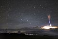
Gigantic jet as seen from the summit of Mauna Kea, Hawaii.
-
Explosive steam pressure between trunk and bark from lightning strike blew away birch bark
-
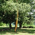
Strike mark on trunk of an Oklahoma black walnut
-
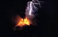
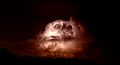
Volcanic material thrust high into the atmosphere can trigger lightning.
-
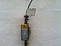
Lightning strike counter in a museum
-
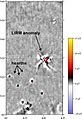
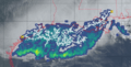
Lightning-induced remanent magnetization (LIRM) mapped during a magnetic field gradient survey of an archaeological site located in Wyoming, United States.
-
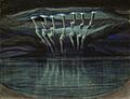
Lightning by Mikalojus Konstantinas Ciurlionis (1909)
-
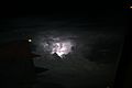
Intra-clouds lightning over the Baltic Sea.


.jpg)


See also
 In Spanish: Rayo para niños
