Thundersnow facts for kids

Thundersnow is a special kind of thunderstorm where snow falls instead of rain. It's also called a winter thunderstorm or a thundersnow storm. This weather event is quite rare.
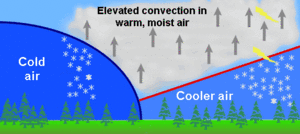
Normally, thunderstorms happen when warm, moist air rises. Thundersnow is similar, but it happens in very cold air. The clouds that cause thundersnow, called cumulonimbus clouds, are usually lower than regular storm clouds. Besides snow, you might also see graupel (soft, icy pellets) or even hail.
One cool thing about thundersnow is how the sound changes. The heavy snow falling makes the thunder sound muffled. It's more like a low rumble than the loud, sharp crack you hear during a summer storm.
Thundersnow can happen in a few ways. Sometimes, it's just a regular snowstorm with strong winds mixing the air. This creates the right conditions for lightning and thunder. It can also happen near large bodies of water, like the Great Lakes. This is called the "lake effect" or "ocean effect." Cold air moving over warmer water can create snow squalls and even thundersnow.
Contents
Where Does Thundersnow Happen?
Thundersnow can occur in many parts of the world, but it's still quite unusual.
Thundersnow in the Americas
In the United States, thundersnow is rare. It's most common in places like eastern Nevada and Utah. It also happens in the Great Plains and near the Great Lakes. The Northeastern United States, especially New England and New York, sometimes sees thundersnow several times each winter. For example, in December 2019, parts of Massachusetts had a storm with lightning, thundersnow, and even thunder-sleet. A very rare thundersnow storm also hit near Vancouver, British Columbia, in December 2022.
In South America, the South Region of Brazil has had thundersnow. This happened in 1984 and 2005 in Santa Catarina. In August 2011, some towns in the highlands of Rio Grande do Sul also saw thundersnow.
Thundersnow in Europe
The British Isles and other parts of northwestern Europe sometimes report thunder and lightning during sleet or snow. This usually happens in winter and spring. Scotland had thundersnow in December 2020, which surprised many people. The Met Office (UK's weather service) even warned about thundersnow in Scotland, Wales, and northern England in January 2022.
Western Europe rarely sees thundersnow. But on March 8, 2010, northeastern Catalonia, including Barcelona, had heavy snow with lightning. Snow was over 30 centimetres (12 in) deep in some low areas.
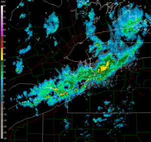
In Central Europe, a big thundersnow event happened on January 17, 2022. A strong line of storms moved across Poland, bringing snow and many lightning strikes. Other recent events include Poland and the Czech Republic in January 2023, Germany in January 2021, and Norway, Netherlands, and Austria in April 2021. Stockholm in Sweden also had thundersnow in November 2022.
Thundersnow in Asia
In the eastern Mediterranean, storms from the polar regions often bring a lot of thundersnow. This is especially true in the higher areas of Israel and Jordan, like Amman and Jerusalem. When these storms hit skiing areas, mountains are often cleared for safety.
Thundersnow is also common around Kanazawa and the Sea of Japan. It can even happen near Mount Everest.
How Thundersnow Forms
Thundersnow forms in a similar way to regular thunderstorms. However, it's much rarer because cold, heavy air doesn't usually rise easily.
Lake Effect Thundersnow
Lake effect thundersnow happens when very cold air moves over a warmer lake or ocean. This makes the air above the water unstable and causes it to rise quickly. If the lake temperature is much warmer (about 25 °C (45 °F) or more) than the air high up (around 1,500 m (4,900 ft)), thundersnow can start. This is especially true if the ground temperature is freezing.
Several things help lake effect thundersnow form:
- Cloud Height: The clouds need to be tall enough. Air must rise at least 1,500 m (4,900 ft), and usually 3,000 m (9,800 ft) or more, for thundersnow to happen.
- Wind Conditions: Winds need to be fairly steady. If the wind changes direction too much, it can break apart the snow squall.
- Moisture: The cold air needs to travel a certain distance (at least 50 km/h (31 mph) of "fetch") over the water. This allows it to pick up enough moisture and warmth from the lake or ocean.
- Cloud Temperature: The very top of the storm cloud must be at least −30 °C (−22 °F). At this temperature, the cloud is mostly ice crystals. When these ice crystals and graupel pellets rub together, they create an electrical charge. This leads to lightning and thunder.
Storm System Thundersnow
Large snowstorms, often called "synoptic snow storms," can also produce thundersnow. This often happens in a specific part of a big storm system, usually in the northwest section of a mature extratropical cyclone. Thundersnow can also form under a "TROWAL" (trough of warm air aloft). This is a band of warmer air that extends into the cold part of the storm. In some extreme cases, thunderstorms that usually bring rain can move into very cold areas of a storm. Their rain then turns into snow or ice, causing thundersnow. Famous blizzards like the 1991 Halloween blizzard and the Superstorm of 1993 had thundersnow.
Mountain Thundersnow
Similar to lake effect thundersnow, thundersnow can also happen in mountainous areas. This occurs when a wave of unstable air moves into a region where it's very cold. The rising air over the mountains can lead to heavy snow and sometimes thundersnow.
What Are the Dangers of Thundersnow?
Thundersnow can bring very heavy snowfall, often 5 to 10 cm (2 to 4 in) per hour. This much snow can quickly make it hard to see, even without strong winds.
However, thundersnow often happens during severe winter storms or blizzards. This means strong winds are common. Winds can be as strong as a tropical storm. These strong winds, combined with heavy snow, can reduce visibility to almost nothing (under 2/5ths of a mile).
Strong winds also create extremely low wind chills, which can quickly lead to frostbite.
Finally, the lightning in a thundersnow storm is often "positive lightning." This type of lightning can be more powerful and destructive than the more common negative lightning. However, lightning is much less frequent in a thundersnow storm than in a summer thunderstorm. It usually stays within the clouds rather than striking the ground.
See also
- Blizzard warning
- Severe thunderstorm warning
- Severe weather terminology (United States)


