Gresham, Oregon facts for kids
Quick facts for kids
Gresham
|
|||
|---|---|---|---|
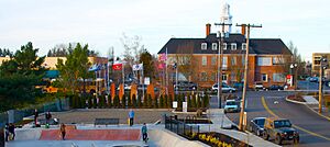
Downtown Gresham from City Park
|
|||
|
|||
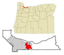
Location in Multnomah County, Oregon
|
|||
| Country | United States | ||
| State | Oregon | ||
| County | Multnomah | ||
| Settled | 1851 | ||
| Incorporated | 1905 | ||
| Named for | Walter Q. Gresham | ||
| Government | |||
| • Type | Council–manager | ||
| Area | |||
| • City | 23.65 sq mi (61.26 km2) | ||
| • Land | 23.52 sq mi (60.91 km2) | ||
| • Water | 0.13 sq mi (0.35 km2) | ||
| Elevation | 384 ft (117 m) | ||
| Population
(2020)
|
|||
| • City | 114,247 | ||
| • Estimate
(2022)
|
111,621 | ||
| • Rank | US: 273rd OR: 4th |
||
| • Density | 4,857.65/sq mi (1,875.55/km2) | ||
| • Urban | 2,104,238 (US: 23rd) | ||
| • Metro | 2,509,489 (US: 25th) | ||
| Time zone | UTC–8 (Pacific (PST)) | ||
| • Summer (DST) | UTC–7 (PDT) | ||
| ZIP codes |
97030, 97080, 97233
|
||
| Area code(s) | 503 and 971 | ||
| FIPS code | 41-31250 | ||
| GNIS feature ID | 2410663 | ||
Gresham is a city in Oregon, a state in the United States. It is located in Multnomah County, right next to Portland.
The city was first settled in the early 1850s by the Powell brothers. It became an official city in 1905. Gresham was named after Walter Quintin Gresham, who was a general in the American Civil War and later a United States Secretary of State.
In the beginning, farming was the main way people made a living here. By the mid-1900s, Gresham grew a lot. Its population jumped from 4,000 to over 10,000 people between 1960 and 1970. In 2020, about 114,247 people lived in Gresham. This makes it the fourth-largest city in Oregon. Gresham is an important business hub for the eastern part of Multnomah County.
Contents
History of Gresham
The area we now call Gresham was first settled in 1851. Two brothers, Jackson and James Powell, claimed land there. They named their settlement Powell's Valley.
In 1884, a local store owner asked for a post office. He suggested naming it after Walter Q. Gresham, who was the Postmaster General at the time. This request was approved.
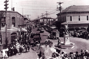
Gresham officially became a city in 1905. At that time, only 365 people lived there. Lewis Shattuck was the first mayor. Farming was very important, especially growing berries, grapes, and vegetables. Trains ran regularly between Gresham and Portland. Many early settlers from Gresham also helped start nearby towns like Boring and Sandy.
Gresham's city library started as a small collection of books in a general store. In 1913, it became an official public library. This happened with help from a grant by Andrew Carnegie, who funded many libraries.
Gresham General Hospital opened in 1959. It later moved and became Mount Hood Medical Center in 1984.
Geography of Gresham
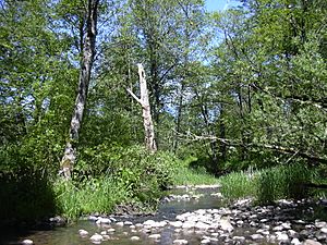
Gresham covers about 23.43 square miles (60.68 square kilometers). Most of this area is land, with a small part being water. The city includes parts of Fairview Creek and Johnson Creek.
The eastern and northeastern parts of Gresham have hills. The city's elevation is about 325 feet (99 meters) above sea level. Johnson Creek flows through Gresham. About 23% of the creek's path is within the city.
Neighborhoods in Gresham
Gresham has 16 official neighborhoods. Some of these include Central City, Centennial, Hogan Cedars, Hollybrook, Kelly Creek, and Rockwood.
Climate in Gresham
Gresham has a Mediterranean climate. This means summers are usually warm and sunny with little rain. Winters are cloudy, cool, and often rainy.
| Climate data for Gresham, OR | |||||||||||||
|---|---|---|---|---|---|---|---|---|---|---|---|---|---|
| Month | Jan | Feb | Mar | Apr | May | Jun | Jul | Aug | Sep | Oct | Nov | Dec | Year |
| Mean daily maximum °F (°C) | 46 (8) |
51 (11) |
56 (13) |
62 (17) |
69 (21) |
75 (24) |
82 (28) |
82 (28) |
77 (25) |
65 (18) |
53 (12) |
46 (8) |
64 (18) |
| Mean daily minimum °F (°C) | 35 (2) |
36 (2) |
38 (3) |
41 (5) |
47 (8) |
51 (11) |
55 (13) |
55 (13) |
51 (11) |
44 (7) |
39 (4) |
35 (2) |
44 (7) |
| Average precipitation inches (mm) | 6.77 (172) |
5.16 (131) |
4.70 (119) |
3.95 (100) |
2.93 (74) |
2.26 (57) |
0.54 (14) |
0.69 (18) |
1.90 (48) |
4.34 (110) |
6.93 (176) |
7.61 (193) |
47.78 (1,212) |
| Average snowfall inches (cm) | 1.5 (3.9) |
1.7 (4.3) |
1.7 (4.4) |
0 (0) |
0 (0) |
0 (0) |
0 (0) |
0 (0) |
0 (0) |
0 (0) |
0.2 (0.6) |
0.7 (1.7) |
5.8 (14.9) |
| Average rainy days | 18.1 | 16.1 | 19.3 | 17.6 | 13.5 | 10.9 | 4.9 | 4.4 | 9.7 | 15 | 18.5 | 17.6 | 165.6 |
| Average snowy days | 1.5 | 2.8 | 1.7 | 0.3 | 0 | 0 | 0 | 0 | 0 | 0 | 0.7 | 1.2 | 8.2 |
| Average relative humidity (%) | 82 | 84 | 81 | 78 | 73 | 71 | 65 | 64 | 69 | 75 | 81 | 82 | 75 |
| Source 1: weather.com | |||||||||||||
| Source 2: weather atlas(snow - precipitation days-humidity) | |||||||||||||
Population of Gresham
| Historical population | |||
|---|---|---|---|
| Census | Pop. | %± | |
| 1910 | 510 | — | |
| 1920 | 1,103 | 116.3% | |
| 1930 | 1,635 | 48.2% | |
| 1940 | 1,951 | 19.3% | |
| 1950 | 3,049 | 56.3% | |
| 1960 | 3,944 | 29.4% | |
| 1970 | 10,030 | 154.3% | |
| 1980 | 33,005 | 229.1% | |
| 1990 | 68,235 | 106.7% | |
| 2000 | 90,205 | 32.2% | |
| 2010 | 105,594 | 17.1% | |
| 2020 | 114,247 | 8.2% | |
| 2022 (est.) | 111,621 | 5.7% | |
| U.S. Decennial Census 2020 Census |
|||
Gresham's Population in 2020
In 2020, the city of Gresham had 114,247 people living in 44,816 households.
| Race / Ethnicity (NH = Non-Hispanic) | Pop 2000 | Pop 2010 | Pop 2020 | % 2000 | % 2010 | % 2020 |
|---|---|---|---|---|---|---|
| White alone (NH) | 71,194 | 72,549 | 68,097 | 78.92% | 68.71% | 59.61% |
| Black or African American alone (NH) | 1,618 | 3,530 | 5,665 | 1.79% | 3.34% | 4.96% |
| Native American or Alaska Native alone (NH) | 704 | 808 | 878 | 0.78% | 0.77% | 0.77% |
| Asian alone (NH) | 2,969 | 4,446 | 6,791 | 3.29% | 4.21% | 5.94% |
| Pacific Islander alone (NH) | 217 | 698 | 1,213 | 0.24% | 0.66% | 1.06% |
| Other race alone (NH) | 99 | 148 | 559 | 0.11% | 0.14% | 0.49% |
| Mixed Race or Multi-Racial (NH) | 2,672 | 3,431 | 7,001 | 2.96% | 3.25% | 6.13% |
| Hispanic or Latino (any race) | 10,732 | 19,984 | 24,043 | 11.90% | 18.93% | 21.04% |
| Total | 90,205 | 105,594 | 114,247 | 100.00% | 100.00% | 100.00% |
Gresham's Population in 2010
In 2010, Gresham had 105,594 people living in 38,704 households. About 36.9% of households had children under 18. The average household had 2.69 people.
The average age of people in Gresham was 33.6 years. About 26.4% of residents were under 18.
Historic Sites and Culture
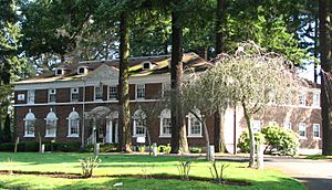
Gresham has several places listed on the National Register of Historic Places. These are buildings and sites important to history.
Some examples include:
- The Louise Home Hospital and Residence Hall, a social services building.
- The Jacob Zimmerman House, a farmhouse built in 1874.
- The Hamlin–Johnson House, another farmhouse from 1888.
- The Emanuel and Christina Anderson House and William Gedamke House, both beautiful Victorian homes from around 1900.
- The Gresham Carnegie Library, built in 1913.
Parks and Outdoor Fun
Gresham has many parks for outdoor activities. Main City Park is a popular spot near downtown. Other parks include Hogan Butte Nature Park, East Gresham Park, and Red Sunset Park.
You can also visit Persimmon Country Club or Gresham Golf Course. The Gresham Pioneer Cemetery, founded in 1859, is another interesting public place.
Trails for Biking and Walking
Gresham offers several trails perfect for biking and walking:
- Springwater Corridor
- 40-Mile Loop
- Gresham–Fairview Trail
- Gresham Butte Saddle Trail
- Kelly Creek Greenway Trail
- Nadaka Loop Trail
Education in Gresham
Gresham is served by three school districts: Centennial, Gresham-Barlow, and Reynolds.
High schools in the area include Gresham High School, Sam Barlow High School, and Centennial High School. There are also private schools like Portland Adventist Elementary School.
Mount Hood Community College is located in Gresham. It offers two-year degrees and also has programs where students can earn a four-year bachelor's degree through a partnership with Eastern Oregon University. Many Gresham residents have college degrees.
Transportation in Gresham
Highways
You can reach Gresham from the west using Interstate 84. From the east, you can use U.S. Route 26.
Public Transportation
Gresham has a public transportation system called TriMet. This includes bus routes and the MAX Light Rail Blue Line.
The MAX Blue Line has several stations in Gresham:
- East 162nd Avenue
- East 172nd Avenue
- East 181st Avenue
- Rockwood/East 188th Avenue (serving the Rockwood neighborhood)
- Ruby Junction/East 197th Avenue
- Civic Drive
- Gresham City Hall
- Gresham Central Transit Center
- Cleveland Avenue (this is where the Blue Line ends in the east)
There's also a free shuttle bus called Sandy Area Metro that connects Gresham to Sandy, Oregon.
Famous People from Gresham
Many notable people have connections to Gresham:
- Shannon Bex (b. 1980), a singer from the group Danity Kane.
- Brian Burres (b. 1981), a Major League Baseball pitcher.
- Randy Couture (b. 1963), a famous mixed martial arts fighter.
- Sam Crouser (b. 1991), an Olympic athlete.
- Marco Farfan, a professional soccer player.
- Nikki Fuller (b. 1968), a professional female bodybuilder.
- Robert Garrigus (b. 1977), a PGA Tour golfer.
- Katie Harman (b. 1980), Miss America 2002.
- Jess Hartley (b. 1967), an author and game designer.
- Fred Jones (b. 1979), a National Basketball Association player.
- Fouad Kaady (1978–2005), a former resident.
- Robert S. Lucas, a U.S. Coast Guard Rear Admiral.
- Ronald A. Marks, a former CIA official.
- Khamphoui Sisavatdy, a former prime minister of the Royal Lao Government in Exile.
- Stu Weber, a Christian author.
Sister Cities
Gresham has "sister cities" around the world, which means they have special friendly relationships:
See also
 In Spanish: Gresham (Oregón) para niños
 | Janet Taylor Pickett |
 | Synthia Saint James |
 | Howardena Pindell |
 | Faith Ringgold |


