
Springwater Corridor facts for kids
The Springwater Corridor Trail is a special path in the Portland area of Oregon, USA. It's designed for people to ride bikes and walk. This trail follows an old railway line that used to run from a town called Boring through Gresham all the way to Portland. In Portland, it ends near the Eastbank Esplanade.
Most of the trail, which is about 21 miles (34 km) long, is a paved path away from busy streets. However, about 1 mile (1.6 km) of it goes along city streets in Portland's Sellwood neighborhood. A big part of the trail runs close to Johnson Creek and crosses it many times using bridges. The City of Portland bought most of this land in 1990, and the rest was bought by Metro later.
The Springwater Corridor Trail is an important part of Portland's bigger 40-Mile Loop trail system. It connects to many parks nearby, like Tideman Johnson Natural Area and Powell Butte.
Trail History
The Springwater Division rail line got its name because it was planned to connect to a place called Springwater, Oregon.
The Portland Traction Company ran trains on this line from Portland to Boring. This started in 1903 and ended in 1989. The most people rode these trains in 1906, but passenger service stopped completely in 1958. Fun places like Oaks Amusement Park were even built to encourage people to ride the trains on weekends! Freight trains also used the line to bring farm products into Portland.
Around 1989, the Oregon Department of Transportation (ODOT) wanted to make Oregon Highway 99E wider. This meant they would need to build a new, expensive bridge for the train line to go over the highway. But because not many trains were using the line anymore, the railroad companies decided not to build the bridge and instead put the land up for sale.
This was exciting news for the 40-Mile Loop Trust. This group was formed in 1981 to create a trail that would go all around Portland, connecting its many parks. They had been planning this since 1904 but hadn't made much progress. The Trust worked hard to get different government groups to cooperate. They talked to the Southern Pacific and Union Pacific railroads, who owned the old line, to ask them to give the land for the trail. After some discussions, the deal was finished by 1990. This was a huge step forward for completing the 40-Mile Loop.
When they were planning how to change the old rail line into a trail in 1991, they thought about 400,000 people would use it each year. They expected that 56% would be biking, 36% walking, 9% jogging, and 3% riding horses. By 2003, they thought more than a million people would use the trail every year! Before the trail was paved, it was a great place for mountain biking.
The part of the trail that runs east-west between Oregon Highway 99E and Gresham was finished in 1996. Another mile east of Gresham was added in 2000. In 2005, a 3-mile (4.8 km) section called "Springwater on the Willamette" opened. This part runs north-south between central Portland and the Sellwood Bridge along the Willamette River. Unlike other parts of the trail, this section still has train tracks next to it, separated by a fence. The Oregon Pacific Railroad still uses these tracks.
The last big part of the trail was finished earlier than planned in the summer of 2006. This involved building three new bridges over Johnson Creek, Oregon Highway 99E, and another railroad line. These bridges made it possible for people to use the trail without having to go onto busy streets.
In 2012, there was still a 1-mile (1.6 km) gap in the trail in the Sellwood area. But there were plans to close this gap. This section was suggested for funding by a Metro group in 2001.
In 2013, the trail was paved for a 2.25-mile (3.62 km) stretch from Rugg Road to Boring Station Trailhead Park. There's also an idea to continue this trail even further to connect the 40-Mile Loop to the famous Pacific Crest Trail using the Cazadero Trail.
Trail Locations
| Location | Coordinates | Trail location | Elevation | ||
|---|---|---|---|---|---|
| mi | km | ft | m | ||
| S.E. Fourth Ave. and S.E. Ivon St. trailhead | 45°30′13.90″N 122°39′42.79″W / 45.5038611°N 122.6618861°W | 0.0 | 0 | 51 | 16 |
| S.E. Umatilla St. (temporary trail end) | 45°27′46.69″N 122°39′38.21″W / 45.4629694°N 122.6606139°W | 3.1 | 5.0 | 70 | 21 |
| S.E. 19th Ave. and Ochoco St. (trail resumes) | 45°27′31.49″N 122°38′41.81″W / 45.4587472°N 122.6449472°W | 4.2 | 6.8 | 73 | 22 |
| Tideman Johnson Natural Area | 45°27′47.69″N 122°37′26.12″W / 45.4632472°N 122.6239222°W | 5.1 | 8.2 | 103 | 31 |
| Interstate 205 | 45°28′20.23″N 122°33′58.25″W / 45.4722861°N 122.5661806°W | 8.7 | 14.0 | 206 | 63 |
| Linneman Station | 45°29′14.26″N 122°28′31.19″W / 45.4872944°N 122.4753306°W | 13.4 | 21.6 | 266 | 81 |
| S.E. 267th Ave. and S.E. Rugg Rd. trail access | 45°27′37.34″N 122°23′17.73″W / 45.4603722°N 122.3882583°W | 18.9 | 30.4 | 427 | 130 |
| Boring (paved in 2013) | 45°25′54.70″N 122°22′31.19″W / 45.4318611°N 122.3753306°W | 21 | 34 | 517 | 158 |
Images for kids
-
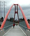
The Springwater Trail crosses over McLoughlin Boulevard (Oregon Route 99E) near Portland's Sellwood neighborhood.
-
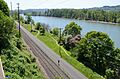
The trail's easternmost section, a north–south segment in Portland, runs near the east bank of the Willamette River and alongside a still-in-use Oregon Pacific Railroad track.
-
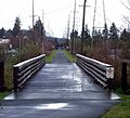
This straight portion parallels Johnson Creek Boulevard and crosses many intersecting streets.
-
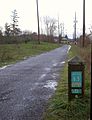
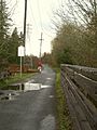
Most of the trail is bordered by fields and trees.
-
Corridor adjacent to Tideman Johnson Natural Area


