Powell Butte facts for kids
Quick facts for kids Powell Butte |
|
|---|---|

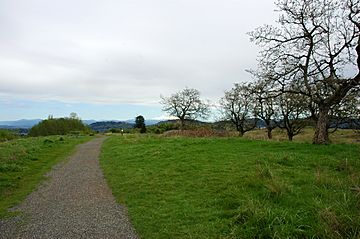
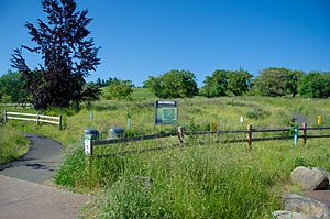
The Powell Butte Nature Park, located on the butte's summit
|
|
| Highest point | |
| Elevation | 614 ft (187 m) NAVD 88 |
| Geography | |
| Location | Multnomah County, Oregon, U.S. |
| Parent range | Cascades |
| Topo map | USGS Gladstone |
| Geology | |
| Mountain type | Cinder cone |
| Volcanic field | Boring Lava Field |
| Last eruption | Extinct |
Powell Butte is an extinct volcano in Portland, Oregon, United States. It's a type of volcano called a cinder cone, which looks like a cone-shaped hill.
Powell Butte is part of the Boring Lava Field. This area has over 80 small volcanoes and lava flows around Portland and Vancouver. The climate around Powell Butte is cool. You can find meadows, rivers, and forests there.
Today, Powell Butte is home to the Powell Butte Nature Park. This park has trails for biking, hiking, and horseback riding. It covers about 612 acres (2.48 square kilometers).
Long ago, the land around Powell Butte belonged to the Confederated Tribes of the Grand Ronde Community of Oregon. Now, two large underground tanks at the butte hold fresh water. These tanks are a main part of Portland's public water system.
What is Powell Butte?
Powell Butte is located in Multnomah County, Oregon. It's a cinder cone volcano. This means it's a cone-shaped hill made from volcanic ash and rock pieces.
The butte is part of the Boring Lava Field. This field is a group of small volcanoes that look like hills. They are named after the Boring Hills. These volcanoes are found throughout the Portland–Vancouver area. They can be as tall as 650 feet (198 meters) above the land around them.
There are more than 80 small volcanoes and lava flows in this field. Some might even be hidden under layers of dirt and rock. The volcanoes in the Boring Lava Field formed because one tectonic plate (the Juan de Fuca Plate) is sliding under another (the North American Plate).
Powell Butte is an extinct volcano. This means it is no longer active and won't erupt again. Other nearby volcanoes include Green Mountain, Prune Hill, and Mount Tabor.
Climate and Nature
The weather at Powell Butte is cool. This means plants have a short time to grow each year. You can see grassy meadows there. These meadows support apple, pear, and walnut trees.
Powell Butte is close to Johnson Creek. This creek flows into the Willamette River. It's home to native salmon and rainbow trout.
The Powell Butte Nature Park has many animals. You might see bats, black-tailed mule deer, chipmunks, coyotes, gray foxes, ground squirrels, rabbits, raccoons, ring-necked pheasants, and skunks.
Many birds of prey fly over the park's open meadows. You can also find groves of wild hawthorn and western red cedar trees. Kestrels and red-tailed hawks hunt for food on top of the butte. On the northern side of the butte, there are forests of bigleaf maple and Douglas fir trees.
History of Powell Butte
Powell Butte is on land that was historically used by the Confederated Tribes of the Grand Ronde Community of Oregon. Their territory was huge, covering over 20 million acres (80,937 square kilometers).
In the late 1800s, settlers cleared much of the meadow area near Powell Butte. They planted an orchard there. In 1925, the city of Portland bought the land. They planned to use it for water reservoirs.
The city leased part of the land to a farmer named Henry Anderegg. He ran the Meadowland Crest Dairy until 1948. In the 1970s, Portland's Water Bureau planned to build four large underground water tanks at the butte. Each tank would hold 50 million US gallons (189 million liters) of water. The first tank was built in 1981, and the second in 2014.
From 1986 to 2018, Powell Butte was also a research farm for Oregon State University. They grew potatoes there to develop new types. In 2010, a potato disease caused the farm to close down. The land was later sold to a company that grows hemp.
Fun at Powell Butte
Powell Butte is a popular spot for outdoor fun. The Powell Butte Nature Park opened to the public in 1990. It is managed by Portland Parks & Recreation.
The park has about 9 miles (14 kilometers) of trails. You can go biking, horseback riding, or hiking on these paths. There are many official and unofficial trails to explore.
From the top of Powell Butte, you can see amazing views. On a clear day, you might spot Mount Adams, Mount Hood, Mount Jefferson, and Mount St. Helens.
The Friends of Powell Butte is a group that helps protect the nature park. They work to keep the park beautiful and gather ideas from visitors.
 | Ernest Everett Just |
 | Mary Jackson |
 | Emmett Chappelle |
 | Marie Maynard Daly |


