Mount Tabor (Oregon) facts for kids
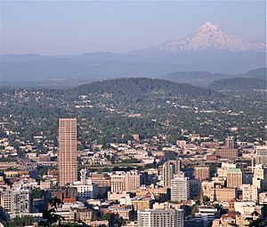
Mount Tabor is a special place in Southeast Portland, Oregon. It's actually an extinct volcano! The name "Mount Tabor" also refers to the city park on top of the volcano and the area around it. It was named after Mount Tabor in Israel by Plympton Kelly, whose father was an early settler in Oregon City.
What is a Cinder Cone?
Quick facts for kids |
|
|
Mount Tabor Park
|
|
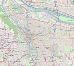
| Location | Roughly bounded by SE Division Street, SE 60th Avenue, SE Yamhill Street, and SE Mountainview Drive, Portland, Oregon |
|---|---|
| Built | 1903 |
| Architect | Emanuel Tillman Mische, Charles P. Keyser |
| Architectural style | Late Victorian, Late 19th, and 20th Century Revivals |
| NRHP reference No. | 04001065 |
| Added to NRHP | September 22, 2004 |
Mount Tabor is a type of volcano called a cinder cone. It stands about 636 feet (194 meters) tall. The land around it is about 200 feet (61 meters) high, so the volcano itself rises quite a bit above the area.
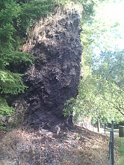
Near the top of Mount Tabor, where you can now find a basketball court and an outdoor theater, part of the cinder cone was cut away. You can still see the volcanic rock there! The leftover cinders were even used to pave the nearby parking lot.
Mount Tabor is part of a larger group of volcanoes called the Boring Lava Field. This field includes many small cinder cones and shield volcanoes that stretch from Boring, Oregon all the way to southwest Washington. These volcanoes stopped erupting over 300,000 years ago. Other cinder cones from this field that are also in Portland include Rocky Butte, Powell Butte, and Kelly Butte.
Portland is one of only a few cities in the United States that has an extinct volcano right inside its city limits. Other cities with volcanoes inside them include Bend (with Pilot Butte), Jackson, Honolulu (with Diamond Head), Prescott Valley, Arizona, and Austin. People didn't even know Mount Tabor was a volcano until 1913, when workers building a road found volcanic cinders in the park.
Mount Tabor Park
|
Mount Tabor Park Reservoirs
Historic District |
|
|
U.S. Historic district
Contributing property |
|

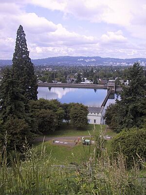
Reservoir #6 in 2006
|
|
| Location | 1900 SE Reservoir Loop Portland, Oregon |
|---|---|
| Area | 176.04 acres (71.24 ha) |
| Built | 1894 |
| Architect | Isaac Smith, et al. |
| Architectural style | Romanesque |
| Part of | Mount Tabor Park (ID04001065) |
| NRHP reference No. | 03001446 |
| Added to NRHP | January 15, 2004 |
In the 1880s, people realized that Mount Tabor would be a perfect spot for water reservoirs because it was so high up. This height was great for a water distribution system. The Mount Tabor reservoirs were built between 1894 and 1911. At the same time, reservoirs were also built in Washington Park.
City leaders decided to create a public water system. They piped water about 25 miles (40 kilometers) from the Bull Run River watershed to the Mount Tabor reservoirs. This water system started in 1894. The Bull Run watershed was one of the first federal lands to be protected for its natural resources.
The reservoirs and their gatehouses were built very carefully and look like works of art. They used strong concrete that was made to look like stone. There were four large reservoirs above ground (numbered 1, 2, 5, and 6). Reservoir 2 was later closed, and its land was sold, but its gatehouse is still there as a private home. Reservoir 6 is the biggest, holding 37 million gallons of water in each of its two sections. It also has a fountain that was turned back on in 2007. Three of these reservoirs were added to the National Register of Historic Places in 2004 because of their historical importance.
John Charles Olmsted, a famous landscape architect, visited Portland in 1903. He was asked to help design the site for a big event called the Lewis and Clark World Exposition. While he was in Portland, he toured the city and suggested that Mount Tabor should be saved for a future park, even though it was far from the city back then. Following his advice, the Portland Parks Bureau started buying land there in 1909. The park was designed by Emanuel Tillman Mische, a very skilled gardener and landscape designer. Mount Tabor Park, which is 196 acres (0.79 square kilometers), was Portland's largest park until Forest Park was created in 1947.
The park was never officially named "Mount Tabor Park" by the city. There was a plan to name it "Williams Park," but people in the neighborhood wanted to keep the historic name, Mount Tabor Park. The entire park, including its maintenance yard, was added to the National Register of Historic Places in 2004.
The park has a statue of Harvey W. Scott, who was a famous newspaper editor. This large statue was made by Gutzon Borglum, who also sculpted the faces on Mount Rushmore. The bronze statue was officially revealed on July 22, 1933, with about 3,000 people watching.
Getting to the Park
You can drive into Mount Tabor Park from several streets: 69th Avenue and Yamhill Street on the north, Harrison Street on the east, Lincoln Street on the southwest, and 60th Avenue and Salmon Street on the northwest. There's also a special area for dogs to run off-leash on the south side near the Harrison entrance. You can also walk into the park from many dead-end streets on the south side off 72nd Avenue.
Hiking Trails
Mount Tabor has many paths, and you can climb it from almost any direction. There are three official trails that start and end at a kiosk in the parking lot near the 69th and Yamhill entrance.
- The easy Red Trail is one mile (1.6 km) long.
- The Green Trail is a bit harder at 1.7 miles (2.7 km).
- The most challenging Blue Trail is 3 miles (4.8 km) long.
All these trails go around the volcano using gravel paths and paved roads. The Blue Trail includes a 96-step stairway between Reservoirs 5 and 6. It also has an extra 0.31-mile (0.5 km) loop around the very top of the volcano.
You can ride bicycles on the Red and Blue Trails. Dogs are allowed on all trails, but they must be on a leash. Restrooms are available at the top of the volcano and at the visitors' center near the 60th and Salmon entrance.
Visitors' Center
In October 2011, a group called the Friends of Mount Tabor Park opened a visitors' center. It's located in what used to be a storage room in the park.
 | Emma Amos |
 | Edward Mitchell Bannister |
 | Larry D. Alexander |
 | Ernie Barnes |


