Rocky Butte facts for kids
Quick facts for kids Rocky Butte |
|
|---|---|
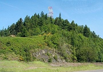
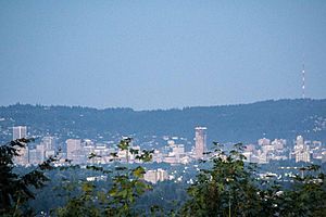
Rocky Butte from Interstate 205 in 2003
|
|
| Highest point | |
| Elevation | 613 ft (187 m) NAVD 88 |
| Geography | |
| Location | Multnomah County, Oregon, U.S. |
| Parent range | Boring Lava Field |
| Topo map | USGS Mount Tabor |
|
Rocky Butte Scenic Drive Historic District
|
|
| Lua error in Module:Location_map at line 420: attempt to index field 'wikibase' (a nil value). | |
| Location | Rocky Butte Rd. and parts of NE Fremont St. and 92nd Ave., Portland, Oregon, U.S. |
| Area | 21.5 acres (8.7 ha) |
| Built | 1933 |
| Built by | Multnomah Co. Road Dept. |
| NRHP reference No. | 91001550 |
| Added to NRHP | October 17, 1991 |
Rocky Butte (once called Wiberg Butte) is an old, inactive volcano in Portland, Oregon, United States. It's a type of volcano called a cinder cone, which is shaped like a cone and made of volcanic ash and rocks. Rocky Butte is part of the Boring Lava Field, a group of volcanoes and lava flows found across Oregon and Washington. This volcano last erupted a very long time ago, between 285,000 and 500,000 years ago.
Rocky Butte is considered a part of the Cascade Range, a chain of volcanoes. It formed when the Juan de Fuca tectonic plate slid under the North American tectonic plate. This process, called subduction, creates volcanoes. Rocky Butte is made of a type of volcanic rock called basaltic andesite, which contains shiny olivine crystals.
Over time, Rocky Butte has been home to many things. It once had a jail, colleges, and a military academy. Today, it still has a working but no longer used airway beacon (a light for planes). Portland Bible College and a campus for City Bible Church are also located here. The slopes of Rocky Butte are now home to Joseph Wood Hill Park and the Rocky Butte Natural Area. These areas have many different plants and animals, including thick forests. The Butte is right next to Interstate 205. It's a popular spot for hiking, climbing, and enjoying amazing views of other mountains from its top.
Contents
Exploring Rocky Butte's Location
Rocky Butte is located in the northeast part of Portland. It sits within the city limits, in Multnomah County, Oregon. It's one of several smaller volcanoes in or near Portland, like Mount Tabor and Powell Butte. Rocky Butte stands about 613 feet (187 meters) tall. The area around it is mostly flat, known as the Portland Delta.
The land around Portland changes a lot. It goes from flat river valleys to higher areas called terraces that are about 400 feet (122 meters) high. The Willamette Valley has hills over 1,000 feet (305 meters) tall. The Columbia River flows west through Portland, joining the Willamette River before heading north. These rivers have played a big role in shaping the land here.
Portland has a mild climate. It has long growing seasons, moderate rain, and mild winters. Summers are warm and dry. It usually doesn't freeze, with over 200 frost-free days each year. Temperatures can vary, but July usually stays below 80°F (27°C). January's average low is above 32°F (0°C). Most rain falls between October and March. July and August are the driest months.
How Rocky Butte Was Formed
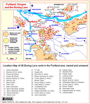
Rocky Butte is part of the Boring Lava Field. This area has over 80 small volcanoes and lava flows. Most of these are small cinder cones. Some are larger lava domes, which are like rounded hills of thick lava.
The Boring Lava Field is about 62 miles (100 kilometers) west of the main Cascade Range. It formed in a similar way to the Cascades. The Juan de Fuca tectonic plate slides under the North American tectonic plate. This process creates hot rock from deep inside the Earth's mantle.
Long ago, huge floods called the Missoula Floods (or Ice Age Floods) swept through this area. These floods happened between 21,000 and 15,000 years ago. They destroyed many small volcanoes and buried them under silt. But volcanoes with strong lava flows or volcanic plugs (hardened lava in the vent) survived. Rocky Butte was one of them. However, the floods heavily wore away the side of Rocky Butte facing the floodwaters.
Rocky Butte is a noticeable, stand-alone hill. It has two volcanic openings. It's the hard center of an old volcano that has been worn down by erosion. This volcano erupted basaltic andesite rock. Like other volcanoes in the Boring Lava Field, Rocky Butte's rock contains shiny olivine crystals. You can see this rock from the park at the top down to the roads below.
Scientists have found interesting minerals in the rocks from Rocky Butte. These include hornblende, pyroxene, tridymite, olivine, and hematite. It's unusual to find some of these minerals together.
The hill slopes down to the Columbia River floodplain. At lower levels, Rocky Butte has steep cliffs on its north and east sides. There's also a ditch, or fosse, at the base of Rocky Butte. This ditch is about 1 mile (1.6 kilometers) long. It opens towards the Columbia River. These features were likely shaped by the powerful floodwaters from the Missoula Floods.
When Rocky Butte Erupted
Scientists believe Rocky Butte is younger than 500,000 years old. One test showed its lava is about 285,000 years old. Local news sources say Rocky Butte is now an extinct volcano, meaning it won't erupt again.
When Rocky Butte erupted, its lava covered an older hill made of rocks from the Troutdale Formation. This shows that Rocky Butte erupted onto an uneven surface. This surface was later worn away by natural forces.
Plants and Animals of Rocky Butte
The mild climate and plenty of rain in this area help plants grow back quickly. Many forests here were cut down for farming or timber in the early 1900s. These cleared areas now have thick secondary forests. You can find plants like gorse, huckleberry, nettles, poison oak, salal, and blackberry. Many types of ferns grow here too. Fast-growing trees like alder and vine maple are also common.
The forests have tall trees like Douglas fir, western hemlock, and western redcedar. Other trees include Pacific dogwood, bigleaf maple, and Oregon ash. In wet areas, you might see the shrub Devil's club. Other common trees are black cottonwood. The forests also have shrubs like Indian plum, western hazel, and snowberry. On the ground, you'll find plants like sword fern and stinging nettle.
Today, about half of the Boring Lava region is still forested. But as more forests are cleared for homes, water quality has gotten worse. This means more dirt in the water and more flooding. Small streams in the area have clear, cool water. Many of them are home to tiny water bugs. Some also have amphibians and fish. The areas along the streams, called Riparian zones, have many different animal species. They also serve as pathways for birds, mammals, reptiles, and amphibians to move around.
The United States Fish and Wildlife Service has listed some "sensitive" species in the Boring Lava area. These are plants and animals that might be threatened or endangered.
- Sensitive Plants: White top aster, golden Indian paintbrush, tall bugbane, pale larkspur, peacock larkspur, Willamette daisy, water howellia, Bradshaw's lomatium, Kincaid's lupine, Howell's montia, Nelson's checkermallow, and Oregon sullivantia.
- Sensitive Animals: northwestern pond turtles, Willow flycatchers, several types of bats (like long-eared myotises and Yuma myotises), and northern red-legged frogs. Other sensitive animals include pileated woodpeckers, bald eagles, cutthroat trout, and coho salmon.
Rocky Butte's Past and Present
In the 1930s, workers from the Works Progress Administration (WPA) built a park at the top of Rocky Butte. This park, called Joseph Wood Hill Park, is about 600 feet (183 meters) high. Rocks from Rocky Butte were used to build the Multnomah County jail. Some rocks were also used to fix the Historic Columbia River Highway. There is also a communications tower on the south side of the volcano.
The Rocky Butte jail was finished in 1947. It was the main place for male prisoners in Multnomah County.
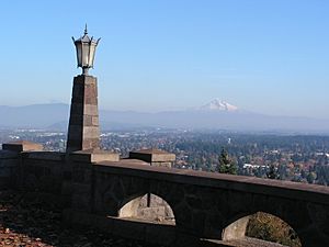
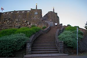
In 1934, the Rocky Butte Scenic Drive Historic District was created. This drive was part of a WPA project that helped 25,000 people find jobs in Portland. The drive goes all the way to the top of Rocky Butte, where there's a viewpoint overlooking Portland. Workers used basalt rock from a quarry on Rocky Butte to build stone walls. The project was designed to look natural and rustic. WPA workers also built the park and a fancy staircase at the top of Rocky Butte, finishing in 1939.
At its most popular in the 1940s, over 4,000 cars visited Rocky Butte every day. But over time, the park became run down and had fewer visitors. In the 1970s, the top became a place for teenage parties, and there was a lot of graffiti and trash. In the early 1990s, the Rocky Butte Preservation Society started cleaning up and fixing the park. They added new features like red cinder walkways and more trees. The District was added to the National Register of Historic Places in 1991.
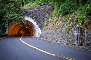
Other WPA projects included a tunnel 375 feet (114 meters) long at the south end of Rocky Butte. It was built between 1939 and 1941 to make it easier to reach the scenic views. Workers dug through layers of cinders and lava. The tunnel is curved because the volcano has a slight slope. The WPA's Rocky Butte project cost $500,000 in total.
The Hill Military Academy, a well-known military school, moved to Rocky Butte in 1931. Its campus covered 150 acres (0.6 square kilometers) on the north side of the volcano. The school closed in 1959. Today, Portland Bible College has a campus on Rocky Butte. The Grotto, a famous Catholic shrine, is also next to the volcano. It was created in 1924 and gets over 200,000 visitors each year. The Grotto has two levels, separated by Rocky Butte's 110-foot (34-meter) cliff. The upper level has the Chapel of St. Anne, which offers views of the Columbia River and Mount St. Helens. The City Bible Church also has a location at Rocky Butte.
At the top of Rocky Butte, a spinning airway beacon was put up in 1929. This light helped guide planes. Even though the light is still on, it was officially stopped being used in the late 1960s.
Fun Activities at Rocky Butte
Rocky Butte is part of the Rocky Butte Natural Area, which covers about 17.28 acres (0.07 square kilometers). The very top of Rocky Butte is a city park called Joseph Wood Hill Park. This park is 2.38 acres (0.01 square kilometers) big. From the park, you can see the Boring Lava Field, Mount St. Helens, and Mount Hood. The park has red, crushed stone paths, a stone wall, and a stone stand with a metal plaque. Rocky Butte is a popular place to see mountains. In 2017, the Portland Parks & Recreation bureau planned to clear some trees and unwanted plants to make the views of downtown Portland and the mountains even better. They planned to plant new, smaller trees and shrubs.
Rocky Butte doesn't have many official trails. There are some paths made by people who hike and bike on the lower parts of the mountain. There are also climbing paths near the top. These paths are not fenced and can be risky. One walking path starts from NE 92nd Avenue and Skidmore Street. It's about 1.25 miles (2 kilometers) each way and takes 1.5 to 2 hours. This path goes past the Rocky Butte Tunnel and the old Hill Military Academy. Dogs can be off-leash on the trails, but must be on a leash in Joseph Wood Hill Park.
Rocky Butte is also a popular place for rock climbing in the Portland area. Climbers started using it in the 1970s and 1980s. Many of the climbing routes are set up for top-roping, which is a safer way to climb. The climbing routes are not suitable for dogs or children. Some of the most popular climbs are on a section called Video Bluff. Rocky Butte offers many different types of climbs, including cracks, dihedrals, slab climbs, and overhanging routes.
|
 | Mary Eliza Mahoney |
 | Susie King Taylor |
 | Ida Gray |
 | Eliza Ann Grier |


