
Airway beacon facts for kids


An airway beacon (also called an aerial lighthouse) was like a giant lighthouse for airplanes. It was a bright, spinning light on top of a tall tower. These beacons helped airplane pilots find their way, especially at night, long before today's advanced navigation systems.
Pilots used these lights to follow specific air routes, almost like following a lighted path in the sky. They were very important for guiding aircraft in the early days of flying, both in the United States and across Europe.
Contents
Airway Beacons in Europe
United Kingdom's Aerial Lighthouses
During the 1920s and 1930s, many aerial lighthouses were built across the United Kingdom and other parts of Europe. These lights helped guide planes from one place to another.
Over time, new technologies like radio navigation systems made these lighthouses less necessary. Modern systems, such as NDB (Non-Directional Beacon) and VOR (VHF Omnidirectional Range), use radio signals to guide planes.
Today, only one aerial lighthouse is still working in the United Kingdom. It sits on top of the main building at RAF Cranwell, which is a Royal Air Force college.
Netherlands' Unique Markers


In the Netherlands, large structures called gas holders were sometimes used as navigation aids. These huge tanks, which stored gas, were painted with a big arrow pointing north. They also had two letters painted on them to show pilots their exact location.
Airway Beacons in the United States
In the United States, about 1,500 airway beacons were built to help pilots fly across the country. These beacons covered a huge distance of about 18,000 miles (29,000 km).
Most of these old beacons have been taken down now. However, the state of Montana still uses some of them to help pilots navigate in its mountainous areas. One beacon is kept for history in Saint Paul, Minnesota, at Indian Mounds Park. It sits on a hill overlooking the Mississippi River.
Another beacon has been working continuously since 1929 at Rocky Butte in Portland, Oregon. Even though it was officially stopped in the 1960s, it still lights up the sky. A beacon in Grants, New Mexico, was also recently fixed up for historical reasons.
Near the bottom of each beacon tower, there was often a large concrete slab shaped like an arrow. These arrows pointed the way to the next beacon. Many of these arrows can still be seen today, even from satellite pictures!
How Airway Beacons Worked
Airway beacons had two main types of lights to help pilots:
The White Rotating Light
The main part of an airway beacon was a powerful white light that spun around. This light used a large 24-inch (610 mm) mirror and a strong 1,000-watt bulb. It spun at 6 rotations per minute, making a quick flash every ten seconds. On a clear night, pilots could see this bright flash from as far as 40 miles (64 km away).
Some modern versions of these beacons in Montana now have newer light systems inside clear domes.
Colored Course Lights
Below the main white beacon, there were special colored lights called "course lights." These lights pointed along the specific air route.
- Red lights meant the beacon was located between two landing fields.
- Green lights meant the beacon was right next to or on a landing field (an airport).
These course lights would flash a special Morse code letter. This letter helped pilots identify which beacon they were seeing. Each beacon along an airway had a unique number and a Morse code ID. There were 10 different letters used: W, U, V, H, R, K, D, B, G, or M. These letters stood for the numbers 1 through 10.
For example, a dot in Morse code would flash for 0.5 seconds, and a dash would flash for 1.5 seconds. There was a short pause between each dot or dash, and a longer pause between each letter.
To help pilots remember the letters and their order, they often memorized a phrase: "When Undertaking Very Hard Routes, Keep Direction By Good Methods." This phrase helped them remember the sequence of letters (W, U, V, H, R, K, D, B, G, M).
Pilots would look at their navigation charts, which showed the beacon numbers and their Morse code patterns. For example, if a beacon was number 15, its code digit would be 5 (the last digit), which meant the letter R (Morse code: "dit dah dit" or ·−·).
History of US Airway Beacons
The first airway beacons in the United States were built by the Post Office and the Department of Commerce. This happened between 1923 and 1933. These beacons were crucial for guiding early airmail flights.
Around 1929, a new system called the Low Frequency Radio Range began to replace these visual beacons. This new system used radio signals, which were more reliable, especially in bad weather.
Most of the visual airway beacons were officially shut down by 1973. However, as mentioned, a few are still working in Portland, Oregon, and in Western Montana. The ones in Montana are even shown on aviation maps for pilots in that area. The Montana Department of Transportation Aeronautics Division helps keep them running.
Images for kids
-
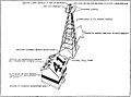
Illustration of Airway beacon, showing designated number. In this example, for units digit "1", Morse code should be ".--" (W).
-
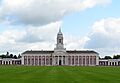
The last operational aerial lighthouse in the UK, at the RAF College main building at RAF Cranwell in Lincolnshire
-
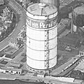
Gas holder Goliath in Eindhoven (designated by the letters EH) in the 1930s
-
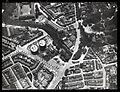
Two gasholders in Leeuwarden.
-
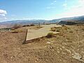
Remnants of Transcontinental Air Mail Route Beacon 37A, atop a bluff in St. George, Utah, with concrete arrow indicating the direction to the next beacon
-
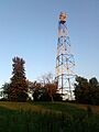
An airway beacon in Saint Paul, Minnesota, built in 1929 and restored in the 1990s. It sits on top of a 110-foot (34 m) steel tower in Indian Mounds Park.

