Portland metropolitan area, Oregon facts for kids
Quick facts for kids
Portland Metropolitan Area
|
|
|---|---|
| Portland–Vancouver–Hillsboro, OR–WA Metropolitan Statistical Area | |

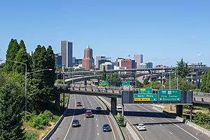
Portland skyline from the Ross Island Bridge
|
|
| Country | United States |
| State | Oregon Washington |
| Largest city | Portland |
| Other cities | - Vancouver - Gresham - Hillsboro - Beaverton - Tigard - Oregon City - Milwaukie |
| Area | |
| • Total | 6,684 sq mi (17,310 km2) |
| Highest elevation | 11,249 ft (3,429 m) |
| Lowest elevation | 0 ft (0 m) |
| Population
(2020)
|
|
| • Total | 2,512,859 |
| • Estimate
(2022)
|
2,509,489 |
| • Rank | 25th in the U.S. |
| • Density | 367/sq mi (129/km2) |
| GDP | |
| • Portland (MSA) | $204.3 billion (2022) |
| Time zone | UTC−8 (PST) |
| • Summer (DST) | UTC−7 (PDT) |
| Area code(s) | 503, 971, 360 & 564 |
The Portland metropolitan area is a large urban region in the United States. It includes parts of two states: Oregon and Washington. The biggest city in this area is Portland, Oregon.
The U.S. government calls this area the Portland–Vancouver–Hillsboro, OR–WA Metropolitan Statistical Area. This name helps the United States Census Bureau keep track of population and other important facts. The area includes seven counties: Clackamas, Columbia, Multnomah, Washington, and Yamhill in Oregon, plus Clark and Skamania in Washington. In 2020, about 2.5 million people lived here. That's a lot of people!
The Oregon part of this metro area is the largest urban center in Oregon. The Washington part is the third largest in Washington state, after Seattle and Spokane. Some parts of the Portland metro area are managed by a special government called Metro. This group helps with things like planning how land is used in the region.
Contents
Understanding the Portland Metro Area
A "metropolitan statistical area" (MSA) is a region that includes a large city and its surrounding areas. These areas are closely connected socially and economically. This means many people live in the smaller towns and commute to the main city for work or other activities.
Population Growth Over Time
The Portland metro area has grown a lot over the years. Here's how the population has changed:
| Historical population | |||
|---|---|---|---|
| Census | Pop. | %± | |
| 1860 | 16,751 | — | |
| 1870 | 30,763 | 83.6% | |
| 1880 | 57,831 | 88.0% | |
| 1890 | 130,455 | 125.6% | |
| 1900 | 172,056 | 31.9% | |
| 1910 | 330,581 | 92.1% | |
| 1920 | 409,023 | 23.7% | |
| 1930 | 500,011 | 22.2% | |
| 1940 | 553,215 | 10.6% | |
| 1950 | 766,008 | 38.5% | |
| 1960 | 881,961 | 15.1% | |
| 1970 | 1,083,977 | 22.9% | |
| 1980 | 1,341,491 | 23.8% | |
| 1990 | 1,523,741 | 13.6% | |
| 2000 | 1,927,881 | 26.5% | |
| 2010 | 2,226,009 | 15.5% | |
| 2020 | 2,512,859 | 12.9% | |
| 2022 (est.) | 2,509,489 | 12.7% | |
| U.S. Decennial Census 2020 Census |
|||
People Living in the Metro Area
In 2020, the population of the Portland metro area was 2,512,859 people. In 2010, there were 2,226,009 people living here. This shows a big increase in just ten years!
The people living in the Portland metro area come from many different backgrounds. This makes the area a diverse and interesting place to live. In 2010, the average household income was about $53,078 per year. For families, it was about $64,290 per year.
The Portland–Vancouver–Hillsboro Metropolitan Statistical Area is the 23rd largest in the United States. Most of its residents, about 1.7 million, live in Oregon. The rest, about 436,000, live in Washington.
Portland-Vancouver-Salem Combined Statistical Area
Beyond the main Portland metro area, there's an even larger region called the Portland–Vancouver–Salem, OR–WA Combined Statistical Area (CSA). This bigger area includes several smaller metro areas that are all connected.
As of 2022, this CSA includes five different Metropolitan Statistical Areas. They cover nine counties in Oregon and three counties in Washington.
- The main Portland–Vancouver–Hillsboro area (7 counties).
- The Salem, OR Metropolitan Statistical Area (2 counties).
- The Albany, OR Metropolitan Statistical Area (1 county).
- The Longview, WA Metropolitan Statistical Area (1 county).
- The Corvallis, OR Metropolitan Statistical Area (1 county).
In 2022, the total population for this larger combined area was estimated to be over 3.2 million people. This makes it the 19th largest combined statistical area in the United States.
Cities and Towns in the Region
The Portland metro area is made up of many cities and smaller communities.

Major Cities
Besides Portland, here are some of the other important cities in the area:
Other Communities
Many other smaller cities and towns are part of the metro area. Some of these include:
- Battle Ground
- Camas
- Cornelius
- Fairview
- Forest Grove
- Gladstone
- Happy Valley
- King City
- Lake Oswego
- Milwaukie
- Oregon City
- Sherwood
- Tigard
- Troutdale
- Tualatin
- West Linn
- Wilsonville
- Wood Village
- Washougal
- Ridgefield
- La Center
- Yacolt
There are also many smaller communities that are not officially cities but are still part of the suburban area.
Getting Around: Transportation in Portland
Portland is a hub for major highways in the Pacific Northwest. Interstate 5 and Interstate 84 are two very important roads that meet here. Other key roads include Interstate 205, which goes around the east side of the city, and U.S. Route 26, which heads west towards the Oregon Coast.
Public Transportation
Public transportation is a big part of getting around the Portland area.
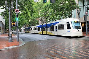
- In Oregon, TriMet provides bus and light rail services.
- Other local agencies like Sandy Area Metro and Canby Area Transit serve smaller towns.
- In Washington, C-Tran offers transit services in Clark County.
- There's even a bus service called Columbia County Rider that connects towns like St. Helens to downtown Portland.
Major Airports
If you need to fly, the main airport is the Portland International Airport. There are also smaller airports nearby:
- Portland-Hillsboro Airport
- Salem Municipal Airport
- Portland-Troutdale Airport
Train Travel
You can also travel by train! Amtrak trains stop at Portland Union Station.
- The Coast Starlight train travels between Los Angeles and Seattle.
- The Cascades connects Eugene to Vancouver, BC.
- The Empire Builder train goes east all the way to Chicago.
Major Highways in the Area
Here are some of the main highways that help people travel through the Portland metro area:
 Interstate 5
 Interstate 84
 Interstate 205
 Interstate 405
 U.S. Route 26
 U.S. Route 30
 OR 8
OR 8 OR 18
OR 18 OR 43
OR 43 OR 99E
 OR 99W
 OR 217
 State Route 14
 State Route 500
Sports Teams in Portland
The Portland metro area is a great place for sports fans! It has many professional and semi-professional sports teams.
- Basketball: The Portland Trail Blazers play in the NBA.
- Soccer: The Portland Timbers are part of Major League Soccer, and the Portland Thorns FC play in the National Women's Soccer League.
- Rugby: The Portland Loggers play in the North American Rugby League.
- Baseball: You can also cheer for the Portland Pickles and the Hillsboro Hops.
Portland is also home to two major universities with Division 1 sports teams: the Portland State Vikings and the Portland Pilots. Many amateur sports events, including high school rugby championships, are held here too.
See also
 In Spanish: Área metropolitana de Portland para niños
 | William Lucy |
 | Charles Hayes |
 | Cleveland Robinson |


