Washougal, Washington facts for kids
Quick facts for kids
Washougal, Washington
|
|
|---|---|

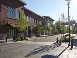
Downtown Washougal facing west
|
|
| Motto(s):
Gateway to the Gorge
|
|

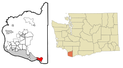
Location of Washougal, Washington
|
|
| Country | United States |
| State | Washington |
| County | Clark |
| Government | |
| • Type | Council–manager |
| Area | |
| • Total | 6.83 sq mi (17.68 km2) |
| • Land | 5.95 sq mi (15.41 km2) |
| • Water | 0.88 sq mi (2.27 km2) |
| Elevation | 82 ft (25 m) |
| Population
(2020)
|
|
| • Total | 17,039 |
| • Estimate
(2022)
|
16,926 |
| • Density | 2,707.06/sq mi (1,045.24/km2) |
| Time zone | UTC-8 (PST) |
| • Summer (DST) | UTC-7 (PDT) |
| ZIP code |
98671
|
| Area code | 360 |
| FIPS code | 53-76405 |
| GNIS feature ID | 2412189 |
Washougal (wah-SHOO-gəl) is a city located in Clark County, Washington, in the United States. In 2020, about 17,039 people lived there.
Contents
What's in a Name? The Origin of Washougal
The name Washougal comes from a word in the Chinookan language. Its exact meaning is debated. A fur trader named Alexander Ross first wrote down the name in 1811 as "Wasough-ally." Over time, it was also spelled "Washougally," "Wa-Shu-Go," and "Washookal."
A Look Back: The History of Washougal
The land where Washougal is now was first home to the Watlala people. They were an indigenous group who spoke a Chinookan language. Their villages were built along the Columbia River.
Early Explorers and Settlers
In 1805 and 1806, the Corps of Discovery visited the area. This group was led by Meriwether Lewis and William Clark. They camped near the Washougal River in April 1806. They thought about naming it the "Seal River."
An English sailor named Richard Ough built a home here between 1838 and 1841. He worked for the Hudson's Bay Company at Fort Vancouver. He later married the daughter of a local Chinook chief.
In 1844, David C. Parker led a group of settlers. They built Parker's Landing and claimed a large area of land. This was done under the Donation Land Claim Act, which allowed settlers to claim land. One of these settlers was George Bush, an early African American settler in the Pacific Northwest.
Growing into a Town
Parker's Landing, later called Parkersville, tried to become an official town in 1852 or 1854. By then, it had a hotel, a bar, and a store. It was an important trading spot along the river.
A public school was started in 1852–53. It is believed to be the first American school north of the Columbia River. In 1880, Joseph E. C. Durgin bought part of Ough's land. He created a new townsite called Washougal. This new settlement grew faster than Parkersville. It was officially mapped out, or platted, on May 6, 1880.
Modern Washougal
Washougal became connected to the Spokane, Portland and Seattle Railway in 1908. It officially became a city in November of that year. In 1910, a factory that made cloth, called a textile mill, opened. It became a big part of the local economy. Two years later, Pendleton Woolen Mills bought the factory.
A new highway along the Columbia River opened in 1927. This road, now part of State Route 14, helped more people build summer homes and recreation spots near Washougal. In the mid-to-late 1900s, Washougal became a bedroom community. This means many people lived in Washougal but worked in nearby cities like Vancouver and Portland.
Washougal's Mount Pleasant Grange Hall is special. It is the oldest grange hall in Washington that has been used continuously.
Exploring Washougal's Geography
Washougal is located about 18 miles (29 km) east of Vancouver. It sits on the north bank of the Columbia River. To its west is the city of Camas. State Route 14 connects Washougal to other cities.
The Washougal River flows along the north side of downtown. It is a tributary (a smaller river that flows into a larger one) of the Columbia River. The Washougal River also separates the city from Camas. Washougal is the southernmost city in Washington state.
Land and Water
The city covers a total area of about 6.30 square miles (16.32 km2). Of this, about 5.42 square miles (14.04 km2) is land, and 0.88 square miles (2.28 km2) is water.
Washougal's Climate
Washougal has warm, dry summers. The average monthly temperatures do not go above 71.6 °F (22 °C). This type of weather is called a warm-summer Mediterranean climate. It is often shown as "Csb" on climate maps.
| Climate data for Washougal, Washington (1975–present) | |||||||||||||
|---|---|---|---|---|---|---|---|---|---|---|---|---|---|
| Month | Jan | Feb | Mar | Apr | May | Jun | Jul | Aug | Sep | Oct | Nov | Dec | Year |
| Record high °F (°C) | 64 (18) |
72 (22) |
82 (28) |
89 (32) |
100 (38) |
105 (41) |
108 (42) |
107 (42) |
105 (41) |
93 (34) |
71 (22) |
64 (18) |
108 (42) |
| Mean daily maximum °F (°C) | 45.0 (7.2) |
49.7 (9.8) |
54.9 (12.7) |
59.6 (15.3) |
66.7 (19.3) |
72.2 (22.3) |
79.4 (26.3) |
79.9 (26.6) |
74.4 (23.6) |
63.6 (17.6) |
51.4 (10.8) |
44.5 (6.9) |
61.8 (16.6) |
| Daily mean °F (°C) | 37.7 (3.2) |
40.9 (4.9) |
44.3 (6.8) |
47.7 (8.7) |
53.5 (11.9) |
58.6 (14.8) |
63.4 (17.4) |
63.3 (17.4) |
58.6 (14.8) |
50.8 (10.4) |
43.1 (6.2) |
37.8 (3.2) |
50.0 (10.0) |
| Mean daily minimum °F (°C) | 30.5 (−0.8) |
32.0 (0.0) |
33.7 (0.9) |
35.8 (2.1) |
40.3 (4.6) |
45.0 (7.2) |
47.5 (8.6) |
46.7 (8.2) |
42.8 (6.0) |
38.0 (3.3) |
34.9 (1.6) |
31.2 (−0.4) |
38.2 (3.4) |
| Record low °F (°C) | 5 (−15) |
3 (−16) |
15 (−9) |
21 (−6) |
22 (−6) |
29 (−2) |
32 (0) |
33 (1) |
26 (−3) |
17 (−8) |
11 (−12) |
— | 3 (−16) |
| Average precipitation inches (mm) | 12.2 (310) |
9.1 (230) |
8.4 (210) |
6.7 (170) |
5.1 (130) |
4.0 (100) |
1.2 (30) |
1.9 (48) |
3.6 (91) |
6.8 (170) |
12.2 (310) |
13.0 (330) |
84.2 (2,140) |
| Average snowfall inches (cm) | 3.3 (8.4) |
1.6 (4.1) |
0.5 (1.3) |
0.0 (0.0) |
0.0 (0.0) |
0.0 (0.0) |
0.0 (0.0) |
0.0 (0.0) |
0.0 (0.0) |
0.0 (0.0) |
1.0 (2.5) |
3.6 (9.1) |
10.0 (25) |
| Average precipitation days (≥ 0.01 in.) | 20 | 17 | 20 | 19 | 15 | 11 | 6 | 6 | 9 | 15 | 21 | 21 | 180 |
| Average snowy days (≥ 0.1 in.) | 1.6 | 0.9 | 0.3 | 0.0 | 0.0 | 0.0 | 0.0 | 0.0 | 0.0 | 0.0 | 0.4 | 1.6 | 4.8 |
| Source: Weatherbase | |||||||||||||
Who Lives Here? Washougal's Population
| Historical population | |||
|---|---|---|---|
| Census | Pop. | %± | |
| 1910 | 456 | — | |
| 1920 | 765 | 67.8% | |
| 1930 | 1,206 | 57.6% | |
| 1940 | 1,267 | 5.1% | |
| 1950 | 1,577 | 24.5% | |
| 1960 | 2,672 | 69.4% | |
| 1970 | 3,388 | 26.8% | |
| 1980 | 3,834 | 13.2% | |
| 1990 | 4,764 | 24.3% | |
| 2000 | 8,595 | 80.4% | |
| 2010 | 14,095 | 64.0% | |
| 2020 | 17,039 | 20.9% | |
| 2022 (est.) | 16,926 | 20.1% | |
| U.S. Decennial Census 2020 Census |
|||
The population of Washougal has grown a lot over the years. In 1910, only 456 people lived there. By 2020, the population had grown to 17,039 people.
Facts from the 2020 Census
In 2020, there were 17,039 people living in Washougal. There were 6,027 households (groups of people living together). The population density was about 2,864 people per square mile. This means a lot of people live in a small area.
Most people in the city, about 89.4%, were White. About 0.9% were African American, and 0.8% were Native American. About 2.2% were Asian, and 5.9% were from two or more races.
The average household had 2.76 people. About 22.9% of the population was under 18 years old. About 15.1% of people were older than 65. The city had slightly more females (51.4%) than males (48.6%).
Facts from the 2010 Census
In 2010, Washougal had 14,095 people and 5,256 households. The average household size was 2.68 people. About 38% of households had children under 18. Most households (55.3%) were married couples living together.
The average age in the city was 36.1 years. About 26.9% of residents were under 18. About 10.1% were 65 or older. The population was almost evenly split between males (49.7%) and females (50.3%).
Fun and Games: Parks and Recreation
Washougal has many places for outdoor fun and relaxation. These include several public parks. Angelo Park, Beaver Park, Campen Creek Park, and Hathaway Park are four large parks in the city. You can also enjoy fishing on the Washougal River. Steelhead trout and salmon are often found there.
Global Friends: Sister City
Washougal has a special connection with another city in the world. This is called a Sister City relationship.
See also
 In Spanish: Washougal (Washington) para niños
 | Kyle Baker |
 | Joseph Yoakum |
 | Laura Wheeler Waring |
 | Henry Ossawa Tanner |


