
Oregon Coast facts for kids


The Oregon Coast is a beautiful coastal area in the U.S. state of Oregon. It's next to the Pacific Ocean on the west and the Oregon Coast Range mountains on the east. This region stretches about 362 miles (583 km) from the California border in the south to the Columbia River in the north. It's not just one type of land; it includes different environments, even the Columbia River Estuary where the river meets the ocean.
A special law called the Oregon Beach Bill from 1967 makes sure that everyone can visit the beaches for free. This law helps protect the beaches for public use.
The Oregon Coast is usually thought of as three main parts:
- The North Coast, which goes from the Columbia River to Cascade Head.
- The Central Coast, which stretches from Cascade Head to Reedsport.
- The South Coast, which goes from Reedsport to the Oregon–California border.
The biggest city on the coast is Coos Bay, with about 16,700 people. It's located in Coos County on the South Coast. U.S. Route 101 is the main highway that runs along the coast from Brookings to Astoria. It's famous for its amazing views of the Pacific Ocean. More than 80 state parks and recreation areas are found along the Oregon Coast, offering many places to explore.
The Oregon Coast includes several counties: Clatsop, Tillamook, Lincoln, western Lane, western Douglas, Coos, and Curry.
Contents
Exploring the Geography of the Oregon Coast

The Oregon Coast is divided into three main areas based on its geology (how the land is formed): the North Coast, Central Coast, and South Coast. Along the shoreline, you'll mostly see three types of landforms: tall sea cliffs, sandy beaches, and sea stacks (tall rock formations in the water).
North Coast: Sandy Shores and River Influence

The North Coast stretches from the Columbia River to Cascade Head. It has long, unbroken sandy beaches because of the silt (fine sand and mud) that washes south from the Columbia River. This area also has more logging zones and larger bays that are often enclosed by sandbars.
Astoria is an important city here, helping ships enter and leave the Columbia River. This is because of the dangerous Columbia Bar, where the river meets the ocean. Ships need special pilots to guide them safely. Other cities on this coast include Seaside, Cannon Beach, and Tillamook. Seaside and Cannon Beach are right on the ocean, while Tillamook is a bit inland along Tillamook Bay.
Because much of this region is low-lying, flooding is a common problem, especially in winter when storms come in from the Pacific. Tillamook is often affected because it's on a major floodplain. The weather here is mild. Winters are cool and wet, with average lows around 40°F (4°C) and highs around 50°F (10°C). Summers are drier and warmer, with highs reaching about 70°F (21°C) in early September.
Central Coast: Cliffs and Bays
.jpg)
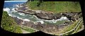
The Central Coast goes from Cascade Head to Reedsport. It has fewer sandy beaches than the North Coast but more sea cliffs and terraces. There are also more bays here. You'll find small towns like Lincoln City, Depoe Bay, Newport, Waldport, and Yachats. These towns are usually small because the land is squeezed between the mountains and the ocean.
You'll often see exposed sandstone cliffs along the beaches and highways. These sandstones were lifted up during the Neogene period. The higher layers are often orange and soft, while lower layers are harder and gray-brown. The weather here is similar to the North Coast, but summers tend to have more sunny or partly cloudy days.
South Coast: Mountains and Unique Forests

The South Coast stretches from Reedsport to the California border. It's different from the other two regions because it's very mountainous. This is due to ancient tectonic uplift (when Earth's crust pushes up) and terrane accretion (when pieces of land join together). Much of this coastline has sea cliffs and miles of beaches. You'll also find the famous Oregon Dunes here.
Seven cities are on the South Coast: Reedsport, North Bend, Coos Bay, Bandon, Port Orford, Gold Beach, and Brookings. Cape Blanco, near Port Orford, is the westernmost point in Oregon. The types of trees change here too. You'll see fewer western redcedar and Sitka spruce forests, and more coast redwood, Port Orford cedar, and Douglas-fir trees, along with Oregon Myrtle. The weather is similar to the other coasts, but summers here have even more sunny or partly cloudy days, sometimes up to 90%.
Coastal Communities: Cities to Explore

Many towns and cities are dotted along the Oregon Coast, each with its own charm. Here are some of the main cities:
- Astoria
- Bandon
- Bay City
- Brookings
- Cannon Beach
- Coos Bay
- Depoe Bay
- Florence
- Garibaldi
- Gearhart
- Gold Beach
- Lincoln City
- Manzanita
- Newport
- North Bend
- Port Orford
- Reedsport
- Rockaway Beach
- Seaside
- Tillamook
- Waldport
- Warrenton
- Yachats
Ecology: Plants and Animals of the Coast

The Oregon Coast is home to many different kinds of plants and animals, both on land and in the ocean. In the past, human activities caused some animal species, like the sea otter, to decline. However, strict rules and conservation efforts have helped some species return in recent years.
The Oregon Coast is also where you'll find the Oregon Coast National Wildlife Refuge Complex. This is a group of six wildlife refuges covering 371 acres (1.5 km²) over 320 miles (515 km) of coastline.
Land Animals and Plants

The coast has a wide variety of plants due to its climate and terrain. In some areas, large trees are rare because strong winter storms and poor soil limit their growth. Shore pine (Pinus contorta subsp.contorta) trees are common in these spots. However, you can also find different types of fir, pine, and cedar trees, including some unique ones like the Port Orford cedar (Chamaecyparis lawsoniana). Because of these forests, logging has been an important industry here.
Close to the shore, only tough small plants can grow because of the salt carried by the wind. Coastal strawberry and Pacific silverweed are common because they can handle the salt.
In the forests, you might see large animals like the Roosevelt elk and black-tailed deer. Bobcats and North American cougars also live here. Smaller animals like nutrias, Virginia opossums, and Townsend's moles can be found in lowland areas.
Marine Life: Ocean Wonders

The ocean life off the Oregon Coast is incredibly diverse. More than 29 types of marine mammals live here. This includes several kinds of seals, like the Steller's sea lion and harbor seal. You might also spot the less common northern elephant seal and California sea lion. Places like the Sea Lion Caves near Florence and the bay front in Newport are great for seeing sea lions and harbor seals. Sometimes, seal pups are seen resting on sandy beaches. It's important not to disturb them, as it's against the law.
Sadly, sea otters used to live here but were hunted to extinction. However, one was spotted in 2009, the first in over 100 years! Occasionally, large Humboldt Squid wash up on beaches after following warm currents that become too cold for them.
Several types of whales can be seen in the waters, especially during their migrations in late December and late March. These include gray whales, orcas (killer whales), and humpback whales. Harbor porpoises are also common. Whale watching is a popular activity, and you can often see them from tour boats or even from shore.

Tidepools are amazing, small ecosystems found along Oregon's rocky shores. They are home to hundreds of animal species. You'll see red, green, and brown algae. Many invertebrates (animals without backbones) live in these tidepools, such as sponges, sea anemones, mussels, sea stars, limpets, crabs, shrimp, barnacles, sea urchins, and sea cucumbers. Sunset Bay State Park and Strawberry Hill are great places to explore tidepools.
Underwater, you'll find kelp forests and rock reefs. These areas provide shelter for much of Oregon's marine life, including many types of fish like rockfish, flatfish, and greenlings.
Coastal Birds: Feathered Friends

Many different birds live on the Oregon Coast, making bird watching a popular hobby. Birds here can be grouped into four types:
- Seabirds spend most of their lives at sea and are built for ocean living. They eat small fish, squid, and shellfish. Examples include the common murre, tufted puffin, and various cormorants.
- Shorebirds don't have webbed feet and search for food along the shore, eating worms, insect larvae, and crustaceans. The western sandpiper and western snowy plover are common shorebirds.
- Birds of prey hunt small birds, rodents, and mammals. These include the bald eagle, barn owl, and osprey.
- Waterfowl like ducks and geese live in the freshwater areas near the coast.
Sharks of the Oregon Coast

The waters off the Oregon Coast are home to 16 different species of sharks! Some of them include:
- Basking shark
- Blue shark
- Broadnose sevengill shark
- Common thresher shark
- Leopard shark
- Salmon shark
- Shortfin mako shark
- Spiny dogfish
- White shark
While sharks are present, bites are very rare. Usually, one or two shark bites are reported each year, often involving boats or surfboards. Human bites are even rarer, with only 25 reported since 1900. Every person bitten in Oregon has survived.
History of the Oregon Coast

It's believed that the first indigenous peoples arrived in this region about 11,000 to 13,000 years ago. They were likely drawn by the rich natural resources. Not much is known about these very early people. Over time, several tribes and language groups formed along the coast, including the Clatsop, Tillamook, Alsea, Siuslaw, Coos, and Coquille. These tribes lived similar lives, often relying on seafood like clams, salmon, and seals, as well as berries. Most settlements were permanent because there was plenty of food.
European Exploration (1775–1811)
European explorers began sailing along the Oregon Coast in the 1700s. Spanish sailors, like Juan José Pérez Hernández in 1774 and Bruno de Heceta in 1775, explored the region. Heceta Head was later named after Bruno de Heceta.
British explorers like Sir Francis Drake (in the 1500s) and later James Cook and George Vancouver (in the 1700s) also explored the area. Vancouver made the most detailed maps of the region.
American Captain Robert Gray visited the Oregon Coast in 1788. In 1792, he returned and discovered the mouth of a large river, which he named the Columbia River.
The Lewis and Clark Expedition

In 1803, after the U.S. bought the Louisiana Territory, President Thomas Jefferson sent an expedition to the west coast. This was the famous Lewis and Clark Expedition, led by Captain Meriwether Lewis and William Clark. They reached the Oregon Coast in late 1805 and built Fort Clatsop near what is now Astoria. During their stay, they observed the land and wildlife and built relationships with the local Clatsop Indians. The expedition returned east in March 1806. Their journey had a big impact, encouraging future settlement of the U.S. west coast.
Pioneer Settlement (1811–1859)
In 1811, John Jacob Astor's Pacific Fur Company set up a trading post at the mouth of the Columbia River, creating Astoria, the first permanent U.S. settlement in the area. However, it wasn't very profitable and was sold to a British company in 1812. As more American pioneers traveled to Oregon on the Oregon Trail, British claims to the land slowly faded. In 1846, the Oregon Treaty was signed, officially making Oregon part of the United States.
From 1860 to Today

After Oregon became a state in 1859, land development quickly began along the coast's bays and rivers. Logging and commercial fishing became the main industries, and ports were built to support them. Lighthouses were also built to help guide ships, with the first at Cape Blanco in 1870.
However, in 1874, the state began selling public beach lands to private owners. This led to resorts being built. In 1911, Governor Oswald West promised to make Oregon's beaches public again. He argued that the beaches were needed for transportation. In 1913, the Oregon legislature declared the entire ocean shore from the Columbia River to California a state highway. This decision helped create U.S. Route 101 along the coast. The Parks and Recreation Department also bought land for 36 state parks along the highway, about one every 10 miles (16 km). With the highway and parks, tourism on the coast grew rapidly. In recent years, the logging and fishing industries have declined due to economic changes and new regulations.
The 1967 Oregon Beach Bill
Oregon's public beach access was challenged in 1966 when a motel owner fenced off a beach area for his guests. In response, state lawmakers proposed the Oregon Beach Bill to make the beaches public again. To gain public support, Governor Tom McCall created a dramatic media event in 1967, flying helicopters to the beach with surveyors. This led to huge public demand for the bill, which passed and was signed into law on July 6, 1967.
The Beach Bill states that all "wet sand" (within 16 vertical feet (4.9 m) of the low tide line) belongs to the state. It also allows public access to all beach areas up to the line of vegetation, even if the land is privately owned. This means the public has "free and uninterrupted use of the beaches." Property owners need state permits for building on the ocean shore. This law has helped keep Oregon's beautiful beaches open for everyone to enjoy.
Tourism: Fun on the Oregon Coast

The Oregon Coast is a very popular place to visit because of its amazing scenery, wildlife, and history. Many activities are popular here, including Hiking, sport fishing, cycling, kite flying, scuba diving, surfing, sandboarding, and boating. Historic places like Fort Clatsop, Battle Rock, and Oregon's many lighthouses are big draws for visitors. The coast also has beautiful scenic spots like Cape Perpetua and Cape Blanco. Each region has its own special attractions, such as the Astoria Column in Astoria or the Oregon Coast Aquarium in Newport.
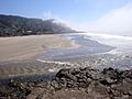
Beaches: Sand, Surf, and Fun

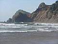
Oregon's beaches are a major attraction. Activities like horse riding, clam digging, and surfing are very popular. Some beaches host events like Seaside's Beach Volleyball Tournament. Because of the many headlands (rocky points of land) along the coast, beaches vary in length from many miles to less than a quarter of a mile. While most are sandy, some beaches have smooth stones.
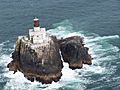
Lighthouses: Guiding Lights

Visiting Oregon's historic lighthouses is another popular activity. Most of them were built before 1900. The Oregon and Washington coasts were once considered some of the most dangerous seas in the world, so lighthouses and even a lightship were built to help sailors. Of the original 12 lights, nine are still in use today.
Outdoor Adventures

The Oregon Coast offers many outdoor activities. Hiking, camping, sport fishing, and cycling are common everywhere. Sport fishing has traditionally been a main activity and is a big industry in cities like Astoria, Newport, and Coos Bay. Oregon has strict rules for fishing to protect the fish populations. Charter boats often take groups out for fishing trips to catch Chinook salmon, Coho salmon, and Pacific halibut.
Other activities, like riding All-terrain vehicles (ATVs) and sandboarding, are popular in the Oregon Dunes National Recreation Area. Many shops rent equipment for these activities. Horse riding is also common on many beaches and dunes, with trails in nearby forests.
Surfing and bodyboarding are popular sports on the beaches almost all year round, no matter the weather or water temperature. The coast also has excellent golf courses, including Bandon Dunes, which is highly ranked.
Historic Sites: A Glimpse into the Past

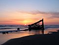
Many historical sites are found along the Oregon Coast. One of the most famous is Fort Clatsop near Astoria. This was where the Lewis and Clark Expedition spent the winter of 1805–1806. Nearby are the remains of the Peter Iredale, a ship that ran aground in 1906. Only a small part of the ship remains above the sand today. Both are part of the Lewis and Clark National Historical Park.
Further south, near Tillamook, is the Tillamook Air Museum. It's housed in a huge former military blimp hangar called "Hangar B," built by the U.S. Navy in 1942.

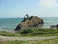
In Port Orford, you can find Battle Rock, a famous site where a battle took place between local natives and explorers in 1851. Visitors can climb Battle Rock, but it's discouraged to protect the eroding sandstone. Also in Port Orford is the Port Orford Heads State Park, which was the original Coast Guard lifeboat station. It's now a museum about maritime history.
Oregon is unique because it was the only U.S. state (excluding Hawaii and Alaska, which became states later) to experience hostile attacks during World War II.
- The first attack happened on June 21, 1942, when a Japanese submarine I-25 fired 17 rounds at Fort Stevens. The fort was not damaged.
- The second attack was on September 9, 1942. The I-25 launched a small "Glen" seaplane that dropped incendiary bombs in the forests at Mount Emily near Brookings, hoping to start large forest fires. The fires didn't spread as intended, but the bombing site is now a historic place. The pilot, Nobuo Fujita, returned to Brookings in 1962 and gave his family's 400-year-old sword to the city. He was made an honorary citizen before he passed away. His sword is now in the Brookings Public Library.
Economy: How People Make a Living
The Oregon Coast is the state's top tourist spot. In the past, the economy relied heavily on natural resources like logging and fishing. However, rules placed on these industries caused them to decline. Since the late 2000s, tourism and people retiring to the coast have helped the economy grow. About 210,000 people live on the Oregon Coast. While natural resources are still important, the biggest sources of income now come from retirement funds and tourism. The average income per person on the coast is lower than the state average.
Images for kids
-
Roads End State Recreation Site, Lincoln City
-

Viewing tunnel at Oregon Coast Aquarium
-
Remains of the Peter Iredale
-
Tillamook Rock Light A.K.A. Terrible Tilly
-
Battle Rock, Port Orford
-
Beach and estuary at Yachats
-
Devil's Churn, near Cape Perpetua, south of Yachats
-
Dusk at Cannon Beach
.jpg)


