
Coos Bay, Oregon facts for kids
Quick facts for kids
Coos Bay, Oregon
|
|
|---|---|

The Tioga Building in July 2021
|
|
| Nickname(s):
Oregon's Bay Area
|
|

Location in Oregon
|
|
| Country | United States |
| State | Oregon |
| County | Coos |
| Named for | Coos Bay |
| Area | |
| • City | 15.90 sq mi (41.19 km2) |
| • Land | 10.63 sq mi (27.53 km2) |
| • Water | 5.28 sq mi (13.66 km2) |
| • Urban | 27.71 sq mi (71.8 km2) |
| • Metro | 1,806.22 sq mi (4,678.1 km2) |
| Elevation | 138 ft (42 m) |
| Population
(2020)
|
|
| • City | 15,985 |
| • Density | 1,503.90/sq mi (580.67/km2) |
| • Urban | 31,995 |
| • Metro | 64,620 |
| Time zone | UTC−8 (Pacific) |
| • Summer (DST) | UTC−7 (Pacific) |
| ZIP code |
97420
|
| Area code(s) | 458 and 541 |
| FIPS code | 41-15250 |
| GNIS feature ID | 2410223 |
| Website | www.coosbayor.gov |
_(cooD0088).jpg)
Coos Bay is a city in Coos County, Oregon, United States. It sits where the Coos River meets Coos Bay and the Pacific Ocean. The city is next to North Bend. People often call them "Coos Bay-North Bend" or "Oregon's Bay Area." In 2020, Coos Bay had 15,985 residents. This makes it the biggest city on the Oregon Coast. The wider "Oregon's Bay Area" has about 32,308 people.
Contents
History of Coos Bay
For thousands of years, Native American tribes lived in the Coos Bay area. The Coos, Lower Umpqua, Siuslaw, and Coquille tribes fished, hunted, and gathered food here. About 400 years ago, British and Spanish explorers first visited the South Coast. In 1579, Sir Francis Drake may have found shelter for his ship, the Golden Hinde, near Cape Arago. Later, fur trader Jedediah Smith explored the area.
How Coos Bay Started
The first European Americans settled here in January 1852. They were survivors of a shipwreck. They set up Camp Castaway until they could be rescued. A permanent town called Marshfield was founded in 1853. It was named after the Massachusetts hometown of its founder, J. C. Tolman. The first church was built in 1857.
By 1866, people who worked on the sea built the Cape Arago Light. A post office opened in 1871. In 1872, the Coos Bay Wagon Road connected Coos County to the Umpqua River valley. This road helped link the area to other parts of Oregon. Today, parts of Oregon Route 42 follow this old road.
In 1874, Marshfield officially became a city. One of the oldest machine shops in the country, Nelson Machine Works-Coos Bay Iron Works, started in 1888. It is still open today.
Changes in the 20th Century

Before 1915, the Coos region was hard to reach from the rest of Oregon. Traveling by sea to San Francisco was easier than going over the mountains. In 1916, a train line was finished. This connected the area to inland towns. It helped trade and tourism grow. The city grew a lot in the 1920s, and even more from the 1930s to 1950s.
In 1944, residents voted to change the city's name from Marshfield to Coos Bay. This made the city's name match the bay it sits on.
On February 4, 1999, a Japanese ship called the New Carissa got stuck on a beach near Coos Bay. The ship was empty and was coming to pick up wood chips. Bad weather kept it from entering the port. The ship spilled 70,000 gallons of fuel oil. More oil was burned off to prevent further spills. The back part of the ship stayed on the beach for years. It was finally cut up and removed in 2008.
In 2002, a sad event happened when three firefighters died in a building fire. This was a very difficult time for the city.
Geography of Coos Bay

Coos Bay covers about 15.90 square miles (41.19 km2). About 10.60 square miles (27.53 km2) is land, and 5.30 square miles (13.66 km2) is water. The city has many hills, with heights from sea level to over 500 feet (150 m). Lakes and streams in the city include Upper Pony Creek Reservoir, Lake Merritt, and Empire Lakes.
City Areas and Neighborhoods

_(cooDA0013a).jpg)
- Marshfield District: This is the old downtown and business area. It was the original Coos Bay before other areas joined it. It has many historic buildings, like the Carnegie Library and the Egyptian Theatre. The waterfront has a boardwalk, a city dock, and trails.
- Milner Crest: This is a neighborhood built in the mid-20th century. It sits on a hill overlooking the bay. Most of Coos Bay's medical facilities are here.
- Eastside: This area was once called East Marshfield. It joined Coos Bay in 1983. Eastside is mostly homes. It has Millicoma Middle School and walking trails at Millicoma Marsh.
- Empire: This area was founded as Empire City in 1853. For a while, it was the county seat of Coos County. Empire became part of Coos Bay in 1965. Today, it has Madison Elementary School and Sunset Intermediate School.
Climate in Coos Bay
Coos Bay has warm, dry summers. The weather is usually mild, with temperatures from the low 40s to upper 60s Fahrenheit (around 4-20 degrees Celsius). The highest temperature ever recorded was 102 °F (39 °C) in September 2009. The lowest was 0 °F (-18 °C) in December 1990.
| Climate data for Coos Bay, Oregon | |||||||||||||
|---|---|---|---|---|---|---|---|---|---|---|---|---|---|
| Month | Jan | Feb | Mar | Apr | May | Jun | Jul | Aug | Sep | Oct | Nov | Dec | Year |
| Record high °F (°C) | 74 (23) |
82 (28) |
88 (31) |
88 (31) |
94 (34) |
92 (33) |
96 (36) |
91 (33) |
102 (39) |
95 (35) |
76 (24) |
70 (21) |
102 (39) |
| Mean daily maximum °F (°C) | 53 (12) |
55 (13) |
55 (13) |
57 (14) |
61 (16) |
64 (18) |
67 (19) |
68 (20) |
68 (20) |
63 (17) |
57 (14) |
53 (12) |
60 (16) |
| Mean daily minimum °F (°C) | 39 (4) |
41 (5) |
41 (5) |
43 (6) |
47 (8) |
50 (10) |
53 (12) |
53 (12) |
50 (10) |
46 (8) |
43 (6) |
39 (4) |
45 (7) |
| Record low °F (°C) | 17 (−8) |
14 (−10) |
27 (−3) |
28 (−2) |
33 (1) |
22 (−6) |
39 (4) |
34 (1) |
34 (1) |
28 (−2) |
20 (−7) |
0 (−18) |
0 (−18) |
| Average precipitation inches (mm) | 9.54 (242) |
8.12 (206) |
7.94 (202) |
5.19 (132) |
3.40 (86) |
1.72 (44) |
0.51 (13) |
0.88 (22) |
1.73 (44) |
4.62 (117) |
10.36 (263) |
10.42 (265) |
64.43 (1,636) |
| Average snowfall inches (cm) | 0.20 (0.51) |
0.20 (0.51) |
0.10 (0.25) |
0 (0) |
0 (0) |
0 (0) |
0 (0) |
0 (0) |
0 (0) |
0 (0) |
0.10 (0.25) |
0.20 (0.51) |
0.80 (2.0) |
| Source: http://www.intellicast.com/Local/History.aspx?location=USOR0072 | |||||||||||||
People in Coos Bay
| Historical population | |||
|---|---|---|---|
| Census | Pop. | %± | |
| 1870 | 250 | — | |
| 1880 | 642 | 156.8% | |
| 1890 | 1,461 | 127.6% | |
| 1900 | 1,391 | −4.8% | |
| 1910 | 2,930 | 110.6% | |
| 1920 | 4,034 | 37.7% | |
| 1930 | 5,287 | 31.1% | |
| 1940 | 5,259 | −0.5% | |
| 1950 | 6,223 | 18.3% | |
| 1960 | 7,084 | 13.8% | |
| 1970 | 13,466 | 90.1% | |
| 1980 | 14,424 | 7.1% | |
| 1990 | 15,076 | 4.5% | |
| 2000 | 15,374 | 2.0% | |
| 2010 | 15,967 | 3.9% | |
| 2020 | 15,985 | 0.1% | |
| source: | |||
In 2010, Coos Bay had 15,967 people living there. Most people (87.1%) were White. About 2.6% were Native American, and 1.4% were Asian. About 4.49% of the population was Hispanic or Latino.
The average age in Coos Bay was 41.6 years old. About 20.3% of the people were under 18.
Fun Things to Do in Coos Bay
Museums and Attractions
_(cooDA0010).jpg)
- Coos Art Museum: This museum in Downtown Coos Bay opened in 1950. It has art exhibits, classes, and community events. It has 477 permanent art pieces.
- Coos Historical & Maritime Center: This museum opened in 2015 on the waterfront. It tells the story of Coos Bay's history and its connection to the sea.
- Coos Bay Iron Works: This company makes logging equipment. It opened in 1882 and still uses old tools from the Industrial Revolution.
- Egyptian Theatre: Built in 1925, this theater is famous for its Egyptian style. It's the only movie house in Oregon with its original theater organ. After closing a few times, it reopened in 2014.
- Oregon Coast Music Festival: This is an annual music festival held in July. It features local and international artists playing different types of music.
- Blackberry Arts Festival: Held every August, this festival shows off local art, crafts, food, and entertainment in the historic Marshfield District.
Parks and Outdoor Fun
_(cooDA0031).jpg)

- Mingus Park: Near downtown Coos Bay, this park has a 1-mile (1.6 km) walking path around a pond with ducks and geese. It has a swimming pool in summer, an outdoor stage, and an 18-hole disc golf course. There's also a skatepark, tennis courts, playgrounds, and a softball field.
- John Topits Park: Also called Empire Lakes, this 120-acre (49 ha) park is in northwest Coos Bay. It has lakes and protected forest land. You can use canoes and kayaks, but no motor boats. There are 5.5 miles (8.9 km) of trails for walking and biking. The lakes have many fish and birds.
The Coos Bay area has lots of outdoor activities. The Oregon Dunes National Recreation Area brings many visitors each year. The ocean beaches near Coos Bay are mostly natural. Many are state and county parks. These include Bastendorf Beach County Park, Yoakam Point State Park, Sunset Bay State Park, Shore Acres State Park, and Cape Arago State Park. The South Slough National Estuarine Research Reserve is about 11 miles (18 km) southwest. The Golden and Silver Falls State Natural Area is about 25 miles (40 km) east.


Education in Coos Bay
Public Schools

The Coos Bay School District provides K–12 public education in Coos Bay.
Colleges and Universities
- Southwestern Oregon Community College (SWOCC): This college offers certificates and associate degrees. It also has programs that help students transfer to Oregon public universities.
- Oregon Institute of Marine Biology (OIMB): This is a marine research station for the University of Oregon. It is in Charleston, near the mouth of Coos Bay.
Transportation in Coos Bay
Coos Bay is located along U.S. Highway 101.
Air Travel

The Southwest Oregon Regional Airport (KOTH) is in nearby North Bend. It is the 5th busiest airport in Oregon and the largest on the Oregon Coast. It offers daily flights to San Francisco and seasonal flights to Denver.
Bus Services
- Porter Stage Lines: This company provides bus service from Coos Bay to places like Eugene. In Eugene, you can connect to Amtrak trains and the Greyhound bus network.
- Coos Transit (CCAT): This local bus service runs daily loops to 54 stops around Coos Bay and North Bend.
Port and Rail
The Port of Coos Bay handles freight shipping. The Coos Bay Rail Link connects the port to the national train network.
Famous People from Coos Bay
Many notable people have connections to Coos Bay:
- Mel Counts: A professional basketball player who won an Olympic gold medal in 1964.
- Rich Fellers: An Olympic equestrian (horse rider).
- Mark Helfrich: A former head coach for the University of Oregon football team.
- Steve Prefontaine: A famous Olympic distance runner. He was born in Coos Bay and went to Marshfield High School.
- Jeff Whitty: A Tony Award-winning playwright.
- Wild Thang: The winner of the 2024 world's ugliest dog competition.
Sister City
Coos Bay has one sister city:
 Chōshi, Chiba Prefecture, Japan
Images for kids
-
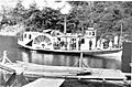
Steamboat Coos, sometime before 1895, probably in or near Coos Bay, Oregon

See also
 In Spanish: Coos Bay (Oregón) para niños
