
Coos County, Oregon facts for kids
Quick facts for kids
Coos County
|
|
|---|---|

|
|

Location within the U.S. state of Oregon
|
|
 Oregon's location within the U.S. |
|
| Country | |
| State | |
| Founded | December 22, 1853 |
| Named for | Coos people |
| Seat | Coquille |
| Largest city | Coos Bay |
| Area | |
| • Total | 1,806 sq mi (4,680 km2) |
| • Land | 1,596 sq mi (4,130 km2) |
| • Water | 210 sq mi (500 km2) 12% |
| Population
(2020)
|
|
| • Total | 64,929 |
| • Estimate
(2023)
|
64,212 |
| • Density | 35.952/sq mi (13.881/km2) |
| Time zone | UTC−8 (Pacific) |
| • Summer (DST) | UTC−7 (PDT) |
| Congressional district | 4th |
Coos County is one of the 36 counties in the U.S. state of Oregon. In 2020, about 64,929 people lived here. The main town, or county seat, is Coquille.
The county was created from parts of Umpqua and Jackson counties. It is named after a group of Native Americans called the Coos people. They have lived in this area for a very long time. Coos County is also home to the Coos Bay area, which is a busy place.
Contents
History of Coos County
Coos Bay is the original home of two Native American groups: the Miluk and Hanis people. Today, they are often called "Coos" people. Early explorers like Lewis and Clark wrote about the "Cook-koo-oose" people of Coos Bay. The name "Coos" likely comes from their notes and the local Native languages. In these languages, the area was called kuukwis. Old maps show the name spelled in many ways, like Kowes, Cowes, Coose, and Koos.
Even though people explored and trapped animals here as early as 1828, the first European-American town was built in 1853. It was called Empire City and was started by the Coos Bay Company. Today, Empire City is part of the city of Coos Bay.
Coos County was officially created on December 22, 1853. This was done by the government of the Oregon Territory. It was made from parts of Umpqua and Jackson counties. Later, in 1855, Curry County, Oregon was formed from the southern part of Coos County.
The county seat, or main government town, was first in Empire City. But in 1895, people in the county voted to choose a new county seat. In 1896, they decided to move it to Coquille, where it is today.
Geography of Coos County
Coos County covers about 1,806 square miles. Most of this area, about 1,596 square miles, is land. The rest, about 210 square miles, is water.
Neighboring Counties
- Douglas County - to the north and east
- Curry County - to the south
Protected Natural Areas
Coos County is home to parts of several important natural areas:
- Bandon Marsh National Wildlife Refuge
- Oregon Islands National Wildlife Refuge (part)
- Siskiyou National Forest (part)
- Siuslaw National Forest (part)
People of Coos County
In 2010, there were 63,043 people living in Coos County. Most people, about 89.8%, were white. About 2.5% were Native American, and 1.0% were Asian. People from Hispanic or Latino backgrounds made up 5.4% of the population. Many families in the county have German, English, or Irish roots.
The average age of people in Coos County was about 47 years old. The average income for a family was around $46,569 per year. About 16.4% of all people in the county lived below the poverty line. This included about 21.4% of children under 18.
Towns and Communities
Coos County has several towns and smaller communities.
Cities
- Bandon
- Coos Bay
- Coquille (the county seat)
- Lakeside
- Myrtle Point
- North Bend
- Powers
Census-Designated Places
These are areas that are like towns but are not officially incorporated as cities.
- Barview
- Bunker Hill
- Glasgow
- Saunders Lake
Other Communities
Economy of Coos County

In the past, people came to Coos County looking for gold. Later, between 1890 and 1910, a lot of coal was mined here. This coal was sent to California. But after oil was found in California, less coal was needed. No coal mines have been active in Coos County since 1950. People have also looked for natural gas in these coal areas since 1938.
A big project to build a 60-mile natural gas pipeline was started in 1999. This pipeline connects Roseburg to Coos Bay. It was hoped to bring new businesses to the Coos Bay area. The pipeline was finished in 2004.
Today, the main parts of Coos County's economy are:
- Forest products: This means things made from trees, like lumber.
- Tourism: Many visitors come to see the beautiful area.
- Fishing: Catching fish and other seafood is important.
- Agriculture: Farming, especially growing cranberries, is a key part of the economy.
The Bandon Dunes Golf Resort, located near Bandon, brings golfers and tourists from all over the world. Other important activities include boating, dairy farming, making products from myrtlewood, and building and fixing ships. There are also deposits of iron ore and lead that could be developed in the future.
A large energy project called the Jordan Cove Energy Project was planned. However, many local people, including farmers and Native American groups, did not want their land to be used for it. The project was stopped in late 2021.
Another project by Oregon Resources Corporation (ORC) is currently underway. This company uses modern methods to dig up local sands. They extract valuable minerals like chromite, zircon, and garnet. After they take the minerals, they put the sand back and replant trees. This project is expected to create 70 to 80 jobs for local people.
Coos County has several important port districts. These include the Port of Coos Bay (started in 1909), the Port of Coquille River (1912), and the Port of Bandon (1913). Coos Bay is known as one of the best natural harbors between San Francisco and Puget Sound. For a long time, the Port of Coos Bay was the biggest shipper of forest products in the world.
Natural Wonders
Coos County is home to the tallest living Douglas-fir tree ever recorded. It is located about 35 miles southeast of Coos Bay, near the Sitkum area. This amazing tree is more than 100 meters (about 328 feet) tall!
Images for kids
-
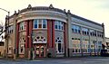
Historic Coos Bay National Bank Building.
-
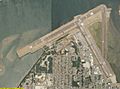
The Southwest Oregon Regional Airport in North Bend.
See also
 In Spanish: Condado de Coos para niños
