North Bend, Oregon facts for kids
Quick facts for kids
North Bend, Oregon
|
||
|---|---|---|
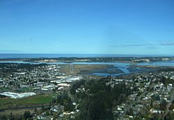
North Bend from above, looking toward the Pacific Ocean
|
||
|
||
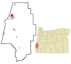
Location in Oregon
|
||
| Country | United States | |
| State | Oregon | |
| County | Coos | |
| Incorporated | 1903 | |
| Area | ||
| • City | 5.09 sq mi (13.19 km2) | |
| • Land | 3.93 sq mi (10.18 km2) | |
| • Water | 1.16 sq mi (3.01 km2) | |
| Elevation | 13 ft (4 m) | |
| Population
(2020)
|
||
| • City | 10,317 | |
| • Density | 2,623.86/sq mi (1,013.01/km2) | |
| • Urban | 31,995 | |
| Time zone | UTC−8 (Pacific) | |
| • Summer (DST) | UTC−7 (Pacific) | |
| ZIP code |
97459
|
|
| Area code(s) | 541 | |
| FIPS code | 41-53000 | |
| GNIS feature ID | 2411269 | |
| Website | northbendoregon.us | |
North Bend is a city in Coos County, Oregon, United States. In 2020, about 10,317 people lived there. The city is mostly surrounded by Coos Bay. This is an S-shaped water area where the Coos River flows into the Pacific Ocean. North Bend also shares a border with the city of Coos Bay to its south. North Bend officially became a city in 1903.
Contents
History of North Bend
Before Europeans arrived, Native American tribes lived in the Coos Bay area for thousands of years. The Coos, Lower Umpqua, Siuslaw, and Coquille tribes called this place home. They fished, hunted, and gathered food along Coos Bay, its rivers, and in the forests.
About 400 years ago, British and Spanish explorers first came to the Oregon coast. In 1579, it's believed that Sir Francis Drake found shelter for his ship, the Golden Hind, near Cape Arago. Later, explorer Jedediah Smith visited the area looking for animal furs. The Hudson's Bay Company also sent Alexander Roderick McLeod to find a way through the land.
In 1852, a ship called the Captain Lincoln got stuck on the North Spit. The people who survived set up camp and were later rescued. This event drew attention to the area, and gold miners came to search for gold on the beaches. In 1853, the Coos Bay Commercial Company arrived from the Rogue Valley. They helped create paths for new settlers.
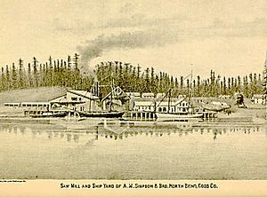
A man named Thomas Symons started a settlement called Yarrow in 1863. In 1902, Louis Simpson bought Yarrow. The next year, in 1903, Simpson combined Yarrow with his father's sawmill site, Old Town. He named this new combined area North Bend.
Empire City was another important settlement and was the county's main town until 1896. People were drawn to the area because of its rich natural resources. Sawmills and shipyards in Old Town North Bend and Empire City helped the economy grow. They also attracted many workers. Rivers and sloughs (small waterways) were used to move people and goods like timber, farm products, and coal. Towns became centers for travel further inland. Early industries included cutting timber, building ships, farming, mining coal, and canning salmon.
Before about 1915, the Coos region was quite cut off from the rest of Oregon. It was hard to cross the Coast Range mountains and rivers. So, people used the Pacific Ocean to connect with other places, like San Francisco. A trip by sea was easier and faster than traveling over the rough land. In 1916, trains finally linked the region to other towns inland. This helped increase trade and tourism.
North Bend grew a lot in the 1920s. Even more growth happened from the 1930s to the 1950s. During this time, shipyards built minesweepers (ships that clear mines) and rescue tugs for World War II. Large timber companies also started and grew their businesses. Improvements to the jetties (structures that protect harbors) and more commercial fishing helped develop Charleston.
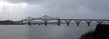
A big change came with the completion of the North Bend Bridge in 1936. This bridge is now called the Conde McCullough Memorial Bridge. The Roosevelt Highway also greatly improved travel. These links finally connected the Coos region to the outside world. The area, once far away, had now become a major place.
During a difficult time in the 1930s, the only bank in North Bend had to close temporarily. This caused a money problem for the city. North Bend found a creative solution: they made their own money! They used myrtlewood discs and printed them at a newspaper press. These wooden coins came in values from 25 cents to $10. The city used them to pay workers and promised to exchange them for regular money later.
When the bank reopened, the city asked people to bring back their myrtlewood money. But many people decided to keep the wooden coins as collector's items. The city eventually gave up trying to get them back. They announced that the wooden tokens would always be legal money in North Bend. People still exchanged them sometimes until the 1960s. Today, the remaining myrtlewood coins are very valuable because they are rare and have a special history. It's believed that fewer than 10 complete sets still exist.
Geography and Climate
North Bend covers about 5.09 square miles (13.19 square kilometers). About 3.92 square miles (10.18 square kilometers) is land, and 1.17 square miles (3.01 square kilometers) is water.
North Bend's Climate
The weather in North Bend is very humid. It's like a Mediterranean climate but with dry summers, or an oceanic climate with dry summers. The temperature doesn't change much throughout the year. The average monthly temperatures range from about 46.4°F (8°C) in December to 60.1°F (15.6°C) in August. Sometimes, very cold or hot air can come in. The coldest temperature ever recorded was 17°F (-8°C) in 1990. The hottest was 96°F (36°C) in 1925.
Cool breezes from the Pacific Ocean keep the city's weather mild all year. It rains a lot in winter because of moist air from the Pacific. The city gets about 64.7 inches (164 cm) of rain each year. However, July and August usually get less than an inch of rain. Fog often covers the coast in summer. This happens because the cool ocean air meets the warmer air inland. This keeps temperatures cooler than in places like Eugene or Seattle. Snow almost never falls in the city itself. But it can snow a lot in the nearby Oregon Coast Range mountains.
Cape Blanco, which is nearby, is one of the windiest places on Earth. Winds there can reach 125 mph (201 km/h) or more during strong winter storms. Each year, North Bend has about 25 days where the temperature doesn't reach 50°F (10°C). It only has about 12 days where the temperature is at or below freezing.
North Bend is considered the northernmost place in North America with a subtropical climate. This is based on recent temperature data. This is interesting because it's further north than Milwaukee, Wisconsin. Now, eight months of the year have an average temperature above 50°F (10°C).
| Climate data for North Bend, Oregon (1991–2020 normals, extremes 1902–present) | |||||||||||||
|---|---|---|---|---|---|---|---|---|---|---|---|---|---|
| Month | Jan | Feb | Mar | Apr | May | Jun | Jul | Aug | Sep | Oct | Nov | Dec | Year |
| Record high °F (°C) | 74 (23) |
82 (28) |
86 (30) |
88 (31) |
95 (35) |
100 (38) |
98 (37) |
96 (36) |
94 (34) |
95 (35) |
78 (26) |
70 (21) |
100 (38) |
| Mean maximum °F (°C) | 64.6 (18.1) |
65.5 (18.6) |
66.9 (19.4) |
69.3 (20.7) |
71.3 (21.8) |
71.6 (22.0) |
72.5 (22.5) |
76.0 (24.4) |
79.7 (26.5) |
76.4 (24.7) |
67.2 (19.6) |
62.9 (17.2) |
84.5 (29.2) |
| Mean daily maximum °F (°C) | 53.5 (11.9) |
54.1 (12.3) |
55.1 (12.8) |
56.7 (13.7) |
60.5 (15.8) |
63.5 (17.5) |
66.1 (18.9) |
67.3 (19.6) |
66.7 (19.3) |
62.8 (17.1) |
56.8 (13.8) |
52.9 (11.6) |
59.7 (15.4) |
| Daily mean °F (°C) | 47.3 (8.5) |
47.6 (8.7) |
48.5 (9.2) |
50.4 (10.2) |
54.2 (12.3) |
57.4 (14.1) |
59.8 (15.4) |
60.4 (15.8) |
59.0 (15.0) |
54.9 (12.7) |
50.2 (10.1) |
46.7 (8.2) |
53.0 (11.7) |
| Mean daily minimum °F (°C) | 41.0 (5.0) |
41.0 (5.0) |
41.9 (5.5) |
44.0 (6.7) |
48.0 (8.9) |
51.2 (10.7) |
53.6 (12.0) |
53.6 (12.0) |
51.3 (10.7) |
47.0 (8.3) |
43.5 (6.4) |
40.4 (4.7) |
46.4 (8.0) |
| Mean minimum °F (°C) | 31.2 (−0.4) |
31.2 (−0.4) |
33.3 (0.7) |
35.7 (2.1) |
38.7 (3.7) |
44.0 (6.7) |
47.5 (8.6) |
46.9 (8.3) |
43.7 (6.5) |
37.9 (3.3) |
32.8 (0.4) |
30.5 (−0.8) |
27.4 (−2.6) |
| Record low °F (°C) | 16 (−9) |
14 (−10) |
18 (−8) |
27 (−3) |
26 (−3) |
33 (1) |
35 (2) |
35 (2) |
30 (−1) |
26 (−3) |
20 (−7) |
13 (−11) |
13 (−11) |
| Average precipitation inches (mm) | 9.43 (240) |
6.99 (178) |
7.49 (190) |
5.40 (137) |
2.95 (75) |
1.55 (39) |
0.35 (8.9) |
0.42 (11) |
1.55 (39) |
4.24 (108) |
8.30 (211) |
10.47 (266) |
59.14 (1,502) |
| Average snowfall inches (cm) | 0.0 (0.0) |
0.0 (0.0) |
0.0 (0.0) |
0.0 (0.0) |
0.0 (0.0) |
0.0 (0.0) |
0.0 (0.0) |
0.0 (0.0) |
0.0 (0.0) |
0.0 (0.0) |
0.0 (0.0) |
0.2 (0.51) |
0.2 (0.51) |
| Average precipitation days (≥ 0.01 inch) | 19.2 | 17.5 | 19.0 | 17.3 | 12.4 | 9.1 | 3.3 | 4.2 | 5.8 | 12.8 | 18.9 | 19.6 | 159.1 |
| Average snowy days (≥ 0.1 in) | 0.2 | 0.1 | 0.1 | 0.0 | 0.0 | 0.0 | 0.0 | 0.0 | 0.0 | 0.0 | 0.1 | 0.1 | 0.6 |
| Source: NOAA | |||||||||||||
People of North Bend (Demographics)
| Historical population | |||
|---|---|---|---|
| Census | Pop. | %± | |
| 1880 | 84 | — | |
| 1910 | 2,078 | — | |
| 1920 | 3,268 | 57.3% | |
| 1930 | 4,012 | 22.8% | |
| 1940 | 4,602 | 14.7% | |
| 1950 | 6,099 | 32.5% | |
| 1960 | 7,512 | 23.2% | |
| 1970 | 8,553 | 13.9% | |
| 1980 | 9,779 | 14.3% | |
| 1990 | 9,614 | −1.7% | |
| 2000 | 9,544 | −0.7% | |
| 2010 | 9,695 | 1.6% | |
| 2020 | 10,317 | 6.4% | |
| source: | |||
In 2010, there were 9,695 people living in North Bend. These people made up 4,113 households and 2,495 families. The city had about 2,473 people per square mile. North Bend is the second largest city in Oregon's Bay Area.
About 28.7% of households had children under 18 living with them. Many households (43.9%) were married couples. About 13.6% of households had someone living alone who was 65 or older. The average household had 2.33 people. The average family had 2.87 people.
The average age of people in the city was 41.3 years old. About 21.9% of residents were under 18. And 17.6% were 65 years or older. The city had slightly more females (52.4%) than males (47.6%).
Arts and Culture
North Bend has a public boat ramp where you can access Coos Bay. There's also a concrete pier and a boardwalk area that was finished in 2010. The city also has a public indoor pool that is Olympic-sized.
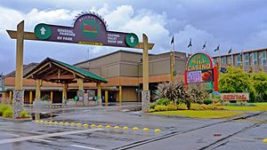
If you like shopping, the Pony Village Mall in North Bend is an indoor shopping center. For entertainment, The Mill Casino is a Native American gaming center. It has a hotel, games, and restaurants.
You can also see Oregon's freight wagon from the Merci Train in Simpson Park. This wagon is kept safe in a special enclosure.
Education
The North Bend School District provides public education for students from kindergarten through 12th grade.
Media
Radio Stations
- KTEE 94.9 FM (commercial radio)
- KOOS 107.3 FM (commercial radio)
- KBBR 1340 AM (commercial radio)
- KMHS 1420 AM (high school radio)
Notable People
- Louis J. Simpson (1877–1949) – He was important in shipping and timber businesses.
Transportation
Air Travel
The Southwest Oregon Regional Airport is near North Bend and Coos Bay. It is the only commercial airport on the Oregon Coast.
Roads
The Conde McCullough Memorial Bridge is located in North Bend. This bridge carries U.S. Route 101. This major highway runs all the way from Tumwater, Washington to Los Angeles, California.
Rail Travel
The city is served by the Coos Bay Rail Line. This train line carries freight (goods) only. It runs from Coquille to Eugene. The Port of Coos Bay owns this rail line.
See also
 In Spanish: North Bend (Oregón) para niños
 | Isaac Myers |
 | D. Hamilton Jackson |
 | A. Philip Randolph |


