
Cape Blanco (Oregon) facts for kids
Quick facts for kids Cape Blanco State Park |
|
|---|---|

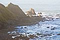
View from Cape Blanco, looking south towards Port Orford Heads State Park. Humbug Mountain in the distance.
|
|
| Lua error in Module:Location_map at line 420: attempt to index field 'wikibase' (a nil value). | |
| Type | Public, state |
| Location | Curry County, Oregon |
| Nearest city | Port Orford |
| Area | 1,880 acres (760 ha) |
| Operated by | Oregon Parks and Recreation Department |
| Visitors | Annually, about 350,000 for day-use, 35,000 overnight |
| Open | Year-round |

Cape Blanco is a famous piece of land that sticks out into the Pacific Ocean in southwestern Oregon, USA. It's the westernmost point in the entire state! It reaches further west than almost any other spot in the lower 48 states. Only parts of the Olympic Peninsula in Washington, like Cape Alava, go even further west.
This cape is part of the beautiful Cape Blanco State Park. It's also home to the Cape Blanco Light, a lighthouse that first shone its light in 1870.
The name "Cape Blanco" might have come from an explorer named Martín de Aguilar in 1603. Blanco means "white" in Spanish, perhaps because of how the cape looked. Later, in 1775, Juan Francisco de la Bodega y Quadra called it Cabo Diligensias. Captain George Vancouver renamed it Cape Orford in 1792, but the name Cape Blanco eventually became the one everyone used.
Contents
What is Cape Blanco?
The cape is a fairly flat area of land with tall cliffs facing the sea. It rises about 200 feet (61 m) above the ocean.
How the Land Was Formed
Cape Blanco is made of layers of old ocean dirt and rocks that have been pushed up. The oldest layers are about 80 million years old, and the newest are less than 500,000 years old. This area is still rising by a few millimeters each year! This happens because the ocean floor is slowly sliding under the continent.
Nearby Landforms
Around the cape, you can see beaches, cliffs, and rocky reefs. If you look south, you'll spot Needle Rock, Blanco Reef, and Humbug Mountain. To the north, there's Gull Rock, Castle Rock, and Blacklock Point. Blanco Reef is a group of jagged rocks and ledges that are about 2 to 5 miles (3 to 8 km) offshore. Some of these rocks are as tall as 149 feet (45 m)!
Where is Cape Blanco and What's the Weather Like?
Cape Blanco is in the northern part of Curry County. It's about 4 miles (6 km) north of Port Orford. This part of the coast is mountainous and quite isolated. It's bordered to the east by the Coast Range. The cape is also about 5 miles (8 km) west of U.S. Route 101.
The Sixes River flows into the Pacific Ocean on the north side of the cape. You can take a 2-mile (3 km) walk along the Oregon Coast Trail from the park. This trail leads south to where the Elk River meets the ocean.
Cape Blanco's Climate
Cape Blanco has very mild temperatures all year round. The highest temperature ever recorded there was only 85 °F (29.4 °C). It gets a lot of rain each year, but summers are much drier. This type of weather is called a warm-summer Mediterranean climate.
During winter storms, winds at the cape can be super strong, reaching 70 to 100 miles per hour (113 to 161 km/h)! These extreme winds, especially over the Blanco Reef, make this part of the coast very dangerous for ships.
Fun Things to Do at Cape Blanco State Park
There are many fun activities at Cape Blanco State Park! You can go hiking, horseback riding, fishing, camping, or picnicking. Beachcombing is also popular, where you can search for treasures along the shore.
You can also visit the historic lighthouse, a pioneer cemetery, or the Hughes House. The Hughes House is listed on the National Register of Historic Places.
The Hughes House History
The land where the park is now originally belonged to Patrick Hughes. He came to the cape in 1860 looking for gold. He ended up starting a 2,000-acre (810 ha) dairy farm along the lower Sixes River. The Hughes House is a two-story house with eleven rooms. It was finished in 1898. A group called the "Friends of Cape Blanco" helped restore it.
Cape Blanco in Books
Cape Blanco has even appeared in some famous books!
In Jules Verne's early science fiction book The Begum's Millions, a perfect community called Ville-France is set up in 1872. Verne says this made-up town is "eighty kilometres north of Cape Blanco."
Cape Blanco is also shown on a map of Brobdingnag in Gulliver's Travels. And it's mentioned in Chapter 3 of Moby-Dick. The book says: "And that harpoon-so like a corkscrew now-was flung in Javan seas, and run away with by a whale, years afterwards slain off the Cape of Blanco."
Gallery
-
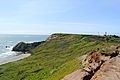
North side of the Cape
-
Cape Blanco and lighthouse
-
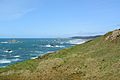
Cape Blanco looking north towards Gulf Rock, Castle Rock and Floras Lake State Park


See also
 In Spanish: Cabo Blanco (Oregón) para niños
