Elk River (Oregon) facts for kids
Quick facts for kids Elk River |
|
|---|---|

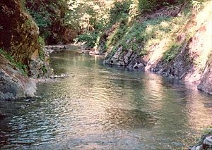
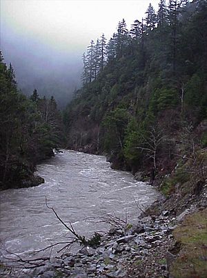
Elk River flowing through the forest
|
|
|
Location of the mouth of Elk River in Oregon
|
|
| Country | United States |
| State | Oregon |
| County | Curry |
| Physical characteristics | |
| Main source | confluence of North Fork Elk River and South Fork Elk River Rogue River – Siskiyou National Forest 913 ft (278 m) 42°43′00″N 124°12′19″W / 42.71667°N 124.20528°W |
| River mouth | Pacific Ocean between Cape Blanco and Port Orford 3 ft (0.91 m) 42°47′35″N 124°31′32″W / 42.79306°N 124.52556°W |
| Length | 29 mi (47 km) |
| Depth |
|
| Basin features | |
| Basin size | 92 sq mi (240 km2) |
| Type: | Wild, Scenic, Recreational |
| Designated: | October 28, 1988 |
The Elk River is a beautiful river located in southwestern Oregon, United States. It flows for about 29 miles (47 km) (about 47 kilometers). This river helps drain a large area of the Coast Range mountains, which is about 92-square-mile (240 km2) (238 square kilometers) in size. Finally, it empties into the mighty Pacific Ocean.
The Elk River starts high up in the mountains of northern Curry County. It begins where its North Fork and South Fork meet in the Siskiyou National Forest. The river first flows west, following the southern edge of the Grassy Knob Wilderness. Then, it turns northwest, getting closer to the coast north of Port Orford. It enters the Pacific Ocean between Cape Blanco to the north and a place called The Heads to the south.
Contents
Journey of the Elk River
From where its two main branches meet, the Elk River flows mostly west and then northwest. This journey covers about 29 miles (47 km). Most of the river, except for its last 10 miles (16 km), is inside the Rogue River – Siskiyou National Forest.
A road called Forest Road 5325 follows the river on its left side. This road later becomes County Road 208, also known as Elk Creek Road, after leaving the national forest. County Road 208 ends when it meets U.S. Route 101. This meeting point is about 3 miles (5 km) by water from where the river meets the ocean.
River's Path and Tributaries
In its early parts, the Elk River gets water from several smaller streams. McCurdy and Blackberry creeks join from the left. Bungalow Creek comes in from the right. Then, Milbury Creek adds its water from the left, about 26 miles (42 km) from the river's mouth.
A bit further downstream, Butler Creek joins from the right near Butler Bar Campground. At this point, the river becomes the southern border of the Grassy Knob Wilderness. As it continues, Lost and Panther creeks flow in from the left. Sunshine Creek enters from the right near Sunshine Bar Campground, about 19 miles (31 km) from the ocean. After this, Red Cedar and Slate creeks join from the right, and Platinum Creek comes in from the left.
The river then turns more sharply northwest. Bald Mountain Creek flows in from the left. After this, the river leaves the wilderness area and reaches the Elk River State Fish Hatchery. Here, Anvil Creek joins from the right.
Below the hatchery, Chapman Creek enters from the left. The river then turns sharply north and winds along the edge of the national forest. It crosses the forest border five times, finally leaving it for good. At this point, Rock Creek joins from the right, about 10 miles (16 km) from the mouth.
About 4 miles (6 km) downstream, Bagley Creek enters from the left, and Indian Creek joins from the right. After flowing under Route 101, the Elk River meanders across the flat coastal land. It turns north behind sand dunes before finally entering the Pacific Ocean. This happens between Cape Blanco to the north and Port Orford to the south. In the ocean near the mouth, you can find Orford Reef and part of the Oregon Islands National Wildlife Refuge.
Fun Activities on the Elk River
The Elk River area is a great place for many outdoor activities. People enjoy fishing, camping, hiking, swimming, and watching wildlife. The river and its smaller streams are home to several types of native fish. These include chinook salmon, coastal cutthroat trout, winter steelhead, and coho salmon.
Fishing and River Designations
Fishing is allowed in certain parts of the river. Within the national forest, you can fish on a 2 miles (3 km) stretch of the river below where it meets Bald Mountain Creek. Downstream from the Elk River Hatchery, about 13 miles (21 km) of the river flows past private land. This section is open for fishing from drift boats.
In 1988, parts of the Elk River and its North Fork were given a special status. They were named "Wild and Scenic" rivers as part of the National Wild and Scenic Rivers System. The lower 2 miles (3.2 km) of the North Fork are called "wild." This means they are kept very natural and untouched. A 17-mile (27 km) section of the main river, from where the North and South forks meet all the way to Anvil Creek, is called "recreational." This means it's a great place for people to enjoy outdoor activities.
Camping and Water Fun
There are three national forest campgrounds along Forest Road 5325. These are Sunshine Bar and Butler Bar, which are near the main river. Laird Lake campground is located near the South Fork. The river also has many pools that are large enough for swimming, making it a popular spot on warm days.
For those who love whitewater rafting or kayaking, there's an exciting 12.5-mile (20.1 km) stretch of the river. This section is between Butler Creek and the Elk River Hatchery. The rapids here can be challenging, ranging from class 3 to 4 on the International Scale of River Difficulty.
Protected Wilderness Area
In 2009, a large area of 13,700 acres (55.4 km2) was set aside as the Copper Salmon Wilderness. This area includes parts of the North and South forks of the Elk River, as well as the upper middle fork of the Sixes River. This wilderness is very important because it has one of the largest remaining areas of old-growth forest at low elevations. It also has some of the healthiest populations of salmon, steelhead, and cutthroat trout in the continental United States.
Many special species live in this protected region. These include the Port Orford cedar trees, marbled murrelet birds, and northern spotted owls. Protecting this area helps these important plants and animals thrive.
 | Jessica Watkins |
 | Robert Henry Lawrence Jr. |
 | Mae Jemison |
 | Sian Proctor |
 | Guion Bluford |


