U.S. Route 101 in Oregon facts for kids
Quick facts for kids
U.S. Route 101 |
||||
|---|---|---|---|---|
| Oregon Coast Highway | ||||
|
US 101 highlighted in red
|
||||
| Route information | ||||
| Maintained by ODOT | ||||
| Length | 363.11 mi (584.37 km) | |||
| Existed | November 11, 1926–present | |||
| Tourist routes |
|
|||
| Major junctions | ||||
| South end | ||||
|
||||
| North end | ||||
| Location | ||||
| Counties: | Curry, Coos, Douglas, Lane, Lincoln, Tillamook, Clatsop | |||
| Highway system | ||||
| United States Numbered Highways List • Bannered • Divided • Replaced Oregon highways
|
||||
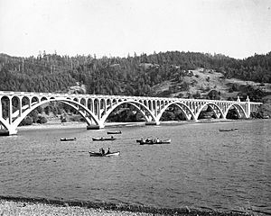
U.S. Route 101 (also called US 101) is a very important road in Oregon. It runs from north to south right along the western Oregon coastline, close to the Pacific Ocean. This highway starts at the California border, near Brookings, and goes all the way to the Washington state line. It crosses the Columbia River between Astoria, Oregon and Megler, Washington.
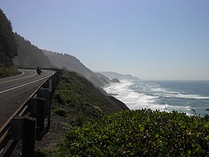
US 101 is officially known as the Oregon Coast Highway No. 9. It's the main road for the entire Oregon Coast area. A lot of the highway is built between the Pacific Ocean and the Oregon Coast Range mountains. This means it often goes up and down hills. For most of its length, it's a two-lane road with no divider.
Sometimes, parts of US 101 have to close because of landslides. These happen when there's a lot of rain. In many coastal areas, US 101 is the only way to get between towns. So, if it closes, people have to drive far inland over the Coast Range mountains to find other roads. Then they have to drive back to the coast.
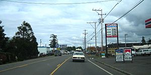
US 101 often serves as the main street in the small towns along the coast. This can cause a lot of traffic, especially in popular places like Lincoln City. The way the town is built and the many tourists can make traffic jams.
Contents
Exploring the Oregon Coast Highway
Journey from Brookings to Coos Bay
The Oregon part of US 101 starts at the border with California. This is just south of the towns of Brookings and Harbor. This section of the highway is mostly a two-lane road that follows the southern Oregon coastline. You can also reach this area using other roads like U.S. Route 199 or Oregon Route 42.
Along this part of US 101, you'll find coastal towns such as Pistol River, Gold Beach, and Port Orford. North of Port Orford is Cape Blanco. This is the westernmost point in the entire U.S. Highway system! After passing through a few more small towns, US 101 enters Bandon. This town is located at the mouth of the Coquille River. Just north of Bandon, the highway crosses the river on the Bullards Bridge.
Between Brookings and Gold Beach, you'll see the highest bridge in Oregon, called the Thomas Creek Bridge. Its road is 345 feet (105 meters) above Thomas Creek. This makes it the 15th highest bridge in the U.S.
North of Bandon, US 101 moves a bit inland. As it gets closer to Coos Bay, the highway becomes a faster road with limited access. It then goes through downtown Coos Bay and into North Bend. North of North Bend, it crosses the bay on the Conde McCullough Memorial Bridge.
From Coos Bay to Lincoln City
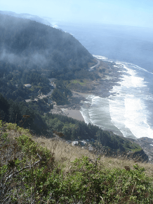
North of Coos Bay, the highway runs along the edge of the Oregon Dunes National Recreation Area. It passes through towns like Lakeside and Winchester Bay. Then it reaches Reedsport at the mouth of the Umpqua River. The highway continues north through the dunes and towns like Florence on the Siuslaw River.
The section of US 101 between Florence and Newport stays very close to the ocean. This gives drivers amazing views of the Pacific. Towns along this stretch include Yachats, Waldport, and Seal Rock. Eventually, the highway crosses the Yaquina Bay Bridge into Newport. Before the bridge, you can visit the Oregon Coast Aquarium. On the other side is Newport's famous waterfront. In Newport, US Route 20 also ends at US 101.
The next part of 101, between Newport and Lincoln City, is quite hilly. This is because the Coast Range mountains come right up to the ocean here. Towns on this route include Depoe Bay and the Gleneden Beach area, known for its resorts. Near Siletz Bay is the old, abandoned community of Kernville, before you reach Lincoln City.
From Lincoln City to Astoria
The drive through Lincoln City on US 101 is known for its heavy traffic. The city is over seven miles (11 km) long but only a few blocks wide in some places. It's squeezed between the ocean on one side and Devils Lake and mountains on the other. In many parts of town, the highway is still just two lanes. A casino in the northern part of town also adds to the traffic. Much of the traffic leaves US 101 north of Lincoln City, where it meets Oregon Route 18.
North of Lincoln City, you'll find the town of Neskowin. A special side road, the Three Capes Scenic Route, lets you visit coastal towns like Pacific City. It also goes over Cape Lookout before rejoining 101 near Tillamook. US 101 itself heads inland, passing through towns like Cloverdale and Hebo. The next big town is Tillamook.
North of Tillamook, the highway goes along the eastern side of Tillamook Bay. It passes through towns like Bay City and Garibaldi before reaching the ocean again. It then continues north along the Pacific through towns like Rockaway Beach. The next major towns are Nehalem and Manzanita, both on Nehalem Bay. The highway then goes through rough terrain until it reaches Cannon Beach. Unlike most coastal towns, Cannon Beach has a bypass road for US 101. A few miles north of Cannon Beach, US 101 meets U.S. Route 26, and then you reach Seaside.
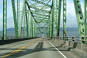
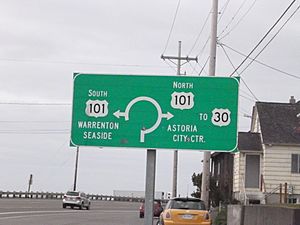
North of Seaside, US 101 follows the flat coastal land through cities like Gearhart. A side road (Oregon Route 104) leads to Fort Stevens State Park. US 101 soon enters Warrenton, Oregon. Here, a special route called Business 101 offers a scenic drive to places like the Astoria-Warrenton Airport and Fort Clatsop. Then, US 101 crosses Youngs Bay into Astoria, Oregon. It goes through the edge of Astoria until it meets U.S. Route 30. At this spot, 101 climbs onto the Astoria-Megler Bridge over the Columbia River and crosses into Washington.
History of the Oregon Coast Highway
For a long time, the Oregon Coast was quite isolated. People mostly used boats or traveled along the beaches to get between towns. In the early 1900s, plans were made to build a highway for cars. This idea became the Roosevelt Coast Military Highway. Its construction was approved in 1919. It was part of a big plan to build highways across the state, paid for by a special tax on gasoline. Building the highway started in 1921. In 1926, it became part of US 101, and in 1931, it was officially named the Oregon Coast Highway.
Originally, the highway had six places where cars had to cross major rivers and bays using ferry boats. Private companies ran these ferries until the state government bought them in 1927. The state tried to run the ferries more often, but they weren't enough for the growing number of cars. To fix this, five new bridges were built between 1934 and 1936. These bridges were designed by a state engineer named Conde B. McCullough. They were paid for by federal government programs during the New Deal. The Oregon Coast Highway was officially finished on October 3, 1936. It cost about $25 million to build.
In the 1950s and 1960s, the state government built new parts of US 101. This was part of a $30 million plan to make the highway more modern. These projects made US 101 25 miles (40 km) shorter. They rebuilt 165 miles (266 km) of the highway to better standards. For example, a new 53-mile (85 km) section from Brookings to Gold Beach opened in December 1961. This new section removed 398 curves! A direct route from Bandon to Coos Bay opened in December 1960, bypassing the town of Coquille. The old road through Coquille became OR 42. In 1964, US 101 was changed between Seaside and Astoria using a new bridge over Youngs Bay.
In 2015, the entire US 101 in Oregon was given a special name by the state government: the Persian Gulf, Afghanistan, and Iraq Veterans Memorial Highway.
|
See also
 In Spanish: U.S. Route 101 (Oregón) para niños
 | Kyle Baker |
 | Joseph Yoakum |
 | Laura Wheeler Waring |
 | Henry Ossawa Tanner |


