
Umpqua River facts for kids
Quick facts for kids Umpqua River |
|
|---|---|

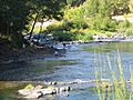
Fishing in the Umpqua River
|
|

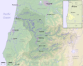
Map of the Umpqua River watershed
|
|
| Country | United States |
| State | Oregon |
| County | Douglas |
| Physical characteristics | |
| Main source | Confluence of North and South Umpqua Rivers Near Roseburg 362 ft (110 m) 43°16′05″N 123°26′46″W / 43.26806°N 123.44611°W |
| River mouth | Pacific Ocean Reedsport 0 ft (0 m) 43°40′09″N 124°12′18″W / 43.66917°N 124.20500°W |
| Length | 111 mi (179 km) |
| Basin features | |
| Basin size | 4,640 sq mi (12,000 km2) |
The Umpqua River (pronounced UMP-kwə) is a river in Oregon, United States. It flows into the Pacific Ocean on the Oregon Coast. The river is about 111 miles (179 km) long. It is one of the main rivers of the Oregon Coast. The Umpqua River is known for its bass and shad fish.
The river flows through many valleys in the mountains. These mountains are west of the Cascade Range. They are also south of the Willamette Valley. The Calapooya Mountains separate the Umpqua from the Willamette Valley. The Umpqua River starts northeast of Roseburg. It then flows northwest through the Oregon Coast Range. Finally, it empties into the Pacific Ocean at Winchester Bay.
Most of the Umpqua River and its smaller streams are in Douglas County. This county covers most of the river's watershed. The "Hundred Valleys of the Umpqua" are important for the timber industry in southern Oregon. Roseburg is the main city in this area.
Many Native American tribes lived in the Umpqua River area. These include the Lower and Upper Umpqua tribes. The river is named after them. The Kalapuya tribe also lived here. These tribes saw the Great Flood of 1862. During this flood, the Umpqua River rose to very high levels. Even the oldest people had never seen such a big flood.
Contents
Where the Umpqua River Flows
The Umpqua River starts from two main branches: the North Umpqua and the South Umpqua rivers. Both of these branches begin in the Southern Oregon Cascades mountains. They flow west for over 100 miles (160 km). They join together about 6 miles (10 km) northwest of Roseburg.
Today, people sometimes call the lower part of the South Umpqua River near Roseburg the "Umpqua Valley." The North Umpqua River gets its water from melting snow. It is a very popular place for fishing steelhead in the summer.
From Roseburg, the Umpqua River flows northwest. It goes through wide farming valleys in the Oregon Coast Range. It passes by the small town of Umpqua and the city of Elkton. At Elkton, the river turns west. It flows through a narrower canyon past Scottsburg. This is where the river starts to be affected by the ocean tides. From this point, the Umpqua River is deep enough for boats to travel on it.
The river then enters Winchester Bay on the Pacific Ocean. This is near Reedsport. The Smith River joins the Umpqua from the north near its mouth. The Umpqua River Light is a lighthouse that helps guide ships safely into the river.
The Umpqua is one of only four major rivers in Oregon that start in or east of the Cascade Range and reach the Pacific Ocean. The other rivers are the Rogue River, the Klamath River, and the Columbia River.
Smaller Streams Joining the Umpqua
Many smaller streams and creeks flow into the Umpqua River. From where it starts to its mouth, some of these are:
- North Umpqua River
- South Umpqua River
- Calapooya Creek
- Elk Creek
- Dean Creek
- Smith River
- Winchester Creek
History of the Umpqua River Area

In the early 1800s, the Upper Umpqua tribe gave up most of their land to the U.S. government. This happened with the 1854 Treaty with the Umpqua and Kalapuya. They agreed to move to a reservation in Lincoln County. They became part of the Confederated Tribes of Siletz.
Different groups of Native Americans lived in the Umpqua River valley. These included:
- The Upper Umpqua, who spoke an Athabaskan language.
- The Cow Creek Band of Umpqua, who spoke Takelman.
- The Yoncalla, a Kalapuyan people, in the north.
- The Quich (Lower Umpqua) from Scottsburg to the coast. The Quich spoke a dialect of the Siuslaw language.
During the Great Flood of 1862, the Umpqua River had the biggest flood ever known by the local Native Americans. The water was 10 to 15 feet (3 to 4.5 meters) higher than a flood in 1853. The river rose from November 3 to December 3. It went down for two days, then rose again until December 9. At Fort Umpqua, people could not travel upriver past Scottsburg. The river was filled with floating houses, barns, and other items. The Coquille River also caused a lot of damage to settlers' property. Other small rivers in the area were also greatly affected.
Fun Things to Do on the Umpqua River
The Umpqua River is a great place for fishing. People come here for fly-fishing, salmon fishing, and sturgeon fishing. It is also famous for its small-mouth bass, striped bass, and shad fish.
There are many places to camp and park RVs along the Umpqua River. Some of these spots are right by the river. They might have boat ramps, places to clean fish, and hot showers for visitors.

Images for kids
-
Fishing in the Umpqua River
-
Map of the Umpqua River watershed
See also
 In Spanish: Río Umpqua para niños
