North Umpqua River facts for kids
Quick facts for kids North Umpqua River |
|
|---|---|

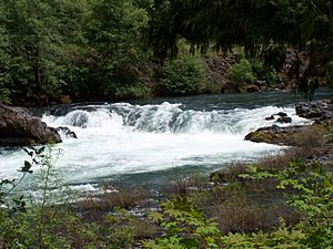
Deadline Falls on the North Umpqua River
|
|

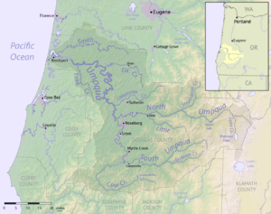
Map of the Umpqua River watershed
|
|
|
Location of the mouth of the North Umpqua River in Oregon
|
|
| Country | United States |
| State | Oregon |
| County | Douglas |
| Physical characteristics | |
| Main source | Maidu Lake Cascade Range 5,998 ft (1,828 m) 43°15′17″N 122°00′02″W / 43.25472°N 122.00056°W |
| River mouth | Confluence of the North Umpqua and South Umpqua rivers near Roseburg 361 ft (110 m) 43°16′05″N 123°26′45″W / 43.26806°N 123.44583°W |
| Length | 106 mi (171 km) |
| Basin features | |
| Basin size | 1,356 sq mi (3,510 km2) |
| Type: | Recreational |
| Designated: | October 28, 1988 |
The North Umpqua River is a beautiful river in southwestern Oregon, United States. It flows for about 106 miles (171 km) through amazing canyons and thick Douglas fir forests. People love this river for its clear, emerald green water. It's also known as one of the best places in the Pacific Northwest for fly fishing, especially for fish like salmon and steelhead that travel between fresh and salt water.
Contents
About the North Umpqua River
The North Umpqua River starts high up in the Cascade Range. Its source is Maidu Lake, which is about 5,998 feet (1,828 meters) above sea level. This lake is located near the Mount Thielsen Wilderness. The river then winds its way west, flowing along the southern side of the Calapooya Mountains.
As it flows, the river passes through the Umpqua National Forest. You can see famous spots like Toketee Falls along its path. Near Steamboat, another stream called Steamboat Creek joins it. Further downstream, near Glide, the Little River flows into it. This meeting point is known as the Colliding Rivers. Finally, the North Umpqua River meets the South Umpqua River about 5 miles (8 km) northwest of Roseburg. Together, they form the larger Umpqua River.
Why the River is So Green and Clear
The North Umpqua River is famous for its beautiful emerald green water. This special color and its reputation as a great fishing spot come from its source. The river begins high in the Cascades, where it gets water from melting snow all year long. This melting snow soaks into the volcanic soil and pumice (a type of volcanic rock). The soil then slowly releases this cool water, keeping the river's flow steady and cool, even in summer.
Because of this, the North Umpqua River has about 20 times more water flowing through it in the summer than the nearby South Umpqua River. As the river gets closer to its end, its flow can change more quickly, which is common for mountain rivers in this area.
Using the River for Power
In its upper parts, the river's water is held back to create Lemolo Lake. This lake helps produce hydroelectricity, which is power made from moving water. The river is also used for hydroelectricity at Soda Springs Dam, which forms a smaller reservoir (a human-made lake) on the upper river.
Protecting the River's Environment
For a long time, the area around the North Umpqua River was used for the timber industry, meaning trees were harvested. From 1955 to 1969, many trees were cut down in a method called "clear cutting," where large areas of forest were removed. Some smaller streams were even used as temporary roads for logging. Since then, how forests are managed has changed. State and federal groups have been carefully watching the river to help it recover from these past practices.
Fun Activities on the North Umpqua River
The North Umpqua River is a fantastic place for outdoor adventures.
Wild and Scenic River Status
In 1988, the United States Congress decided that about 33.8 miles (54.4 km) of the river should be part of the National Wild and Scenic Rivers System. This means that this part of the river, between the Soda Springs Powerhouse and Rock Creek, is protected for its natural beauty and recreational value.
Fishing
This protected section of the river is a top spot for salmon and steelhead fishing. To keep the river healthy and the fish population strong, only fly fishing is allowed in this area. Fly fishing is a special way of fishing that uses lightweight lures called "flies" to catch fish.
Water Sports
If you love being on the water, the North Umpqua River offers exciting whitewater challenges for rafters and kayakers. The river has different levels of difficulty, from Class I (easy) to Class IV (advanced), according to the International Scale of River Difficulty. These activities are best enjoyed from May through the summer months.
Hiking and Biking
For those who prefer land adventures, the North Umpqua Trail runs right next to the river. This trail is perfect for both hiking and biking, allowing you to explore the beautiful scenery alongside the river.
 | Sharif Bey |
 | Hale Woodruff |
 | Richmond Barthé |
 | Purvis Young |


