Lemolo Lake facts for kids
Quick facts for kids Lemolo Lake |
|
|---|---|

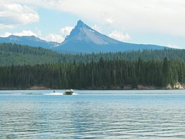
A boat tows a water skier on Lemolo Lake. Mount Thielsen is in the background.
|
|
| Location | Douglas County, Oregon |
| Coordinates | 43°18′47″N 122°11′05″W / 43.31297°N 122.1846°W |
| Type | reservoir |
Lemolo Lake is a beautiful lake and reservoir located in Douglas County, Oregon. It sits within the Umpqua National Forest, about 30 miles (48 km) north of Crater Lake National Park. The lake is part of the North Umpqua River system.
The name "Lemolo" comes from the Chinook Jargon language. It means "wild" or "untamed." The United States Forest Service manages the lake and its surrounding area.
Contents
History of Lemolo Lake
For many years before the 1880s, Native American groups were the main users of the land around Lemolo Lake. They lived and hunted in this area.
In the 1880s, white settlers began to arrive. They used the land mostly for grazing their sheep. In 1908, new rules were put in place to manage how much grazing could happen around Lemolo and Diamond Lakes.
Most of the land around Lemolo Lake stayed wild for a long time. Some changes did happen, though. A road was built in 1939, which later became Highway 138 in 1964. Telephone lines were also installed between 1909 and 1965.
Building the Dams
A big change came between 1952 and 1956 when two dams were built. These dams created the reservoir that we now call Lemolo Lake. They are called Lemolo #1 and Lemolo #2 Forebay.
- Lemolo #1 Dam was finished in 1955 and is 120 feet (37 meters) tall.
- Lemolo #2 Forebay Dam was built in 1956 and is 30 feet (9 meters) tall.
These dams are part of a larger project called the North Umpqua Hydroelectric Project. They work together to generate 65 megawatts of electricity. This project is owned and operated by a company called PacifiCorp.
Later, between 1963 and 1984, cabins and the only store were built at Lemolo Lake. There was also some timber harvesting and replanting in the area from the 1950s to the 1990s.
Location and Geography
Lemolo Lake is located high up in the mountains, about 4,075 feet (1,242 meters) above sea level. It's in the eastern part of the Umpqua National Forest.
The lake is like the top point of a triangle. The other two points are Diamond Lake to the south and Miller Lake to the southeast. Unlike Diamond Lake, Lemolo Lake is more remote. You can only reach it by special National Forest Development Roads.
From Lemolo Lake, you can enjoy amazing views of nearby mountains. These include Mount Bailey and Mount Thielsen, which are both south of the lake. You can also see Cinnamon Butte.
Recreation at Lemolo Lake
Lemolo Lake is a popular spot for outdoor fun all year round.
Summer Activities
During the summer, many people visit Lemolo Lake for camping and fishing. There are three campgrounds, areas for RVs, cabins, and a small hotel with four units.
Some of the most popular things to do in summer include:
- Fishing for trout
- Swimming in the lake
- Hiking on nearby trails
- Water skiing
You can use personal watercraft like jet skis on the lake. However, the marina at the lake does not rent out speed-boats or jet skis. So, if you want to water ski, you need to bring your own boat.
Water Safety and Health Notices
Sometimes during the summer, tiny living things called blue-green algae can grow in the lake. These algae can sometimes be harmful to your health.
It's important to know that these algae blooms don't happen every year. They also don't always appear at the same time. Before you visit, it's a good idea to check with the United States Forest Service (USFS) for any warnings about the water conditions.
In recent years, there have been successful efforts to reduce the algae growth in Lemolo Lake and nearby Diamond Lake. This has happened partly because invasive fish species, like the Tui chub, have been removed from the lakes. In 2009, the amount of algae in Lemolo Lake was much lower than in previous years.
Winter Activities
Unlike many other campsites in high places, the cabins and camping areas at Lemolo Lake stay open all year. This means you can enjoy many fun winter activities, such as:
- Winter camping
- Snow-shoeing
- Hiking in the snow
- Nordic skiing (cross-country skiing)
- Snowmobiling
 | Shirley Ann Jackson |
 | Garett Morgan |
 | J. Ernest Wilkins Jr. |
 | Elijah McCoy |


