
Crater Lake National Park facts for kids
Quick facts for kids Crater Lake National Park |
|
|---|---|
|
IUCN Category II (National Park)
|
|

Panoramic view of Crater Lake
|
|

Crater Lake National Park
Location in the United States
|
|
| Location | Klamath County, Oregon, United States |
| Nearest city | Klamath Falls |
| Area | 183,224 acres (741.48 km2) |
| Established | May 22, 1902 |
| Visitors | 756,344 (in 2016) |
| Governing body | National Park Service |
| Website | Crater Lake National Park |
Crater Lake National Park is a very special National Park located in southern Oregon. It was created in 1902, making it the fifth-oldest national park in the U.S.. It's also the only national park you'll find in Oregon! The park is famous for Crater Lake, which sits inside the huge bowl of an old, collapsed volcano called Mount Mazama. The park also includes the beautiful hills and forests around the lake.
Crater Lake is incredibly deep. At its deepest point, it's about 1,949 feet (594 meters) down! This makes it the deepest lake in the United States. It's also the second-deepest in North America and the ninth-deepest in the whole world. The lake's amazing depth comes from the way it was formed. About 7,700 years ago, Mount Mazama erupted with incredible force and then collapsed, creating a huge, deep bowl. The area also gets a lot of rain and snow, which helps keep the lake full.
What's really cool about Crater Lake is that no rivers or streams flow into or out of it. All the water in the lake comes from rain and snow. Water leaves the lake only by evaporating into the air or by slowly seeping into the ground. The water in Crater Lake is known for its stunning, bright blue color.
How Crater Lake Was Formed

The land in this part of Oregon is very active. Two huge pieces of the Earth's crust, called the Juan de Fuca Plate and the North American Plate, are slowly pushing against each other. When they meet, one plate slides under the other. This movement creates a lot of heat and pressure. Over millions of years, this process has built a long chain of volcanoes, known as the Cascade Range. The biggest volcanoes in this chain are called the High Cascades.
About 400,000 years ago, Mount Mazama began to grow, just like other volcanoes in the High Cascades. As this young, cone-shaped volcano got bigger, many smaller volcanoes and vents (places where lava comes out) formed nearby.
After a long quiet period, Mount Mazama became active again. Then, around 5700 BC, something amazing happened. Mount Mazama erupted with a tremendous explosion! After this huge eruption, the top of the mountain collapsed inward, forming a giant bowl. The mountain lost about 2,500 to 3,500 feet (760 to 1,070 meters) of its height. This giant bowl then filled with water over about 740 years, creating the beautiful, deep blue lake we now call Crater Lake.
The eruption that destroyed Mount Mazama was incredibly powerful. It spread volcanic ash over a huge area. Ash from this eruption has been found as far east as Yellowstone National Park, as far south as central Nevada, and as far north as southern British Columbia. This eruption produced more than 150 times more ash than the famous 1980 eruption of Mount St. Helens!
Amazing Animals
Many different animals call Crater Lake National Park home. You might spot a Canadian lynx or a bobcat silently moving through the trees. Look for beavers building dams, and tiny chipmunks and pikas scurrying around. Other animals include foxes, cougars, squirrels, porcupines, and black bears. You might also see coyotes, timber wolves, badgers, deer, elk, muskrats, and martens.
Many birds fly through the park too. Keep an eye out for American dippers, Peregrine falcons, ravens, Clark's nutcrackers, gray jays, and majestic bald eagles. You might even see tiny hummingbirds or a spotted owl. On the lake, Canada geese often float peacefully.
Fun Things to Do

Crater Lake National Park offers many exciting activities for visitors. There are lots of hiking trails to explore, and several campgrounds where you can stay overnight.
If you like fishing, you're in luck! You can fish in Crater Lake without needing a license, and there are no limits on how many fish you can catch or what size they are. The lake didn't originally have any fish. But starting in 1888, several types of fish were put into the lake. Now, Kokanee salmon and rainbow trout live and reproduce naturally here.
Swimming is allowed in the lake, which is a unique experience! You can also take boat tours that go around the lake and even stop at Wizard Island. Wizard Island is a small volcano cone that rises out of the lake. To get to the lake's edge, everyone uses the Cleetwood Trail. It's a steep walking path, as there are no roads for cars or trucks down to the water. All the boats on the lake had to be brought in by helicopter!
You can also enjoy amazing views from many spots along the caldera rim. The "Rim Drive" is a 33-mile (53 km) road that goes around the lake. It offers incredible views and climbs about 3,800 feet (1,160 meters) in elevation.
The highest point in Crater Lake National Park is Mount Scott. It stands at 8,929 feet (2,722 meters) tall. To reach the top, you'll need to take a fairly steep 2.5-mile (4 km) hike from the Rim Drive. On a clear day, you can see more than 100 miles (160 km) from the summit!
Images for kids
-
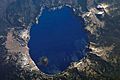
Satellite view of Crater Lake
-
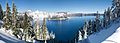
November panorama from Rim Village. During the winter, the road up to Rim Village is normally plowed but Rim Drive is closed.
-
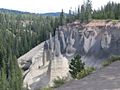
The Pinnacles
-
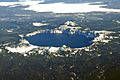
Aerial view of Crater Lake
-
View up to Watchman Trail and peak
-
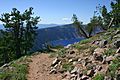
Garfield Peak trail, view east towards Crater Lake
.jpg)


.jpg)


See also
 In Spanish: Parque nacional del Lago del Cráter para niños
