
Wizard Island facts for kids
Quick facts for kids Wizard Island |
|
|---|---|
.jpg) |
|
| Highest point | |
| Elevation | 6,933 ft (2,113 m) |
| Prominence | 755 ft (230 m) (varies with water level) |
| Geography | |
| Location | Klamath County, Oregon, U.S. |
| Parent range | Cascades |
| Topo map | USGS Crater Lake West |
| Geology | |
| Mountain type | Cinder cone |
| Volcanic arc | Cascade Volcanic Arc |
| Last eruption | About 4600 BC |
| Climbing | |
| Easiest route | Trail with boat access |
Wizard Island is a special island found in Crater Lake in Crater Lake National Park, Oregon. It's actually a cinder cone, which is a type of small volcano. The island sits at the west end of the lake.
The highest point of Wizard Island is about 6,933 feet (2,113 meters) above sea level. This means it rises about 755 feet (230 meters) above the usual surface of Crater Lake.
At the very top of the island, there's a bowl-shaped opening called a volcanic crater. This crater is about 500 feet (150 meters) wide and 100 feet (30 meters) deep. In 1885, a person named William Gladstone Steel gave the crater the name "Witches Cauldron." He also named the island "Wizard Island" at the same time.
The island covers an area of about 315.85 acres.
How Wizard Island Was Formed
Wizard Island was made a very long time ago, about 7,700 years ago. This happened after a huge volcano called Mount Mazama erupted with great power. This massive eruption caused the top of Mount Mazama to collapse, creating a giant bowl-shaped hollow called a caldera. This caldera is now filled with water and is what we know as Crater Lake.
After the main eruption, the area where the mountain once stood was a deep hole, about 4,000 feet (1,200 meters) deep. Over the next few hundred years, smaller eruptions happened on the floor of this caldera. These eruptions built up several smaller volcanoes, known as cinder cones.
Wizard Island is the tallest of these cinder cones. It is the only one that rises above the water level of Crater Lake. It stands more than 2,700 feet (820 meters) above the deepest part of the lake floor.
There is another large cinder cone in the lake called Merriam Cone. It is in the northeast part of Crater Lake. Merriam Cone rises about 1,400 feet (430 meters) from the lake floor. However, its top is still about 505 feet (154 meters) below the average water level. Scientists believe Merriam Cone formed completely underwater because of how its surface looks and because it doesn't have a crater.
Visiting Wizard Island
You can visit Wizard Island only during the summer. This is when boat tours operate on Crater Lake. The boats leave from a place called Cleetwood Cove, which is at the north end of the lake.
The boat tours travel around the lake. They make a stop at a dock located in Governors Bay, on the south side of Wizard Island.
If you take an early boat trip, you might be able to get off and explore the island. However, you need to be ready to stay on the island for the whole day. This is because later boats might be too full to pick up extra passengers. People on boat trips in the late afternoon are not allowed to get off the boat at the island.
At the end of each day, a special boat comes to pick up anyone still on the island. Remember, you are not allowed to camp overnight on Wizard Island.
There are two hiking trails on Wizard Island. One trail goes up the side of the volcano and around the crater at the top. The other trail starts from the dock and leads towards the western part of the island.
-
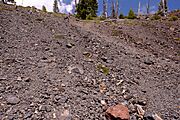
Looking up out of the crater of Wizard Island from the bottom.
-
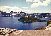
Crater Lake and Wizard Island in 1997.
-
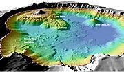
This map shows the depth of Crater Lake, including Wizard Island and Merriam Cone.
-
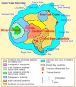
A map showing the different types of rocks and features on Wizard Island and the lake floor.


