
Mount Thielsen facts for kids
Quick facts for kids Mount Thielsen |
|
|---|---|

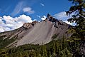
Mount Thielsen's eroded edifice from the Pacific Crest Trail
|
|
| Highest point | |
| Elevation | 9,184 ft (2,799 m) NAVD 88 |
| Prominence | 3,342 ft (1,019 m) |
| Listing | Oregon county high points |
| Geography | |

Mount Thielsen
Location in Oregon
|
|
| Location |
|
| Parent range | Cascades |
| Topo map | USGS Mount Thielsen |
| Geology | |
| Age of rock | About 290,000 years |
| Mountain type | Shield volcano |
| Volcanic arc | Cascade Volcanic Arc |
| Climbing | |
| First ascent | 1883 by E.E. Hayden |
| Easiest route | Scramble |
Mount Thielsen, also known as Big Cowhorn, is an old, inactive shield volcano in the Oregon Cascade Range. It's located near Mount Bailey. This mountain stopped erupting about 250,000 years ago. Over time, glaciers have worn down its shape. This erosion has made its sides very steep and given it a sharp, horn-like top.
Because of its pointy shape, Mount Thielsen often gets hit by lightning. These lightning strikes create a special, rare mineral called fulgurite. The mountain's unique horn shape makes it a central feature of the Mount Thielsen Wilderness. This area is a great place for outdoor activities like skiing and hiking. Thielsen is one of Oregon's "Matterhorns," a nickname for mountains with sharp, spire-like peaks.
Mount Thielsen formed because the Juan de Fuca Plate is slowly sliding under the North American Plate. This process has created volcanoes in the Cascades for millions of years. Thielsen is part of the High Cascades, a group of younger volcanoes in Oregon. It also belongs to a special group of inactive volcanoes known for their sharp, distinct peaks. The area around the volcano was first home to Klamath Native Americans. Later, explorers and settlers arrived.
Contents
How Mount Thielsen Got Its Name

Native American groups, like the Chinook and Klamath, lived in this area long ago. They had their own names for the mountain. The Klamath people called it "hisc'akwaleeas."
Later, an explorer named Jon Hurlburt renamed the volcano. He named it after Hans Thielsen, a railroad engineer. Hans Thielsen was important in building the California and Oregon Railroad.
In 1884, a team of scientists from the United States Geological Survey studied the Cascade Range. They climbed Mount Thielsen and collected samples of its unique rocks.
The Lightning Rod of the Cascades
Mount Thielsen's pointy top is hit by lightning very often. This happens so much that some rocks on the summit have melted! They turn into a rare material called lechatelierite, which is a type of fulgurite. Because of this, the mountain is sometimes called "the lightning rod of the Cascades."
In the 1800s, explorers also visited the area around Crater Lake, which is nearby. They were amazed by its deep blue water. Over time, more people came to see the lake. In 1902, President Theodore Roosevelt made Crater Lake and the surrounding area a national park.
Where Mount Thielsen Is Located
The Cascade Mountains

The Cascade Range was formed by two huge pieces of Earth's crust, called plates, crashing into each other. The Juan de Fuca Plate is slowly sliding under the North American Plate. This process has been creating volcanoes for about 36 million years.
The volcanoes in the Cascade Mountains are split into two main groups. These are the High Cascades and the Western Cascades. Mount Thielsen is part of the High Cascades, which are located to the east of the Western Cascades.
Nearby Landmarks

To the west of Mount Thielsen is Diamond Lake. This lake was actually formed by one of Thielsen's past eruptions. Beyond the lake is Mount Bailey, which is a younger volcano that hasn't been worn down as much.
Mount Thielsen's sharp peak is a famous sight from Crater Lake National Park. All three of these volcanoes are part of the Oregon High Cascades. This range includes other famous volcanoes like Mount Jefferson and the Three Sisters.
Mount Thielsen is one of several inactive volcanoes in Oregon known as "the Matterhorns." These mountains have steep, spire-like tops. Thielsen is the tallest of them, standing at about 9,182 feet (2,799 meters). Other "Matterhorns" include Mount Washington and Diamond Peak. Unlike other mountains in the High Cascades, these volcanoes stopped erupting a long time ago. Their unique shapes were carved by ice age glaciers.
What Mount Thielsen Is Made Of

Mount Thielsen has been so deeply worn away by glaciers that it no longer has a crater at its top. The upper part of the mountain looks like a sharp horn. Thielsen is an older volcano in the Cascade Volcanic Arc. It stopped erupting relatively early in its history. The marks left by erosion from the last few ice ages can still be seen.
The volcano's cone sits on top of older shield volcanoes. It is made of basaltic andesite, which is a common rock in Oregon's Cascade volcanoes. It also contains breccia and tuff. The cone formed from pyroclastics (bits of rock and ash) and lava that spewed out like fountains. Glaciers later carved and changed the cone's shape, wearing away its top. This erosion lets us see inside the volcano's structure.
Scientists have studied the rocks from Mount Thielsen. They found that the volcano is at least 290,000 years old. It erupted for a short period, stopping about 100,000 to 250,000 years ago.
Glaciers on Thielsen
Glaciers covered Mount Thielsen until the early 1900s. Large glaciers from the Pleistocene ice age carved out much of Thielsen's shape. Today, only a small glacier called the Lathrop Glacier remains on the northern side of the volcano.
Special Rocks: Fulgurites
Fulgurites are special rocks that form when lightning melts other rocks. On Mount Thielsen, fulgurites are found only at the very top of the mountain. They are usually found within 5 to 10 feet (1.5 to 3 meters) of the summit.
Lightning strikes the summit regularly, creating patches of dark, glassy rock. These patches can be small, just a few centimeters across, or long and narrow, up to 12 inches (30 cm) long. Some look rough and spongy, while others are flat. When scientists look closely at fulgurite, they see a smooth glass layer over a layer of basalt. In between, there's a layer made of minerals like feldspar and pyroxene.
Animals and Plants Around Thielsen

The area around Mount Thielsen is home to many plants and animals. Near Diamond Lake, you can find huge incense cedar trees. There's also a forest of ponderosa pine trees on a nearby trail.
The Umpqua National Forest has swordferns and Douglas fir trees. In the Fremont–Winema National Forest, you might see Rocky Mountain elks, pronghorns, and mule deer. Other animals living here include bobcats, black bears, and mountain lions. The rivers in the forest have trout, and the lakes have fish like largemouth bass.
Many birds also live in the forest. You can find mallards, American bald eagles, Canada geese, and whistling swans. Sometimes, Peregrine falcons are also seen here.
The lower parts of Mount Thielsen are covered in thick forests. These forests don't have a huge variety of plant species. You'll mostly see mountain hemlock and fir trees growing up to the tree line, which is around 7,200 feet (2,195 meters) high. Near the very top of the volcano, whitebark pine trees are common.
Fun Things to Do at Mount Thielsen
Mount Thielsen is located in the southern part of the Mount Thielsen Wilderness. This wilderness area is part of the Deschutes, Umpqua, and Fremont–Winema national forests.
The wilderness and forests offer many activities related to the mountain. You can go hiking and skiing there. The wilderness covers about 55,100 acres (223 square kilometers) around the volcano. It has beautiful lakes and alpine parks.
The famous Pacific Crest National Scenic Trail also runs through this area for about 26 miles (42 kilometers). You can get to this trail from a starting point along Oregon Highway 138. In 2009, this trail was even chosen as Oregon's best hike! For those who like skiing, there are three challenging black diamond ski trails on the mountain.
Images for kids
-
Mount Thielsen's eroded edifice from the Pacific Crest Trail
-
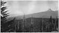
Mount Thielsen seen from the south in the 1930s
-
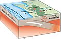
The Juan de Fuca Plate is sliding under the North American Plate, creating volcanoes.
-
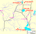
This map shows major volcanoes near Thielsen in the Southern Oregon Cascade Range.
-
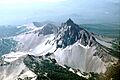
An aerial view of Mount Thielsen.
-
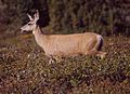
Mule deer live in the forests around Mount Thielsen.
See also
 In Spanish: Monte Thielsen para niños
