Mount Washington (Oregon) facts for kids
Quick facts for kids Mount Washington |
|
|---|---|

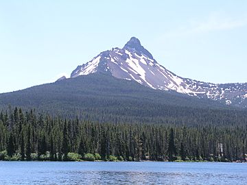
Mount Washington as seen from Big Lake on the northwest
|
|
| Highest point | |
| Elevation | 7,795 ft (2,376 m) |
| Geography | |
| Parent range | Cascade Range |
| Topo map | USGS Mount Washington |
| Geology | |
| Formed by | Subduction zone volcanism |
| Age of rock | Pleistocene |
| Mountain type | Shield volcano, stratovolcano, volcanic plug |
| Volcanic arc | Cascade Volcanic Arc |
| Last eruption | >250,000 years ago (estimated) |
| Climbing | |
| First ascent | 1923 by E. McNeal and party |
Mount Washington is an old volcano in the Cascade Range of Oregon. It sits between Deschutes and Linn counties. A special protected area called the Mount Washington Wilderness surrounds it.
Like other mountains in the Oregon Cascades, Mount Washington was formed by huge tectonic plates crashing together. This happened during the late Pleistocene era, which was a long time ago! The volcano is mostly made of dark volcanic rock called basalt. It has a volcanic plug at its top, which is like a stopper in the volcano's vent. You can also find smaller cinder cones and spatter cones nearby. The last time this area had eruptions was about 1,350 years ago from these spatter cones.
Mount Washington's surroundings are quite rugged and haven't been used much for fun activities in the past. A road was built at McKenzie Pass in 1872 and later paved in the 1930s. The first time people climbed to the top of Mount Washington was on August 26, 1923. Six boys from the city of Bend made this exciting climb! In 1964, the government made the area around the mountain a wilderness. This means it's protected and kept wild. Even though it's a wilderness, it has some hiking trails. You won't see a lot of animals, but there are deer, American black bears, and cougars. The plants are mostly pines and shrubs.
Contents
Exploring Mount Washington
Mount Washington stands tall at about 7,795 feet (2,376 meters) above sea level. It's located in Deschutes and Linn counties in Oregon. The mountain is north of McKenzie Pass and about 12 miles (19 km) west of the city of Sisters. You can only reach it by hiking trails. Parts of the famous Pacific Crest Trail also cross the western and southwestern sides of the mountain.
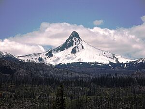
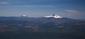
Even though it's not the biggest volcano in the Oregon Cascades, Mount Washington is a very noticeable landmark. It stands out between North Sister and Three Fingered Jack. The mountain has a unique, pointy shape, almost like a spire. Some people say it looks like Cleopatra's Needle or even Sugarloaf Mountain in Brazil from different angles!
Weather and Landscape
The land around Mount Washington ranges from about 3,200 feet (975 meters) to over 7,700 feet (2,347 meters) high. Most of the rain and snow falls during the winter. Summers are usually warm and dry. In winter, the Cascade Mountains get a lot of snow. One road, Oregon Route 242 over McKenzie Pass, closes from fall until late spring because of the snow. However, other main roads like Santiam Highway stay open all year.
The Mount Washington Wilderness has cool features left behind by glaciers. These include flat areas called outwash plains and piles of rock and dirt called moraines. These were formed during the last big ice age, when a huge ice sheet covered the area. The McKenzie River starts from Clear Lake and flows near Mount Washington.
Mount Washington Wilderness
The Mount Washington Wilderness is a large protected area, covering about 54,278 acres (219.65 km2). It was first recognized as a "wild area" in 1975 and became an official wilderness area in 1964. This wilderness is about 32 miles (51 km) west of Bend. It's one of three wilderness areas in the central part of Oregon's High Cascades. The other two are the Three Sisters Wilderness and Mount Jefferson Wilderness.
People mostly visit this area for hunting, hiking, and climbing. You can find the Dee Wright Observatory here, along with smaller volcanoes. The Pacific Crest Trail runs through the wilderness for about 16.6 miles (26.7 km). Other important spots include Belknap Crater and 28 beautiful lakes. The Willamette National Forest and Deschutes National Forest work together to manage this wilderness.
Plants and Animals
Much of the Mount Washington Wilderness is made up of old lava flows and rocky areas. But it also has forests and 28 lakes, especially in the northern and southwestern parts.
Plants of the Wilderness
You can find several types of trees here, like mountain hemlock, lodgepole pine, ponderosa pine, and whitebark pine. Ponderosa pines grow at the eastern base of the volcano, while Douglas firs are on the western side. Not many plants grow directly on the old lava flows. However, mountain hemlock can grow on lava, and you'll see smaller plants like beargrass, huckleberry, and rhododendron underneath the trees.
Animals of the Wilderness
The wilderness is home to large animals such as deer and elk. You might also spot a rare American black bear or cougar. Smaller animals like pikas, marmots, martens, snowshoe hares, and ground squirrels live here too. The lakes in the wilderness are full of fish like brook trout, cutthroat trout, and rainbow trout. You can also see frogs around some of the lakes.
History of the Area
Because Mount Washington's surroundings are so rugged, people didn't use them much for fun activities in the past. A wagon road was built at McKenzie Pass in 1872. This road was paved in the 1930s and became Oregon Route 242. The road got its name from the nearby McKenzie River, which was named after Donald McKenzie. He was a fur trader who explored the area way back in 1812.
As mentioned before, the first time people climbed Mount Washington was on August 26, 1923. Six boys from Bend were the first to reach the top: Ervin McNeal, Phil Philbrook, Armin Furrer, Wilbur Watkins, Leo Harryman, and Ronald Sellars.
Before the area became a wilderness in 1964, there were plans to use the land for cutting down trees. But people argued that protecting the area would make it better for "wilderness" and nature. So, it became a protected wilderness area.
How Mount Washington Formed
Volcanoes in Oregon's Cascade Range, like Mount Washington, are formed when the Juan de Fuca tectonic plate slides under the North American tectonic plate. This process is called subduction. Mount Washington is part of a chain of volcanoes in central Oregon that formed from lava flows and cinder cones.
Mount Washington is one of Oregon's "Matterhorns." This group of volcanoes also includes Mount Thielsen, Three Fingered Jack, Mount Bailey, and Diamond Peak. They are called Matterhorns because their pointy tops look a bit like the famous Matterhorn mountain in Switzerland. These volcanoes stopped erupting a very long time ago, at least 100,000 to 250,000 years ago. Because they are so old, glaciers have carved and shaped them a lot over time.
Scientists debate whether Mount Washington is a stratovolcano (a cone-shaped volcano with steep sides) or a shield volcano (a wider, flatter volcano). Some call it a "mafic shield volcano," while others describe it as a "glacially-gutted Pleistocene stratovolcano." It's made of different materials and has steep slopes.
Mount Washington is about 3 miles (5 km) wide. It has a summit cone at its top and a volcanic plug made of rock that fills its central vent. This plug is about 0.25 miles (0.4 km) wide. You can also see dikes, which are sheets of rock that formed when magma squeezed into cracks.
The volcano is made of a type of rock called basalt and basaltic andesite. These rocks are rich in magnesium and iron. Some rocks on the mountain's northeastern slope suggest that there might have been an eruption under a glacier a long time ago.
Over many years, Mount Washington has been worn down by weather and glaciers. It now has U-shaped valleys and bowl-shaped hollows called cirques. Scientists think Mount Washington used to be even taller, perhaps reaching about 8,530 feet (2,600 meters) high.
Smaller Volcanoes Nearby
The area around Mount Washington has several smaller volcanoes. These include Cache Mountain, Little Cache Mountain, Hayrick Butte, and Hoodoo Butte. The Mount Washington Wilderness also has many cinder cones, which are usually between 150 and 300 feet (46 and 91 meters) tall. These cones are made of gray to red cinder and other volcanic rocks. Some of the main cinder cones in the wilderness are Belknap Crater, Twin Craters, Scott Mountain, and the Sand Mountain craters.
The most recent volcanic activity at Mount Washington came from a line of spatter cones. These cones are about a mile long and point northeast. They erupted basaltic andesite lava. Scientists believe these spatter cones and activity from nearby Blue Lake Crater were the most recent eruptions in this region.
It's possible that new small volcanic cones could form at the base of Mount Washington in the future. However, scientists believe the main volcano itself is probably not active anymore.
Fun Activities
Even though this wilderness area isn't as busy as some others in Oregon, it offers beautiful lakes and trails. The Pacific Crest Trail goes along the western side of Mount Washington. Other trails include a loop around the Patjens Lakes, the Hand Lake trail, and the Benson Lake route.
Climbing Mount Washington itself is known to be very difficult and dangerous. It's not recommended for people who don't have a lot of climbing experience or the right gear.
 | Jackie Robinson |
 | Jack Johnson |
 | Althea Gibson |
 | Arthur Ashe |
 | Muhammad Ali |


