McKenzie River (Oregon) facts for kids
Quick facts for kids McKenzie River |
|
|---|---|
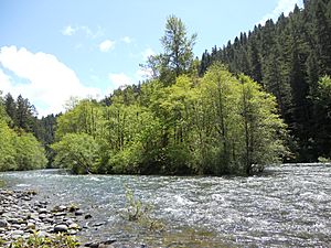
An island in the upper McKenzie
|
|
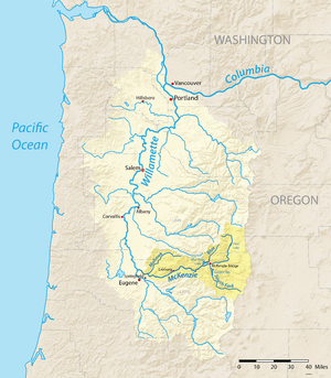
Map of the Willamette River basin with the McKenzie River highlighted
|
|
|
Location of the mouth of the McKenzie River in Oregon
|
|
| Country | United States |
| State | Oregon |
| Counties | Lane, Linn |
| Physical characteristics | |
| Main source | Clear Lake Cascade Range, Linn County 3,570 ft (1,090 m) 44°21′37″N 121°59′39″W / 44.36028°N 121.99417°W |
| River mouth | Willamette River Lane County 371 ft (113 m) 44°7′32″N 123°6′20″W / 44.12556°N 123.10556°W |
| Length | 90 mi (140 km) |
| Basin features | |
| Basin size | 1,300 sq mi (3,400 km2) |
| Type: | Recreational |
| Designated: | October 28, 1988 |
The McKenzie River is a 90-mile (145 km) long river in western Oregon, United States. It's a major branch of the Willamette River. The McKenzie River flows from the Cascade Range east of Eugene and empties into the southern Willamette Valley. The river is named after Donald McKenzie. He was a fur trader from Scotland and Canada. He explored parts of the Pacific Northwest in the early 1800s. Today, six large dams are built on the McKenzie River and its smaller streams.
Contents
River's Journey
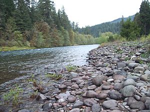
The McKenzie River starts at Clear Lake. This lake is high up in the Cascades in eastern Linn County. The river flows south from Clear Lake. It passes over the beautiful Sahalie and Koosah waterfalls. Then it reaches Carmen Reservoir, which is a lake made by people.
From Carmen Reservoir, some river water goes into a 2-mile (3.2 km) tunnel. This tunnel leads to Smith Reservoir. For about 3 miles (4.8 km) between Carmen Reservoir and Tamolitch Falls, the riverbed is dry. This happened because lava from Belknap Crater covered this part of the river about 1,600 years ago. The river flows under the lava in this section. It then comes back to the surface at Tamolitch Pool, at the bottom of Tamolitch Falls.
The river then flows south into Trail Bridge Reservoir. Here, the Smith River joins it from the right side. After passing through Trail Bridge Dam, the McKenzie River enters Lane County. It continues south to Belknap Springs. There, it turns west and flows past the town of McKenzie Bridge.
The South Fork McKenzie River joins the main river about three miles east of Blue River. The South Fork starts near the Pacific Crest Trail. It flows for about 30 miles (48 km) through Cougar Reservoir and Cougar Dam. After the South Fork joins, the McKenzie River flows west through a narrow valley. The Blue River joins it from the north at the town of Blue River.
The McKenzie then passes Vida, Leaburg, and Walterville. The valley gets wider as the river flows west. The Mohawk River joins it from the northeast, just north of Springfield. Finally, the McKenzie River leaves the mountains and enters a wide, flat area. It joins the Willamette River from the east, about 5 miles (8 km) north of Eugene.
River's Land Area
The McKenzie River drains an area of about 1,300 square miles (3,400 km2). It is one of the main branches of the Willamette River. The land in this area ranges from 10,358 feet (3,157 m) high at the top of the South Sister mountain. It goes down to 375 feet (114 m) at the McKenzie's mouth on the Willamette River.
Most of the land around the river is not heavily populated. About 70 percent of it is public land. The U.S. Government manages this land. About 39 percent of it is the Three Sisters Wilderness. Over 96 percent of the area is covered by forests. Less than 4 percent is used for farming, mostly farms and fruit orchards. The rest is for homes or businesses.
The Willamette National Forest covers most of the public land. This area is important for logging and outdoor fun. The McKenzie River is the only source of drinking water for Eugene and Springfield. It provides water for about 200,000 people. The Eugene Water & Electric Board (EWEB) takes water from the river at river mile 11 (or river kilometer 18) in Springfield.
The water quality in the McKenzie River is very good. It's even better upstream than downstream. The main things that can make the water less clean are farming and homes. This includes septic systems. Small amounts of weed killers have been found in the river. These might come from planes spraying forests.
The region has a mild climate. Winters are wet, and summers are dry. About 90 percent of the rain and snow falls between October and May. The amount of rain and snow changes a lot with how high up the land is. About 40 inches (1,000 mm) fall each year in the Willamette Valley. But the Three Sisters mountains can get 125 inches (3,200 mm) in a year.
Above 4,000 feet (1,200 m), about 35 percent of the water comes from snow. At 7,000 feet (2,100 m) and higher, over 75 percent is snowfall. When this snow melts in spring, it brings cold water from springs. This keeps the McKenzie River and its smaller streams cold. In the lower McKenzie, winter rain runs off the ground easily. This can cause dirt to wash into the river.
River Engineering and Dams
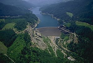
There are six main dams in the McKenzie River area. Three are on the McKenzie River itself. The other three are on different streams that flow into the McKenzie. The dams on the McKenzie River create Carmen Reservoir, Trail Bridge Reservoir, and Leaburg Reservoir. The other dams are Smith River dam, Cougar Dam on the South Fork McKenzie River, and Blue River Dam on the Blue River.
The Carmen Diversion Dam is the highest dam on the McKenzie. It's less than 2 miles (3.2 km) south of Clear Lake, where the river begins. Water from Carmen Reservoir is sent through a tunnel to Smith Reservoir. From Smith Reservoir, water goes through another tunnel to the Carmen Power Plant. Then it flows into Trail Bridge Reservoir. This water then goes through the power-producing Trail Bridge Dam.
This system is called the Carmen–Smith Hydroelectric Project. The Eugene Water & Electric Board has used it since 1963. It makes electricity for EWEB customers. The system can produce 114 megawatts of power. EWEB also manages two power-producing canals further down the McKenzie River. The Walterville Canal was finished in 1910. The Leaburg Canal was finished in 1930. Both canals take water from the McKenzie to make electricity. Most of the water goes back into the river after making power.
Towns and Communities
The eastern part of Oregon Route 126 follows the McKenzie River valley. It stays close to the river for most of its path. The 60-mile (97 km) stretch of the river from Springfield to the Cascades is called the McKenzie Valley. Here are some towns in the valley, from west to east:
- Cedar Flat
- Walterville
- Deerhorn
- Leaburg
- Vida
- Nimrod
- Finn Rock
- Blue River
- Rainbow
- McKenzie Bridge
- Belknap Springs
River History
Native American tribes have lived along the McKenzie River for about 8,000 years. More recently, the Kalapuya and Molala tribes lived here. They moved around in the summer and spent winters in the lower valley. This way of life continued until the mid-1800s. At that time, many native people died from diseases. Others were moved to special reservations.
The first time white explorers recorded visiting the river was in the spring of 1812. The Pacific Fur Company reached the McKenzie River by way of the Willamette River. This was part of a bigger exploration led by Donald McKenzie. His company had set up a trading post in 1811 at Fort Astoria. McKenzie and his group explored the Willamette River. They found a large river flowing into the Willamette and named it after McKenzie.
However, most of the McKenzie River was not visited by white settlers until October 1853. A group of Oregon Trail settlers got lost. They were trying to cross the Cascades into the Willamette Valley. They used a path called the Elliott Cutoff.
In 1910, people made the first car trip over McKenzie Pass. But crossing the pass was only possible in summer. Winter weather closed the pass. People could not travel year-round until 1960. That's when a road over Santiam Pass was finished.
Plants and Animals
Many types of fish live in the McKenzie River and its smaller streams. These include:
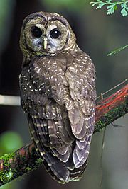
Birds like dippers, mergansers, bald eagles, ospreys, and different kinds of ducks eat these fish. The threatened northern spotted owl lives in the thick forests. You can find them on the west side of the upper McKenzie area in Linn County.
Most of the land around the river is covered by forests. These forests have many Douglas fir trees. They also have western hemlock and western red cedar trees.
Fun Activities
The McKenzie River is a popular place for boating. People especially enjoy fishing, kayaking, and whitewater rafting. The McKenzie River dory is a special type of boat. It was designed for whitewater and first used on the McKenzie in the 1940s. This boat design became popular on other rivers like the Rogue and the Colorado. Boating is also common on Blue River Reservoir and Cougar Reservoir.
Hiking and mountain biking are popular activities on trails in the McKenzie area. One famous trail is the 26.5-mile (42.6 km) McKenzie River National Recreation Trail. It follows a large part of the upper McKenzie River.
 | Delilah Pierce |
 | Gordon Parks |
 | Augusta Savage |
 | Charles Ethan Porter |


