
South Fork McKenzie River facts for kids
Quick facts for kids South Fork McKenzie River |
|
|---|---|

South Fork McKenzie River
|
|

Location of the mouth of the South Fork McKenzie River in Oregon
|
|
| Country | United States |
| State | Oregon |
| County | Lane |
| Physical characteristics | |
| Main source | near Mink Lake Three Sisters Wilderness, Cascade Range 4,559 ft (1,390 m) 43°56′36″N 121°55′32″W / 43.94333°N 121.92556°W |
| River mouth | McKenzie River near Blue River 1,093 ft (333 m) 44°09′32″N 122°17′44″W / 44.15889°N 122.29556°W |
| Length | 31 mi (50 km) |
| Basin features | |
| Basin size | 213 sq mi (550 km2) |
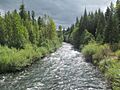
The South Fork McKenzie River is a river in Oregon, United States. It is about 31 miles (50 km) long. This river is a tributary, which means it flows into a larger river. The South Fork McKenzie River joins the McKenzie River.
The river starts high up in the Cascade Range mountains. It begins near Mink Lake in the Three Sisters Wilderness. The river flows through Lane County and eventually meets the McKenzie River.
A big structure called Cougar Dam is built on the South Fork McKenzie River. This dam creates Cougar Reservoir. It was built in 1963 by the United States Army Corps of Engineers. The dam helps to make hydroelectricity (power from water) and stops floods.
The area around the river is a great place for fun activities. You can go fishing, swimming, hiking, and camping. On Cougar Reservoir, people enjoy waterskiing and boating. There is also a popular hot springs nearby. Some people who like Whitewater sports enjoy the challenging parts of the upper river.
Contents
Journey of the South Fork McKenzie River
The South Fork McKenzie River begins its journey in the Cascade Range mountains. It starts at a high elevation of about 4,600 feet (1,400 meters) above sea level. Many small lakes are found near where the river starts, including Mink Lake, Porky Lake, and Mud Lake.
As the river flows, it passes through the Three Sisters Wilderness. This area is part of the Willamette National Forest. The river then leaves the wilderness area.
Further downstream, the river flows past Frissel Crossing Campground. It also goes under Forest Road 19, which then runs next to the river. Several smaller streams join the South Fork McKenzie River along its path. These include Roaring River, Fir Creek, and Cascade Creek.
The river continues to flow, passing Homestead Campground. It then turns and flows towards the northwest and then north. More creeks, like Augusta Creek, Starr Creek, and Blue Creek, add their water to the river.
As the river gets closer to its end, it flows into Cougar Reservoir. This is a large lake created by the Cougar Dam. Inside the reservoir, more creeks join the river, such as Ridge Creek and Smith Creek. The river also passes Cougar Crossing Campground and Slide Creek Campground.
After leaving Cougar Reservoir, the river flows past Cougar Dam and its power plant. Finally, the South Fork McKenzie River joins the main McKenzie River. This meeting point is near the town of Blue River.
Fun Activities on the South Fork McKenzie River

The South Fork McKenzie River area is perfect for outdoor adventures. Many people visit to go fishing, camping, hiking, swimming, and boating.
Boating and Camping at Cougar Reservoir
Cougar Reservoir is a popular spot for water activities. You can enjoy motorized boating, fishing, swimming, and waterskiing here. The United States Forest Service manages several campgrounds around the reservoir. These include Cougar Crossing, Slide Creek, and Sunnyside campgrounds. They offer places for camping, hiking, and picnicking. Other campgrounds nearby are French Pete and Delta.
Fishing in the River and Reservoir
Cougar Reservoir is home to different types of fish. You can find stocked rainbow trout and Chinook salmon there. The lake also has naturally living cutthroat trout. Another fish, the bull trout, lives in the lake, but it is against the rules to catch and keep them.
Fishing for cutthroat and bull trout is popular in the upper parts of the river. People often practice catch-and-release fishing here. This means they catch the fish and then let them go back into the water. The fish in the upper river are usually smaller, about 8 to 11 inches (20 to 28 cm) long.
Relaxing at Terwilliger Hot Springs
Near where Rider Creek meets the South Fork, you can find Terwilliger Hot Springs. This special place has six warm pools where you can relax. The pools are next to a waterfall and a cool rock formation. It's a popular spot, and you can pay a small fee to visit for the day.
Whitewater Rafting Adventures
For those who love excitement, there's a challenging part of the river for Whitewater sports. This section is about 8.5 miles (13.7 km) long. The rapids here can be quite difficult, ranging from class 3 to class 5 on the International Scale of River Difficulty. This means they are suitable for experienced paddlers.
Images for kids
-
South Fork McKenzie River
-
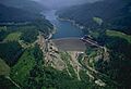
Cougar Dam on the South Fork
