
Matterhorn facts for kids
Quick facts for kids Cervino - Matterhorn |
|
|---|---|

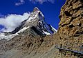
The Matterhorn, seen from Zermatt
|
|
| Highest point | |
| Elevation | 4,478 metres (14,693 feet) |
| Prominence | 1,029 m |
| Geography | |
| Location | |
| Parent range | Pennine Alps |
| Climbing | |
| First ascent | 14 July 1865 by Edward Whymper and party |
| Easiest route | Hörnli ridge (AD, rock/mixed climb) |
The Matterhorn is a very famous mountain in the European Alps. It stands tall at 4,478 metres (about 14,693 feet).
This amazing mountain sits right on the border between Switzerland and Italy. It looks down over the Swiss village of Zermatt and the Italian village of Breuil-Cervinia. The name "Matterhorn" comes from German words. Matte means valley or meadow, and Horn means peak.
Contents
How Tall is the Matterhorn?

The Matterhorn has two main tops, called summits. These are about 100 meters apart and form the border between Italy and Switzerland. People have been trying to measure the Matterhorn's height for a long time!
In 1792, a scientist named Horace Bénédict de Saussure used a special tool and a long chain to measure it. He figured it was about 4,501.7 meters tall. Later, in 1868, an Italian engineer named Felice Giordano used a mercury barometer to measure it as 4,505 meters.
In 1999, scientists used Global Positioning System (GPS) technology to get a super accurate measurement. They found the Matterhorn's summit is exactly 4,477.54 meters (about 14,690 feet) above sea level. This measurement was so precise, it was accurate to less than one centimeter! This helps them track any tiny changes in its height over time.
The Matterhorn is one of the highest mountains in the Alps. It's the sixth-highest peak in the Alps and Europe (not counting the Caucasus Mountains). It's also the fifth-highest in Switzerland and the third-highest in Italy's Valle d'Aosta.
Geography of the Matterhorn

The Matterhorn has a special pyramid shape with four sides, called faces. These faces point almost exactly towards the four main directions: north, east, south, and west. Three of these faces (north, east, and west) are on the Swiss side, and one (south) is on the Italian side.
The north face looks over the Zmutt Glacier and the valley above Zermatt. The east face looks towards the Gorner Glacier system. The west face looks over another part of the Zmutt Glacier. The south face faces the Italian town of Breuil-Cervinia. The Matterhorn isn't a perfect pyramid. Its north and south faces are wider than its west and east faces. Also, the top isn't a sharp point; it has a 100-meter-long flat ridge connecting the north and south faces.
The Matterhorn's faces are very steep. Only small patches of snow and ice can stick to them. Avalanches often send snow down to the glaciers at the bottom of each face. The biggest glaciers are the Tiefmattengletscher to the west and the Matterhorn Glacier to the north.
The border between Switzerland and Italy here is also the main watershed of the Alps. This means that water flowing down the north side of the mountain ends up in the Rhône River and eventually the Mediterranean Sea. Water flowing down the south side goes into the Po River and then the Adriatic Sea.
The Theodul Pass, a mountain pass at 3,295 meters, is the easiest way to cross between the two valleys and countries. Romans and other ancient people used this pass for trade long ago.
The four main ridges that separate the faces are popular climbing routes. The easiest and most common climbing path is the Hörnli ridge. The Lion ridge is the usual Italian route and is known for its great rock climbing.
The Matterhorn is surrounded by many other tall mountains in the Pennine Alps. This area, including the Matterhorn, the Weisshorn, the Dom, and Monte Rosa, has many of Western Europe's highest peaks.


Matterhorn Weather
The Matterhorn is a mountain that stands alone. Because it's so high and sits on the main Alpine watershed, the weather around it can change very quickly.
Its steep sides and isolated spot also make it likely to form special clouds called banner clouds. These clouds appear when air flows around the mountain, causing moisture in the air to condense on the side away from the wind.
Geology of the Matterhorn
The Matterhorn is mostly made of a type of rock called gneiss. This rock is part of something called the Dent Blanche klippe, which is a piece of the Apulian plate. This plate was once a small continent that broke away from Africa a long, long time ago, before the Alpine orogeny (the mountain-building process that created the Alps). Because of this, some people jokingly say the Matterhorn is an "African mountain"!
A famous Swiss explorer and geologist, Horace Bénédict de Saussure, was inspired by the Matterhorn. He thought about how such a huge mountain could have been formed and how its missing parts might have become the pebbles and sand we see in valleys today. He was thinking about how mountains are shaped by powerful natural forces.
How the Matterhorn Formed

The story of the Matterhorn's formation (and the whole Alps) began about 200 million years ago. Back then, there was a giant continent called Pangaea. It started to break apart into two big pieces: Laurasia (which included Europe) and Gondwana (which included Africa).
The rocks that make up the Matterhorn were originally part of Gondwana. A new ocean, the Tethys Ocean, formed between these continents. About 100 million years ago, the Apulian plate (a piece of Gondwana) started moving towards Europe. This caused the Tethys Ocean to close as its floor was pushed down under the Apulian plate.
The actual mountain-building began when the European continent crashed into the Apulian continent. This huge collision pushed and folded the Earth's crust, creating the massive rock layers and nappes that form the Alps.
The Matterhorn got its unique pyramid shape much more recently, over the last million years. At first, it was just a rounded hill. But because it's so high, its sides are covered in ice and snow. In warmer times, the ice melts and seeps into cracks in the rock. When it freezes again, it expands and breaks off pieces of rock. This process, called freeze-thaw, along with glaciers, carved out four bowl-shaped hollows (called cirques) around the mountain, giving it its famous shape.
Because of its instantly recognizable shape, many other mountains around the world are nicknamed the "Matterhorn" of their region!
Matterhorn Rocks
Most of the lower part of the Matterhorn is made of rocks from the ancient Piedmont-Liguria ocean floor, including ophiolites and sedimentary rocks. Up to about 3,400 meters, you can see layers of these rocks.
From 3,400 meters to the very top, the mountain is made of gneiss rock from the Dent Blanche nappe. This part is divided into two sections: the Arolla series and the Valpelline zone (which is the very summit). Other mountains nearby, like the Weisshorn and Dent Blanche, are also made of rocks from the Dent Blanche nappe.
Tourism and Trekking
For hundreds of years, the Alps have drawn explorers and climbers. The Matterhorn wasn't very well known until 1865. But after the first successful climb, which sadly ended in a tragic accident, many people became interested in the mountains around Zermatt.
To make it easier for people to visit, a railway was built in 1888, connecting Zermatt to the town of Visp. The first train arrived in Zermatt in 1891. Today, Zermatt is connected to St. Moritz by the famous Glacier Express train. However, there's no direct train to Breuil-Cervinia on the Italian side. Travelers who want to cross between the two villages often hire mountain guides to go over the 3,300-meter-high Theodul Pass. Zermatt is special because it's almost completely free of cars that use fuel; most vehicles there are electric.

More railways and cable cars have been built to help people reach higher parts of the area. The Gornergrat railway, opened in 1898, reaches an amazing height of 3,100 meters. Cable cars also go to the Unterrothorn and the Klein Matterhorn (Little Matterhorn), which at 3,883 meters, has the highest transportation system in Europe!
The Hörnli Hut (3,260 m) is a mountain hut that serves as the starting point for the most common climbing route up the Matterhorn. Hikers can easily reach it from Schwarzsee. The ski resorts of Zermatt and Breuil-Cervinia are connected by ski lifts over the Theodul Pass, allowing people to ski between Switzerland and Italy all year round.
The Matterhorn Museum in Zermatt tells the story of the region, from early climbing to modern tourism. Inside, you can see how a mountain village used to look and learn about the first, tragic climb of the Matterhorn. You can even see items that belonged to the climbers.
For adventurous trekkers, there's a special journey called the Tour of the Matterhorn. It takes about 10 days to complete. Many people consider it one of the most beautiful treks in the Alps. It follows old paths that have connected Swiss and Italian valleys for centuries. The route takes you through alpine meadows, forests, and across glaciers. It connects six valleys and three different cultures: German-speaking, French-speaking, and a mix of French and Italian. You need good weather and conditions to complete this challenging trek.
About two million visitors come to Zermatt every year. Sadly, climbing the Matterhorn can be dangerous. On average, about twelve people have died on the Matterhorn each year between 2005 and 2015.
Images for kids
-
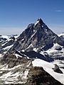
View on the south and east faces and the area of the Theodul Pass between Italy (left) and Switzerland (right)
-
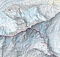
The Matterhorn on the National Map of Switzerland
-
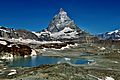
View on the east face with alpine lake
-
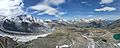
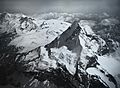
Aerial panorama of the Matterhorn from the Gornergrat 170622
-
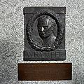
Plaque on the front wall of the Monte Rosa Hotel, commemorating the first ascent by Edward Whymper
-
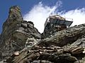
The Carrel Hut (3,830 m) on the Lion ridge
-
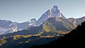
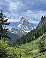
The Matterhorn seen from the Valtournenche Valley
-
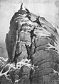
The first ascent of the Matterhorn, by Gustave Doré
-
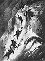
The first descent of the Matterhorn, by Gustave Doré
-
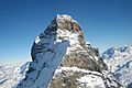
South-west side of the Matterhorn (Tyndall shoulder on the foreground)
-
The north and east faces of the Matterhorn.
-
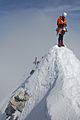
A climber standing on the summit.
-
Trail to the Hörnli Hut
-
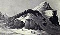
Theodulpass, c. 1800
-
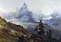
The Matterhorn by Edward Theodore Compton, 1879
-
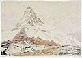
The Matterhorn by John Ruskin, 1849
-
Aerial photography by Eduard Spelterini in 1910


See also
 In Spanish: Cervino para niños
