
Pennine Alps facts for kids
Quick facts for kids Pennine Alps |
|
|---|---|
| French: Alpes Pennines, Alpes valaisannes, German: Walliser Alpen, Italian: Alpi Pennine, Latin: Alpes Poeninae | |

View of Pennine Alps from Riederalp
|
|
| Highest point | |
| Peak | Dufourspitze |
| Elevation | 4,634 m (15,203 ft) |
| Geography | |
.png)
Pennine Alps (red)
|
|
| Countries | Switzerland and Italy |
| Canton/Regions | Valais, Piedmont and Aosta Valley |
| Range coordinates | 46°05′N 7°50′E / 46.083°N 7.833°E |
| Parent range | Alps |
| Borders on | Graian Alps, Lepontine Alps, Bernese Alps and Po plain |
The Pennine Alps are a huge mountain range in the western part of the Alps. They are also called the Valais Alps. You can find them in Switzerland (in a region called Valais) and Italy (in Piedmont and the Aosta Valley). These mountains are super tall and beautiful!
Contents
Exploring the Pennine Alps
The Pennine Alps are known for their amazing height. They include some of the highest mountains in Europe. Many famous peaks are here, like the Matterhorn and Monte Rosa.
Rivers and Valleys
On the Italian side, rivers like the Dora Baltea, Sesia, and Toce flow into the big Po River. On the Swiss side, the Rhône River drains the mountains.
The valleys in the Pennine Alps are quite similar on both sides. They usually go straight down from the main mountain chain. They lead to the Rhône Valley in the north and the Aosta Valley in the south.
The Great St Bernard Tunnel
There's a special tunnel called the Great St Bernard Tunnel. It goes under the Great St Bernard Pass. This tunnel connects Martigny, Switzerland in Switzerland to Aosta in Italy. It's a key route through the mountains!
Amazing Mountains and Peaks
The main part of the Pennine Alps forms a border between Italy (to the south) and Switzerland (to the north). This line of mountains is also the watershed. This means it separates rivers that flow to the Mediterranean Sea from those that flow to the Adriatic Sea.
From Mont Vélan, one of the first tall peaks, the mountains rarely drop below 3,000 meters (about 9,800 feet). Many peaks here are "four-thousanders." This means they are over 4,000 meters (about 13,100 feet) tall! The Matterhorn and Monte Rosa are two famous examples. What's cool is that some of the very highest peaks are not even on the main border. They are found deeper inside, like Grand Combin, Weisshorn, and Weissmies.
-
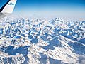
Aerial view of the Pennine Alps from a plane above Mont Blanc (Monte Bianco)
-
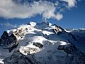
Monte Rosa
-
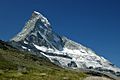
Matterhorn (Cervino)


Highest Peaks
Here are some of the chief peaks in the Pennine Alps:
| Name | Height |
|---|---|
| Dufourspitze | 4,634 m (15,203 ft) |
| Dunantspitze | 4,632 m (15,197 ft) |
| Grenzgipfel | 4,618 m (15,151 ft) |
| Nordend | 4,609 m (15,121 ft) |
| Zumsteinspitze | 4,563 m (14,970 ft) |
| Signalkuppe | 4,554 m (14,941 ft) |
| Dom | 4,545 m (14,911 ft) |
| Liskamm | 4,538 m (14,888 ft) |
| Weisshorn | 4,506 m (14,783 ft) |
| Täschhorn | 4,491 m (14,734 ft) |
| Matterhorn | 4,478 m (14,692 ft) |
| Parrotspitze | 4,432 m (14,541 ft) |
| Dent Blanche | 4,364 m (14,318 ft) |
| Nadelhorn | 4,327 m (14,196 ft) |
| Grand Combin | 4,314 m (14,154 ft) |
| Lenzspitze | 4,294 m (14,088 ft) |
| Stecknadelhorn | 4,241 m (13,914 ft) |
| Castor | 4,230 m (13,878 ft) |
| Zinalrothorn | 4,223 m (13,855 ft) |
| Hohberghorn | 4,219 m (13,842 ft) |
| Alphubel | 4,206 m (13,799 ft) |
| Rimpfischhorn | 4,199 m (13,776 ft) |
| 4,190 m (13,747 ft) |- | Dent d'Hérens | 4,171 m (13,684 ft) |- | Breithorn | 4,164 m (13,661 ft) |- | Bishorn | 4,153 m (13,625 ft) |- | Breithornzwillinge | 4,139 m (13,579 ft) |- | Pollux | 4,092 m (13,425 ft) |- | Ober Gabelhorn | 4,073 m (13,363 ft) |- | Dürrenhorn | 4,035 m (13,238 ft) |- | Allalinhorn | 4,027 m (13,212 ft) |- | Weissmies | 4,031 m (13,225 ft) |- | Lagginhorn | 4,010 m (13,156 ft) |}
Glaciers and Ice
The Pennine Alps are home to many large glaciers. These are like huge, slow-moving rivers of ice. They are a big part of the mountain landscape.
Some of the main glaciers include:
- Gorner Glacier
- Corbassière Glacier
- Findel Glacier
- Zmutt Glacier
- Zinal Glacier
- Otemma Glacier
- Allalin Glacier
- Fee Glacier


Mountain Passes

Mountain passes are lower points in a mountain range that allow people to travel from one side to another. They are like natural doorways through the mountains. Here are some of the important passes in the Pennine Alps:
| Mountain pass | location | type | elevation | |
|---|---|---|---|---|
| Sesiajoch | Zermatt to Alagna | snow | 4,424 | 14,515 |
| Domjoch | Randa to Saas-Fee | snow | 4,286 | 14,062 |
| Lisjoch | Zermatt to Gressoney-La-Trinité | snow | 4,277 | 14,033 |
| Mischabeljoch | Zermatt to Saas-Fee | snow | 3,856 | 12,651 |
| Alphubel Pass | Zermatt to Saas-Fee | snow | 3,802 | 12,474 |
| Adler Pass | Zermatt to Saas-Fee | snow | 3,798 | 12,461 |
| Moming Pass | Zermatt to Zinal | snow | 3,745 | 12,287 |
| Schwarztor | Zermatt to Ayas | snow | 3,741 | 12,274 |
| Ried Pass | Sankt-Niklaus to Saas-Fee | snow | 3,597 | 11,800 |
| Neues Weisstor | Zermatt to Macugnaga | snow | 3,580 | 11,746 |
| Allalin Pass | Zermatt to Saas-Fee | snow | 3,570 | 11,713 |
| Col de Valpelline | Zermatt to Aosta | snow | 3,562 | 11,687 |
| Theodulpass | Zermatt to Valtournenche | snow | 3,322 | 10,899 |
| Col de Collon | Arolla to Aosta | snow | 3,130 | 10,270 |
| Cimes Blanches | Valtournenche to Ayas | bridle path | 2,980 | 9,777 |
| Monte Moro | Saas-Fee to Macugnaga | bridle path | 2,862 | 9,390 |
| Great St Bernard | Martigny to Aosta | road | 2,472 | 8,111 |
| Simplon Pass | Brig to Domodossola | road | 2,009 | 6,592 |
Protecting Nature
To keep the Pennine Alps beautiful, several nature parks have been created. These parks help protect the plants and animals that live here. They are found on both the Italian and Swiss sides of the mountains.
Some examples include:
- The Parco Naturale Alta Valsesia in Italy.
- The Riserva Naturale Mont Mars also in Italy.
- The Regional park of Binn valley in Switzerland.
These parks are important for keeping the mountain environment healthy for everyone to enjoy!
See also
 In Spanish: Alpes peninos para niños
