Breithorn facts for kids
Quick facts for kids Breithorn |
|
|---|---|

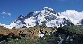
The north side of the Breithorn as seen from Gandegg
|
|
| Highest point | |
| Peak | Breithorn (Western Summit) |
| Elevation | 4,164 m (13,661 ft) |
| Prominence | 433 m (1,421 ft) |
| Isolation | 4.0 km (2.5 mi) |
| Parent peak | Dufourspitze |
| Naming | |
| English translation | Broad Horn |
| Language of name | Lua error in Module:ISO_639_name at line 108: attempt to index local 'data' (a nil value). |
| Geography | |
| Countries | Switzerland and Italy |
| Canton/Region | ValaisAosta Valley |
| Parent range | Pennine Alps |
| Climbing | |
| First ascent | 1813 |
| Easiest route | Basic glacier/snow climb |
The Breithorn is a huge mountain in the Pennine Alps. It is part of a group of peaks with the same name. The highest point is often called Breithorn (Western Summit). This impressive mountain stands right on the border between Switzerland and Italy.
It is a key part of the main chain of the Alps. You can find it halfway between the famous Matterhorn and Monte Rosa mountains. It is also located east of the Theodul Pass. The closest towns to the Breithorn are Zermatt in the Valais region of Switzerland. In Italy, the town of St-Jacques in the Aosta Valley is nearby.
Contents
Breithorn: A Giant of the Alps
The Breithorn is known for being one of the easier 4,000-meter peaks to climb. This makes it popular with many mountaineers. Its name, "Breithorn," means "Broad Horn" in German. This describes its wide, rounded shape.
Where is the Breithorn Located?
The Breithorn is in the Pennine Alps, a mountain range in the western Alps. This range stretches across parts of Switzerland and Italy. The mountain acts as a natural border marker between these two countries. It is a significant peak in this part of Europe.
Who First Climbed the Breithorn?
The first recorded climb of the Breithorn happened in 1813. A group of five brave climbers reached its summit. They were Henry Maynard (climber), Joseph-Marie Couttet, Jean Gras, Jean-Baptiste Erin, and Jean-Jacques Erin. Their successful climb marked an important moment in mountain exploration.
Images for kids
See also
 In Spanish: Breithorn para niños
 | Victor J. Glover |
 | Yvonne Cagle |
 | Jeanette Epps |
 | Bernard A. Harris Jr. |


