
Zermatt facts for kids
Quick facts for kids
Zermatt
|
||
|---|---|---|

June 2022 view from Moosstrasse
|
||
|
||

Zermatt
Location in Switzerland

Zermatt
Location in Canton of Valais
|
||
| Country | Switzerland | |
| Canton | Valais | |
| District | Visp | |
| Area | ||
| • Total | 242.91 km2 (93.79 sq mi) | |
| Elevation | 1,608 m (5,276 ft) | |
| Population
(Dec 2020 )
|
||
| • Total | 5,820 | |
| • Density | 23.959/km2 (62.05/sq mi) | |
| Postal code |
3920
|
|
| Localities | Blatten, Findeln, Gornergrat, Ried, Schwarzsee, Z'mutt | |
| Surrounded by | Alagna Valsesia (IT-VC), Ayas (IT-AO), Ayer, Bionaz (IT-AO), Evolène, Gressoney-La-Trinité (IT-AO), Macugnaga (IT-VB), Randa, Saas-Almagell, Täsch, Valtournenche (IT-AO) | |
| Twin towns | Alfano (Italy) | |

Zermatt is a beautiful village in Switzerland. It is located in the Valais region, where people speak German. About 5,800 people live there all year round.
Zermatt sits high up in the mountains, at the end of the Matter Valley. It is surrounded by some of Switzerland's tallest peaks. The famous Matterhorn mountain is right at its doorstep. Zermatt is known all over the world as a great place for mountaineering and skiing.
Long ago, Zermatt was mostly a farming village. But in 1865, the Matterhorn was climbed for the first time. This exciting event made the village very popular. Many hotels and tourist places were built after that. Today, tourism is a huge part of Zermatt's economy. Many jobs in the town are in hotels or restaurants.
Contents
- What's in a Name?
- Zermatt's Location and Mountains
- Zermatt's Weather
- Fun Things to Do in Zermatt
- Getting Around Zermatt
- Skiing in Zermatt
- Zermatt's Coat of Arms
- Who Lives in Zermatt?
- Famous People from Zermatt
- Special Places
- Zermatt's Economy
- Religion in Zermatt
- Learning in Zermatt
- Images for kids
- See also
What's in a Name?
The name Zermatt comes from the German word matten, which means "meadows". So, Zermatt means "at the meadow". This name first appeared on maps around 1495.
Before that, Zermatt was called Praborno or Prato Borno. Prato also means meadow. People who spoke a language called Romance used this name. But over time, more German-speaking people moved in. This is why the name changed to Zermatt.
Zermatt's Location and Mountains

Zermatt is at the southern end of the Matter Valley. It is almost completely surrounded by the tall mountains of the Pennine Alps. These include Monte Rosa, which has Switzerland's highest peak, the Dufourspitze (4,634 meters or 15,203 feet).
Other huge mountains nearby are the Dom (4,545 meters or 14,911 feet), Liskamm (4,527 meters or 14,852 feet), Weisshorn (4,505 meters or 14,780 feet), and the famous Matterhorn (4,478 meters or 14,692 feet). Many of the highest peaks in the Alps are found around Zermatt.
The Matter Vispa river flows through Zermatt. This river starts from glaciers high up in the mountains. These glaciers include the Gorner Glacier and the Zmutt Glacier.
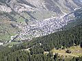
The village of Zermatt is small and easy to walk around. There are three main streets along the river. Many smaller streets are found near the train station and the church. Most places are only a 30-minute walk away.
Some smaller areas, or "suburbs," are part of Zermatt. Winkelmatten/Moos is on a hill to the south. Steinmatten is on the east side of the river.
There are also small villages, called hamlets, in the valleys above Zermatt. These are not usually lived in all year. Some examples are Zum See, Zmutt, and Findeln. Riffelalp, near a train station, is one of the highest hamlets.
Zermatt's Weather
Zermatt has a cool climate. Summers are mild during the day and cool at night. Winters are cold and snowy. The average snowfall in winter is about 128 inches (325 cm).
| Climate data for Zermatt (Reference period 1991–2020) | |||||||||||||
|---|---|---|---|---|---|---|---|---|---|---|---|---|---|
| Month | Jan | Feb | Mar | Apr | May | Jun | Jul | Aug | Sep | Oct | Nov | Dec | Year |
| Mean daily maximum °C (°F) | 0.8 (33.4) |
1.7 (35.1) |
5.7 (42.3) |
9.8 (49.6) |
13.9 (57.0) |
17.8 (64.0) |
20.0 (68.0) |
19.6 (67.3) |
15.4 (59.7) |
11.2 (52.2) |
5.1 (41.2) |
1.5 (34.7) |
10.2 (50.4) |
| Daily mean °C (°F) | −3.9 (25.0) |
−3.4 (25.9) |
0.2 (32.4) |
4.0 (39.2) |
8.1 (46.6) |
11.8 (53.2) |
13.7 (56.7) |
13.3 (55.9) |
9.4 (48.9) |
5.4 (41.7) |
0.3 (32.5) |
−3.0 (26.6) |
4.7 (40.5) |
| Mean daily minimum °C (°F) | −7.4 (18.7) |
−7.3 (18.9) |
−4.0 (24.8) |
−0.7 (30.7) |
3.2 (37.8) |
6.6 (43.9) |
8.3 (46.9) |
8.3 (46.9) |
5.0 (41.0) |
1.4 (34.5) |
−3.1 (26.4) |
−6.3 (20.7) |
0.3 (32.5) |
| Average precipitation mm (inches) | 42 (1.7) |
30 (1.2) |
33 (1.3) |
40 (1.6) |
77 (3.0) |
70 (2.8) |
59 (2.3) |
68 (2.7) |
51 (2.0) |
57 (2.2) |
65 (2.6) |
47 (1.9) |
640 (25.2) |
| Average snowfall cm (inches) | 53 (21) |
44 (17) |
32 (13) |
21 (8.3) |
7 (2.8) |
0 (0) |
0 (0) |
0 (0) |
0 (0) |
9 (3.5) |
42 (17) |
57 (22) |
265 (104.6) |
| Average precipitation days (≥ 1.0 mm) | 6.3 | 5.5 | 5.3 | 6.3 | 9.5 | 9.7 | 9.0 | 9.8 | 7.3 | 7.0 | 7.1 | 6.9 | 89.7 |
| Average snowy days (≥ 1.0 cm) | 6.5 | 6.8 | 4.9 | 3.3 | 0.7 | 0.0 | 0.0 | 0.0 | 0.0 | 1.6 | 4.9 | 7.8 | 36.5 |
| Average relative humidity (%) | 63 | 61 | 60 | 59 | 64 | 66 | 65 | 67 | 70 | 69 | 68 | 66 | 65 |
| Mean monthly sunshine hours | 94 | 109 | 151 | 147 | 155 | 171 | 185 | 176 | 156 | 133 | 89 | 83 | 1,648 |
| Percent possible sunshine | 59 | 61 | 63 | 58 | 54 | 59 | 63 | 65 | 65 | 63 | 55 | 56 | 60 |
| Source: MeteoSwiss | |||||||||||||
Fun Things to Do in Zermatt

Zermatt became famous in the mid-1800s because of British mountaineers. One of them was Edward Whymper. He was part of the first group to climb the Matterhorn in 1865. This climb was very dramatic, with only 3 out of 7 climbers surviving the trip down. You can learn more about this story at the Matterhorn Museum.
Zermatt is a great place to start hiking in the mountains. You can also take cable cars and chair lifts. These lifts take skiers up in winter and hikers in summer. The highest one goes to the Klein Matterhorn (3,883 meters or 12,740 feet). From there, you get amazing views in every direction. You can even cross into Italy by cable car!
There is also a special rack railway called the Gornergratbahn. It is the highest open-air railway in Europe. It takes you up to the top of the Gornergrat mountain (3,089 meters or 10,135 feet). Zermatt is also the end point for the Glacier Express train, which connects to St. Moritz.
Getting Around Zermatt

Zermatt is a special place because it is a car-free zone. This means that most cars with gasoline engines are not allowed. This helps keep the air clean so everyone can enjoy the view of the Matterhorn.
Most vehicles in Zermatt are electric and very quiet. Hotels have small electric shuttles to pick up visitors from the train station. There are also electric taxis and buses. You might even see horse-drawn carriages!
Most visitors arrive in Zermatt by train. You can take a train from the nearby town of Täsch. Trains also come from Visp and Brig, which are on the main Swiss rail network. Zermatt also has a heliport for helicopters. A local helicopter company, Air Zermatt, helps with mountain rescues.
Skiing in Zermatt

Zermatt is famous worldwide for its skiing. Because it is so high up, you can ski there almost all year, even in summer!
Skiing in Zermatt is divided into four main areas:
- Sunnegga
- Gornergrat
- Klein Matterhorn
- Schwarzsee
You can also ski across the border into Italy. Zermatt connects to the ski resorts of Cervinia and Valtournenche through the Plateau Rosa glacier.
In 2008, Zermatt held a special "Infinity Downhill Race." Skiers went down a 20-kilometer (12-mile) course from the Matterhorn Glacier Paradise all the way to Zermatt.
Sunnegga Ski Area
The Sunnegga area is reached by a funicular railway called the SunneggaExpress funicular railway. Then, you can take a gondola to Blauherd and a cable car to the Rothorn mountain (3,103 meters or 10,180 feet). The Rothorn often stays sunny even when Zermatt is cloudy. This area is great for younger skiers because it has fewer very steep slopes.
Gornergrat Ski Area

The Gornergrat area is served by the Gornergrat railway. This train ride takes about 29 minutes to reach the Gornergrat peak (3,089 meters or 10,135 feet). At the top, there is a hotel, restaurant, and shops.
Klein Matterhorn / Schwarzsee Ski Area

Near the south end of Zermatt, the Matterhorn Express gondola takes you up to Furi. From Furi, you can go to Schwarzsee or continue to Trockener Steg. From Trockener Steg, another cable car goes to the Klein Matterhorn.
You can also cross into Italy from Testa Grigia, which is at the top of the Theodul Pass. This connects you to the Italian ski resorts. Zermatt is known for its year-round skiing on the Theodul Glacier behind the Klein Matterhorn.
A new cable car, the 3S Glacier Ride, opened in 2018. It takes 2,000 people per hour to Klein Matterhorn in just 9 minutes. In 2023, a new 3S cableway opened, connecting Testa Grigia and Klein Matterhorn, allowing people to walk between Switzerland and Italy.
Zermatt's Coat of Arms
The coat of arms for Zermatt shows a golden lion standing on a green hill. There are two silver stars above it. The background color is red.
Who Lives in Zermatt?

Zermatt has a population of about 5,800 people. In 2013, about 39% of the people living there were from other countries.
Most people in Zermatt speak German as their first language (about 68%). Portuguese is the second most common language (12%), and Italian is third (about 8%).
In 2013, children and teenagers (ages 0–19) made up about 18.5% of the population. Adults (ages 20–64) were about 69.5%, and seniors (over 64) were about 12%.
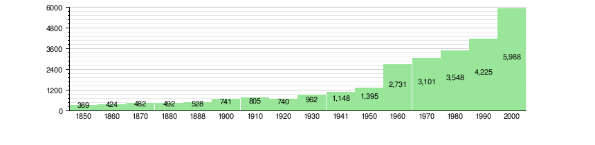
Here's how Zermatt's population has grown over the years:
Famous People from Zermatt

Many interesting people have lived in or visited Zermatt:
- Ulrich Inderbinen (1900–2004) was a famous Swiss mountain climber.
- Otto Furrer (1903–1951) was a Swiss alpine skier and world champion.
- Anni-Frid Lyngstad (born 1945), a lead singer from the famous music group ABBA, lived in Zermatt for many years.
- Max Julen (born 1961) is an Olympic Champion in Giant Slalom skiing from Zermatt.
- Fränzi Aufdenblatten (born 1981) is a retired Swiss World Cup alpine ski racer.
- Andreas Steindl (born 1989) is a Swiss mountain climber and guide.
Special Places
The ancient rock carvings and grinding stone at Hubelwäng are very important. They are listed as a special heritage site of national significance in Switzerland.
Zermatt's Economy

Zermatt's economy relies heavily on tourism. About half of all jobs in the town are in hotels and restaurants. In 2012, there were over 6,300 jobs in Zermatt. Most of these jobs were in the service industry, like tourism.
Religion in Zermatt

Most people in Zermatt are Roman Catholic (about 74%). About 7.6% belong to the Swiss Reformed Church. There are also people who follow other Christian churches, Islam, and Buddhism. Some people do not belong to any church. An English Church was founded in Zermatt in 1870 for English speakers.
Learning in Zermatt
In Zermatt, many people have finished high school. Some have also gone on to college or university.
The school system in Valais Canton offers a year of non-required Kindergarten. Then, students go to six years of primary school. After that, they have three years of required secondary school. Some students then go on to advanced schools.
In the 2010-2011 school year, Zermatt had 677 students. There were 106 kindergarten students and 458 primary school students. There were also 219 students in lower secondary school.
Images for kids
-
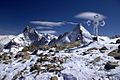
The high summits around Zermatt
-
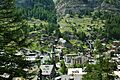
View of Zermatt with the main church (from the east side)
-
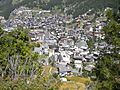
View of the centre of Zermatt (from the west side)
-
View from Riffelalp towards Zermatt
-
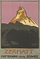
Poster by Emil Cardinaux advertising Zermatt (1908)
-
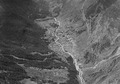
Aerial view (1964)


See also
 In Spanish: Zermatt para niños
