
Riederalp facts for kids
Quick facts for kids
Riederalp
|
|||
|---|---|---|---|
|
Municipality
|
|||
 |
|||
|
|||

Riederalp
Location in Switzerland

Riederalp
Location in Canton of Valais
|
|||
| Country | Switzerland | ||
| Canton | Valais | ||
| District | Raron | ||
| Area
Lua error in Module:Wd at line 1575: attempt to index field 'wikibase' (a nil value).
|
|||
| • Total | Lua error in Module:Wd at line 1,575: attempt to index field 'wikibase' (a nil value). km2 (Formatting error: invalid input when rounding sq mi) | ||
| Elevation | 1,905 m (6,250 ft) | ||
| Population
(2018-12-31)Lua error in Module:Wd at line 1575: attempt to index field 'wikibase' (a nil value).
|
|||
| • Total | Lua error in Module:Wd at line 1,575: attempt to index field 'wikibase' (a nil value). | ||
| Time zone | UTC+01:00 (Central European Time) | ||
| • Summer (DST) | UTC+02:00 (Central European Summer Time) | ||
| Postal code(s) |
3987 Riederalp
3983 Goppisberg, Greich 3986 Ried-Mörel |
||
| SFOS number | Lua error in Module:Wd at line 1575: attempt to index field 'wikibase' (a nil value). | ||
| Surrounded by | Betten, Bitsch, Filet, Mörel, Naters, Termen | ||
| Website | SFSO statistics |
||


Riederalp is a small town, also called a municipality, located in the Valais area of Switzerland. It is part of the Raron district. Riederalp was formed in 2003 when three smaller towns – Goppisberg, Greich, and Ried-Mörel – joined together.
Contents
Exploring Riederalp's Location and Landscape
Riederalp covers an area of about 21 square kilometers (8.1 square miles). A large part of this land, about 42%, is covered by forests. Another 27.7% is used for farming. Only a small portion, 3%, has buildings or roads. The rest of the land is not used for farming or building.
Where is Riederalp Located?
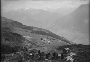
This mountain resort sits on a sunny, south-facing area. It is located south of the Aletsch Glacier, which is Europe's largest glacier. The glacier is about 23 kilometers (14 miles) long. Riederalp is in the Bernese Alps mountain range.
Amazing Mountain Views
The village of Riederalp is high up, at about 1,930 meters (6,330 feet) above sea level. From here, you can see amazing views of the Pennine Alps. You can even spot some of the tallest peaks, like the Fletschhorn, Dom, and the famous Matterhorn.
Understanding Riederalp's Population


Riederalp has a population of about 555 people. In 2008, about 10.6% of the people living there were from other countries. Over ten years, from 2000 to 2010, the number of people living in Riederalp went down slightly. This was mainly because some people moved away.
Languages Spoken in Riederalp
Most people in Riederalp speak German as their main language. About 95.6% of the population uses German. The second most common language is Serbo-Croatian, spoken by 1.9% of the people. French is the third most common, spoken by 0.8%.
Age Groups in the Community
In 2000, children and teenagers (up to 19 years old) made up about 23.9% of Riederalp's population. Adults (20 to 64 years old) were the largest group, at 59.4%. Seniors (over 64 years old) made up 16.7% of the population.
Important Places and Heritage Sites
The villages of Goppisberg and Greich, which are now part of Riederalp, are special. They are listed as Swiss Heritage Sites. This means they have important historical or cultural value and are protected.
Riederalp's Economy and Jobs
In 2010, Riederalp had a low unemployment rate of 2%. This means most people who wanted to work had jobs.
Types of Jobs Available
In 2008, many people worked in the tourism industry. About 239 people had jobs in the service sector, which includes hotels and restaurants. There were 37 businesses in this sector. About 62 people worked in farming, and 9 people worked in construction.
How People Travel to Work
Many people in Riederalp use public transportation to get to their jobs. About 28.9% of the working population takes buses or trains. Another 20.9% use their own cars to travel to work.
Education for Riederalp's Students
During the 2010–2011 school year, 21 students were part of the Riederalp school system.
School System in Valais
In the Valais area, young children can attend one year of Kindergarten. In Riederalp, there were 7 kindergarten students in one class. After kindergarten, students go to primary school for six years. Riederalp had 2 classes and 21 students in primary school.
Secondary School Options
After primary school, students attend three years of mandatory secondary school. Then, they can choose to go to advanced schools for three to five more years. All older students from Riederalp go to secondary schools in nearby towns.
Sports and Activities in Riederalp

Riederalp is a great place for winter sports. It is a car-free village, meaning you can only reach it by cable car. This makes it a peaceful place for visitors.
Skiing and Snowboarding
The area has about 30 kilometers (19 miles) of ski slopes. These slopes are mostly good for beginners and intermediate skiers. Expert skiers and snowboarders can find more challenging areas off the main slopes.
Ski Lifts and Trails
Riederalp and the nearby Bettmeralp have seven ski lifts. These lifts help people get up the mountain to enjoy the slopes. There are also 19 kilometers (12 miles) of trails for cross-country skiing.

Winter Walking Paths
If you enjoy walking in the snow, Riederalp has about 25 kilometers (16 miles) of winter walking paths around the village. There is also a sports center and an indoor swimming pool in Bettmeralp for more activities.
Riederalp's Ski Lift System
You can get to Riederalp using two main ways: Aerial tramways or Gondola lifts from the town of Mörel. Here are some of the main ski lifts in the area:
| Name | Type | Ground Station Height | Mountain Station Height | Slope Length | People per Hour | Built Year |
|---|---|---|---|---|---|---|
| Mörel Ried-Mörel |
Aerial tramway | 759 meters (2,490 ft) | 1,200 meters (3,900 ft) | 1,037 meters (3,402 ft) | 700 | 1996 |
| Ried-Mörel Riederalp |
Gondola | 1,200 meters (3,900 ft) | 1,951 meters (6,401 ft) | 1,980 meters (6,500 ft) | 700 | 1987 |
| Mörel Riederalp |
Aerial tramway | 759 meters (2,490 ft) | 1,950 meters (6,400 ft) | 2,798 meters (9,180 ft) | 500 | 1974 |
| Moosfluh | Gondola | 1,886 meters (6,188 ft) | 2,335 meters (7,661 ft) | 1,798 meters (5,899 ft) | 2200 | 1995 |
| Riederfurka | Chairlift | 1,876 meters (6,155 ft) | 2,119 meters (6,952 ft) | 702 meters (2,303 ft) | 2050 | 1991 |
| Hohfluh | Chairlift | 1,929 meters (6,329 ft) | 2,227 meters (7,306 ft) | 1,010 meters (3,310 ft) | 1090 | 1977 |
| Golmenegg | Surface lift | 1,954 meters (6,411 ft) | 2,100 meters (6,900 ft) | 906 meters (2,972 ft) | 900 | 1970 |
| Alpenrose 1 | Surface lift | 1,903 meters (6,243 ft) | 1,935 meters (6,348 ft) | 179 meters (587 ft) | 1000 | 1980 |
| Alpenrose 2 | Surface lift | 1,903 meters (6,243 ft) | 1,935 meters (6,348 ft) | 179 meters (587 ft) | 720 | 1980 |
See also
 In Spanish: Riederalp para niños
