
Diamond Peak (Oregon) facts for kids
Quick facts for kids Diamond Peak |
|
|---|---|

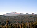
Diamond Peak volcano in October 2005, with the smaller Mount Yoran to the right
|
|
| Highest point | |
| Elevation | 8,748 ft (2,666 m) NAVD 88 |
| Geography | |

Diamond Peak
Location in Oregon
|
|
| Parent range | Cascades |
| Topo map | USGS Diamond Peak |
| Geology | |
| Age of rock | Less than 100,000 years |
| Mountain type | Shield volcano with a stratocone |
| Volcanic arc | Cascade Volcanic Arc |
| Last eruption | More than ~11,000 years ago, but less than 100,000 years ago |
| Climbing | |
| First ascent | 1852, John Diamond and William Macy |
| Easiest route | Hike or climb |
Diamond Peak is a cool volcano located in central Oregon, right on the border of Klamath and Lane counties. It's mostly a shield volcano, which means it has gentle slopes like a warrior's shield. But it also has some features of a stratocone, which is a bit steeper.
Diamond Peak is part of the Cascade Volcanic Arc. This is a chain of volcanoes that stretches from southern British Columbia down through Oregon to Northern California. The mountain stands tall at 8,748 feet (2,666 m) and is found near Willamette Pass. It's inside the Diamond Peak Wilderness, which is part of the Deschutes and Willamette national forests.
The volcano is surrounded by thick coniferous forests. You can even see it from far away, like from the hills near Eugene. Diamond Peak has some fun routes for climbing and scrambling, which is like a mix of hiking and easy climbing.
This volcano is made mostly of a rock called basaltic andesite. It has slopes that are quite steep for a shield volcano. Its center is made of pyroclastic rock, which are bits of rock and ash thrown out during eruptions. Diamond Peak also has smaller mountains nearby, like Mount Yoran and Lakeview Mountain, plus several cinder cones (small, cone-shaped volcanoes). Long ago, glaciers carved out parts of Diamond Peak, leaving behind bowl-shaped hollows called cirques.
Contents
Exploring Diamond Peak's Location

Diamond Peak is about 20 miles (32 km) north of Mount Bailey and Diamond Lake. It's the most important landmark in the Willamette Pass area, right on the county line between Klamath and Lane. Standing at 8,748 feet (2,666 m), you can spot it from many other mountain tops in western Oregon.
The Diamond Peak Wilderness
The Diamond Peak Wilderness is a huge natural area. It covers about 52,611 acres (212.91 km2). This wilderness is located 62 miles (100 km) southeast of Eugene and 64 miles (103 km) southwest of Bend. It's managed by both the Willamette National Forest and the Deschutes National Forest.
This wild area includes 14 miles (23 km) of the famous Pacific Crest Trail. It also has 38 miles (61 km) of other trails for hiking. The forests around Diamond Peak are home to many lakes and creeks. The wilderness area goes from 4,790 feet (1,460 m) up to the peak's 8,748 feet (2,666 m). Diamond Peak is the tallest mountain here. But there are three other peaks over 7,000 feet (2,100 m): Mount Yoran, an unnamed peak, and Lakeview Mountain. In winter, it's hard to get to the wilderness by road. But you can reach its northern side from Gold Lake Sno-Park on Oregon Route 58.
How Diamond Peak Was Formed
Diamond Peak is part of the Cascade Volcanoes. These volcanoes are in the eastern part of the Cascade Range, known as the High Cascades. They formed towards the end of the Pleistocene Ice Age. These mountains sit on top of older volcanoes that sank due to cracks in the Earth's crust. The High Cascades are mostly made of volcanoes that formed in the last 15 million years.

Diamond Peak is a shield volcano. It's made of about 3.6 cubic miles (15 km3) of basaltic andesite and 1.2 cubic miles (5 km3) of andesite. It's sometimes called a "modest stratocone" because its sides are steeper than a typical shield volcano. This is due to the pyroclastic rocks found deep inside it. Diamond Peak is one of the few shield volcanoes in the Cascades that also produced andesite lava. Other similar volcanoes include Mount Defiance and Mount Bailey.
The main cone of Diamond Peak is made of pyroclastic material. This includes basaltic andesite cinders and glassy scoria. It also has thin layers of basaltic andesite lava flows. Diamond Peak actually has two volcanic cones that overlap. The older cone forms its lower northern peak. The volcano does not show signs of producing lahars, which are dangerous mudflows from volcanoes.
Volcanic activity started at a vent near Diamond Peak's northern summit. Soon after, eruptions began at a second, slightly higher vent closer to the southern summit. Diamond Peak's eruptions always produced basaltic andesite lava. Over time, the lava likely became richer in silicon dioxide. The lava flows from the volcano are between 6 to 30 feet (1.8 to 9.1 m) thick.
The volcano is older than the last glacial period, which ended 11,000 years ago. But it's probably younger than 100,000 years old. There's no sign of activity in the last 10,000 years. This suggests that Diamond Peak might now be extinct.
Glaciers used to cover Diamond Peak, but they are gone now. These glaciers carved out several cirques on the mountain. Some of these cirques have talus deposits, which are piles of broken rocks. Glaciers also left behind moraines (piles of rock and dirt) at the lower parts of the wilderness area. Diamond Peak gets a lot of snow because it's right on the Cascade Crest. Some snowfields on the northern side might have been small glaciers as recently as 100 years ago.
Nearby Volcanic Features
Close to Diamond Peak, you'll find Crater Butte. This is a basaltic andesite cinder cone volcano about 2.5 miles (4 km) to the southeast. Redtop Mountain is another volcano, about 6.2 miles (10 km) to the east, made of basalt. Both are likely about the same age as Diamond Peak. They are made of layers of red and black lapilli, scoria, and volcanic bombs.
Emigrant Butte is a basaltic andesite peak about 5.6 miles (9 km) to the south. It has been changed more by glaciers, so it's probably older. Mount Yoran is a much older mountain made from basaltic andesite lava. Its peak sticks out from the northern slope of Diamond Peak. Scientists have used K–Ar dating to find out that Mount Yoran is between 520,000 and 220,000 years old. Mount Yoran is often seen as one of Diamond Peak's smaller features, along with the Diamond Rockpile cinder cone and Crater Butte.
Animals and Plants of Diamond Peak
The plants and animals around Diamond Peak are typical for the Oregon Cascades. The forests in the wilderness area have trees like lodgepole pine, western white pine, mountain hemlock, noble fir, and silver fir. The timberline, where trees stop growing due to elevation, is around 7,775 feet (2,370 m). Near Yoran Lake, you can find forests of Engelmann spruce, silver fir, and noble fir, along with wet meadows.
You'll find common animals from the Cascade Arc here. These include Roosevelt elk, black-tailed deer, red squirrels, and snowshoe hares. Many different bird species also live here. Larger animals like the American black bear and cougar are also in the area. Lakes in the wilderness are full of Trout species, especially brook trout and rainbow trout. Be aware that there are many mosquitoes, especially in early summer!
Human History at Diamond Peak
The first recorded climb of Diamond Peak was in July 1852. Two men named William Macy and John Diamond made the climb. They were part of a group surveying for a new road. This road later became known as the Free Emigrant Road. They named the peak after John Diamond, who was a pioneer from Eugene.
The road was finished in late September 1853. Just days later, over 1,000 people with 250 wagons arrived at the Deschutes River near what is now Bend. These travelers were known as the "Lost Wagon Train of 1853." They were following Elijah Elliott through the central Oregon high desert on a route called the Elliott Cutoff. It took time to find the new road. The road led them to Emigrant Pass by Summit Lake and then down the western side of the pass. In mid-October, settlers from the upper Willamette Valley found the travelers on the Middle Fork Willamette River. A big rescue effort helped the travelers reach the settlements. This event actually doubled the population of Lane County!
Diamond Peak and its wilderness area have not had any big mining operations. There are some old placers (places where valuable minerals collect) along Crescent Creek to the east. But no other important minerals have been found nearby. Cinder from Red Mountain and Crater Butte could be used for building roads. However, there's plenty of cinder and rock outside the wilderness area. The closest mining happened far away, about 20 to 25 miles (32 to 40 km) west of Diamond Peak. Also, the volcano isn't a good source for geothermal energy because there are no hot springs nearby. So, in the 1980s, experts decided there wasn't much future for mining or geothermal energy at Diamond Peak.
Fun Things to Do at Diamond Peak
Even though you can't drive to Diamond Peak on paved roads, the Pacific Crest Trail runs right next to its eastern side. There isn't a clear path to the very top of Diamond Peak, and it has several peaks, which can make finding the highest point tricky. But climbing Diamond Peak isn't a super technical climb. It's more of a tough hike and scramble. You'll climb about 4,100 feet (1,200 m) and walk for 10 to 12 miles (16 to 19 km). The whole trip usually takes six to eight hours.
Climbers can start their journey to Diamond Peak from two main trailheads: Rockpile and Summit Lake. These are southeast of Oakridge and Eugene. The two main paths to the southern summit offer amazing views of Summit Lake and Mount Thielsen.
Another way to climb Diamond Peak starts from Corrigan Lake. You can get there by forest roads about 30 miles (48 km) past Hills Creek Reservoir near Oakridge. The Corrigan Lake Trailhead begins at 5,536 feet (1,687 m). It follows a forest trail towards the western side of Diamond Peak. This is a challenging trip. You might need crampons (spikes for your shoes) and an ice axe if there's a lot of snow and ice. Be careful, as there can be avalanche dangers on the western side of Diamond Peak. This climb is about 8 miles (13 km) round trip, taking you all the way to the peak's 8,748 feet (2,666 m) elevation.
Images for kids
-
Diamond Peak volcano in October 2005, with the smaller Mount Yoran to the right
- [a] This is the acreage given by the United States Forest Service websites; Wuerthner (2003) lists the acreage as 52,337 acres (211.80 km2).
- [b] Sherrod et al. (1983) list Mount Yoran as a stratovolcano.
