Mount Defiance (Oregon) facts for kids
Quick facts for kids Mount Defiance |
|
|---|---|
| Highest point | |
| Elevation | 5,010 ft (1,527 m) NAVD 88 |
| Prominence | 1,520 ft (463 m) |
| Geography | |
| Location | Hood River County, Oregon, U.S. |
| Parent range | Cascades |
| Topo map | Mount Defiance |
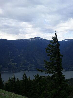
Mount Defiance is a tall mountain peak in the US state of Oregon. It is located near the beautiful Columbia River Gorge, a large canyon carved by the Columbia River. This mountain is part of the Mark O. Hatfield Wilderness area, which is inside the Mount Hood National Forest.
Contents
About Mount Defiance
Mount Defiance stands in Hood River County, Oregon. It is known for being a challenging climb. Many people consider the trail up Mount Defiance one of the hardest hikes in the Columbia River Gorge area.
How Tall is Mount Defiance?
Mount Defiance reaches an elevation of 5,010 feet (1,527 m) (about 1,527 meters) above sea level. This makes it a very high point in the region.
Climbing Mount Defiance
The hiking trail to the top of Mount Defiance starts from the Starvation Creek Trailhead. Hikers gain about 5,000 feet (1,500 m) (1,524 meters) in elevation over a distance of 6 miles (9.7 km) (about 9.7 kilometers). This means the trail goes up very steeply!
What is Mount Defiance Made Of?
Mount Defiance is mostly made up of different kinds of lava flows. These are rocks that formed when hot, melted rock from inside the Earth cooled down.
The bottom part of the mountain is made of basalt. Basalt is a dark, fine-grained volcanic rock. It comes from an old shield volcano. A shield volcano is a wide volcano with gentle slopes, shaped like a warrior's shield. The top of Mount Defiance is covered with a rock called andesite. Andesite is another type of volcanic rock, often lighter in color than basalt.
 | May Edward Chinn |
 | Rebecca Cole |
 | Alexa Canady |
 | Dorothy Lavinia Brown |


