Cape Perpetua facts for kids
Quick facts for kids Cape Perpetua |
|
|---|---|
Cape Perpetua Whispering Spruce view
|
|
| Location | Lincoln County, Oregon, USA |
| Nearest city | Yachats, Oregon |
| Governing body | United States Forest Service |
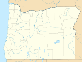
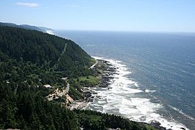
Cape Perpetua is a huge, forested piece of land that sticks out into the Pacific Ocean on the central Oregon Coast. You can find it in Lincoln County, Oregon. The United States Forest Service takes care of this land as part of the Siuslaw National Forest.
Contents
Where is Cape Perpetua Located?
Cape Perpetua is about 2 miles (3.2 km) south of Yachats, Oregon. It sits right along U.S. Route 101. This area is a typical Pacific Northwest headland. It forms a tall, steep cliff above the ocean.
How High is Cape Perpetua?
At its highest point, Cape Perpetua rises over 800 feet (244 m) above the sea. From the top, you can see about 70 miles (113 km) of the Oregon coastline. On a clear day, you can even see as far as 37 miles (60 km) out into the ocean!
The History of Cape Perpetua
|
Cape Perpetua Shelter and Parapet
|
|
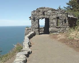
West Shelter observation point
|
|
| Lua error in Module:Location_map at line 420: attempt to index field 'wikibase' (a nil value). | |
| Nearest city | Yachats, Oregon |
|---|---|
| Built | 1933 |
| Architect | Civilian Conservation Corps; United States Forest Service |
| NRHP reference No. | 88002016 |
| Added to NRHP | March 17, 1989 |
People have lived near Cape Perpetua for a very long time. For at least 6,000 years, Native Americans gathered food here. They hunted for mussels, crabs, sea urchins, and clams along the coast.
Early Inhabitants and Their Name for the Cape
Cape Perpetua was part of the land of the Alsea people. In their language, they called the Cape Halqaik. This name might mean something like 'exposed place'. You can still find clues about their lives today. Huge piles of discarded mussel shells are along the shore near the Cape Perpetua Visitor Center.
How Cape Perpetua Got Its Name
Captain James Cook named the cape on March 7, 1778. He was exploring and looking for a way to get from the Pacific Ocean to the Atlantic. Cook named it Perpetua because he discovered it on St. Perpetua's Day.
Building Roads and Trails
The area became part of the Siuslaw National Forest in 1908. In 1914, the United States Forest Service built a narrow road into the cliff. They also built a wooden bridge over the Yachats River. This opened up travel between Yachats and Florence. The wooden bridge was later replaced with a strong steel one in 1926. The Cape Perpetua part of Highway 101 was built in the 1930s.
The Civilian Conservation Corps at Cape Perpetua
In 1933, a special camp was built at the foot of the cape. It was for the Civilian Conservation Corps (CCC). The CCC was a program that helped young men find work during the Great Depression. These workers built the Cape Perpetua campground and a network of hiking trails. They also built the West Shelter observation point near the top of the cape.
Cape Perpetua During World War II
During World War II, the West Shelter was used as a lookout station. People watched the coast from there. A large defense gun was even placed there for a short time. A special radar system was also set up to use the height of the cape. The Cape Perpetua Shelter and Parapet were added to the National Register of Historic Places in 1989.
Exploring the Cape Perpetua Scenic Area
The Forest Service created the Cape Perpetua Scenic Area in the 1960s. They also built the Cape Perpetua Visitor Center. They wanted to show off the amazing beauty of the central Oregon Coast. This scenic area covers 2,700 acres (1,100 ha) of very old trees. These include spruce, Douglas fir, and western hemlock.
Fun Activities at Cape Perpetua
There are many things to do in the Cape Perpetua Scenic Area. You can go camping, have a picnic, or hike on the trails. It's also a great place for sightseeing and watching for whales. The visitor center has daily programs to learn more.
Hiking Trails and the Silent Sentinel
There are 26 miles (42 km) of hiking trails that connect through old forests. Some trails lead to tide pools along the Pacific Ocean. One special trail leads to a 600-year-old giant Sitka spruce tree. It is known as the Silent Sentinel of the Siuslaw. This tree is over 185 feet (56 m) tall. Its base is about 40-foot (12 m) around! In 2007, this ancient tree was named an Oregon Heritage Tree. This helps make sure it stays protected.
Unique Coastal Features
Along the Cape Perpetua coastline, you'll find some amazing natural features.
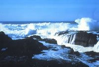
- The Devils Churn: This is a long crack in the coastal rock. Ocean waves rush in and fill it up. Sometimes, incoming and outgoing waves crash together, making a big splash!
- The Spouting Horn: Located at Cook's Chasm, this is a saltwater fountain. It shoots water into the air, powered by the ocean tide.
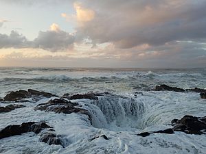
- Thor's Well: This is another saltwater fountain on a nearby rocky plateau. It's like a giant drain in the ocean!
Both Thor's Well (at 44°16′42″N 124°06′49″W / 44.278421°N 124.113499°W) and Spouting Horn (at 44°16′39″N 124°06′47″W / 44.277497°N 124.112994°W) are best seen around high tide. The height of the tide and the ocean swells make them more spectacular. These spots are popular, but they can be dangerous, especially during high tide or winter storms. Always be careful!
The Cape Perpetua Visitor Center
The Cape Perpetua Visitor Center is about 2 miles (3.2 km) south of Yachats. From its deck, you can see amazing views of the ocean and coast. It's a great spot to watch for migrating gray whales. Inside, the visitor center has exhibits about nature and history. There's also a fun science area for kids, a theater with nature films, and a bookstore. A special radar system was put here in 1943. This was after a Japanese balloon bomb landed near Brookings, Oregon.
See also
 In Spanish: Cabo Perpetua para niños
 | Georgia Louise Harris Brown |
 | Julian Abele |
 | Norma Merrick Sklarek |
 | William Sidney Pittman |


